forums
new posts
donate
UER Store
events
location db
db map
search
members
faq
terms of service
privacy policy
register
login


Location DB > Canada > Quebec > Montérégie Area > Soulanges Canal > Aerial Views and Maps > 7

7 / 9   7

Description
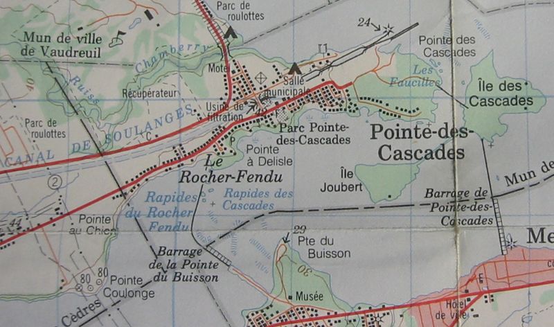
Pointe-des-Cascades area map. Detail from 1986 1:50,000 NTS topo map 31 H/5, "Lachine". The last time I visited it, the area marked "Les Faucilles" was in a state of beautiful desolation.
Controls

Return to Main Location Page

Return to Gallery Overview

Edit this Gallery

Edit this Picture

Un-Subscribe this Picture
Comments
Posted by Deconstrukt 3/15/2021 3:23 AM | remove
  Pointe-des-Cascades is where I spent most of my childhood summer weekends: my grandparents had a chalet on Place des Galets, and I remember my very first UE experience in Les Faucilles when I was 6 or 7 years old: There was a series of abandoned chalets that I used to go explore with my brother. Our grandma told us that they called that place "the Bazar" and that they had to evacuate these chalets because of the varying water level induced by the dams. You cana ctually see on this picture the Bazar part, it's the last street on the right before reaching Les Faucilles (black dots are buildings).
If you'd like to add a comment, please login or register.


All content and images copyright © 2002-2024 UER.CA and respective creators. Graphical Design by Crossfire.
To contact webmaster, or click to email with problems or other questions about this site: UER CONTACT
View Terms of Service | View Privacy Policy | Server colocation provided by Beanfield
This page was generated for you in 203 milliseconds. Since June 23, 2002, a total of 739559471 pages have been generated.