|
|
|
UER Store
|
|
sweet UER decals:

|
|
|
 |
|
|
|
|
Location DB >
Canada >
Quebec >
Montérégie Area >
Soulanges Canal
|
|
Log in to activate viewing options
|
|
|
 |
Publically Viewable |
|
This location has been labeled by its creator as Public, and therefore can be viewed by anyone.
|
|
|
|
|
|
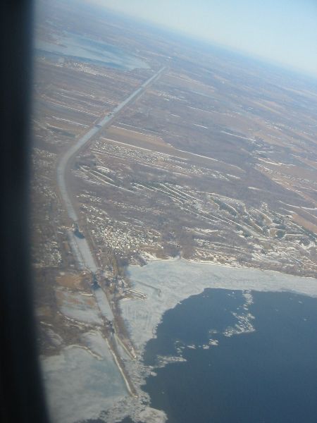
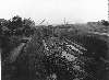
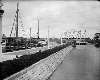
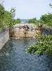
An abandoned shipping canal, 23 kms long with a 14-foot draught. It connects Lac St-Louis with Lac St-Francois, bypassing (what was once) a series of rapids in the Saint Lawrence River. Five locks cover the 84-foot elevation difference between Pointe-des-Cascades at the east end and Coteau-Landing in the west.
The Soulanges Canal was self-powered. Located near the middle of the canal is "Le Petit Pouvoir", a small hydro-electric generating station. It once provided power for the motorized lock gates and illumination for the entire length of the canal at night.
Technically, the Soulanges Canal isn't a real UE destination, but it sure is a nice place to rollerblade or ride your bicycle while checking out the lockworks, bridges and dams. Chemin du Fleuve runs along the north shore of the Saint Lawrence River, just south of the canal. Take this road for your return trip and you'll enjoy many scenic views of the river and the Hydro Quebec installations on it.
|
|
|
Type: Outdoors
Status: Abandoned
Accessibility: Open to the public
Recommendation: Not very exciting (unless you're historically inclined)
|
|
|
Address
Between Pointe-des-Cascades and Coteau-Landing
Montérégie Area, Quebec
Canada
Owner: Ministère des Transports du Québec
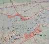
See a map of this location
|
|
|
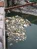
not a good place to go swimming
|
|
|
- 23 km canal
- 5 locks
- Bicycling / rollerblading path along the whole length of it
- Hydro-electric generating station "Le Petit Pouvoir"
- Abandoned / flooded flume west of Lock 4 / Autoroute 30
- Anchor museum and park at Pointe-des-Cascades
- Wilderness area on the west end of Lac Saint-Louis
- Scenic views galore along Chemin du Fleuve
- National Historic Site at Coteau-du-Lac
- Requisite poutine stop La Frite à Brigitte at Coteau-du-Lac
|
|
|
|
|
|
|
|
bicycle or rollerblades, camera, binocs, lunch, snacks, water
|
|
|
Thanks to the Cascades, Split Rock (Rocher Fendu), Cedres and Coteau Rapids, the Saint Lawrence River between Lac Saint-Francois and Lac Saint-Louis is particularly rich with canal-building history.
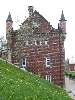
Between 1779 and 1783, the Royal Engineers of the British Army built four small canals here. The first canals were just 2.5 feet deep and the locks were just 6 feet wide. These were the first locks ever built on the Saint Lawrence River, and possibly the first in all of North America. You can see the remains of one of these canals at the National Historic Site at Coteau-du-Lac.
Construction of the Soulanges Canal began in 1892. Built by the Government of Canada to a depth of 14 feet, it opened for navigation in 1899. During the first half of the 20th century, the Soulanges (along with the Lachine, Cornwall and Galop canals) carried the bulk of Canada's shipping. "Lakers" (ships purpose-built to navigate the Great Lakes and their larger canals) used to haul loads of grain down to the terminal at Prescott. Smaller ships, called "canallers", would than haul the grain the rest of the way down the river to Montreal. By the late 1950s, the Soulanges Canal carried 12 million tons of cargo per year.
The original Beauharnois Canal (6 foot draught) was built on the south shore of the Saint Lawrence between 1842 and 1845. In 1929 the Beauharnois Light, Heat and Power Company began excavating a 16-mile long, 3300-foot wide power canal. The Federal Government stepped in to ensure the new canal would be dug deep enough (30-foot draught) to accommodate a future shipping channel. The Saint Lawrence Seaway wouldn't be built for another 25 years yet.
When the modern-day Beauharnois Canal and powerhouse were completed in 1932, this part of the Saint Lawrence River would never be the same. The bulk of the river's flow was diverted away from its original course, and the once-raging rapids that motivated the construction of the Soulanges Canal were rendered into what is basically a lake today.
The completion of the Saint Lawrence Seaway in 1959 brought about the demise of the 14-foot St. Lawrence River canals. The Soulanges Canal was closed to shipping in 1960. Ownership was transferred from the Government of Canada to the Ministère des Transports du Québec in 1965. Apart from the development of the wonderful cycling path, the canal itself has languished ever since.
|
|
|
|
|
Area residents and business interests want to rehabilitate the Soulanges Canal into a world-class boating / tourist destination. Minimal progress has been made as of 2024, which is kind of sad. If this canal were to be opened to recreational boating it would do wonders to connect the eastern Ontario recreational boating network to that of the Montreal area.
|
|
|
|
|
|
|
|
|
|
The moderator rating is a neutral rating of the content quality, photography, and coolness of this location.
| Category |
Rating |
| Photography |
6 / 10 |
| Coolness |
4 / 10 |
| Content Quality |
6 / 10 |
|
|
 This location's validation is current. It was last validated by
Emperor Wang on 4/17/2024 8:46 PM.
This location's validation is current. It was last validated by
Emperor Wang on 4/17/2024 8:46 PM.
|
|
|
on Apr 17 24 at 20:46, Emperor Wang validated this location
on Apr 17 24 at 20:44, Emperor Wang changed the following: Web Links
on Apr 17 24 at 20:43, Emperor Wang changed the following: Web Links
on Apr 17 24 at 20:09, Emperor Wang changed the following: Future Plans
on Apr 15 24 at 23:27, Emperor Wang validated this location
on Apr 15 24 at 23:26, Emperor Wang changed the following: Web Links
on Apr 15 24 at 23:22, Emperor Wang changed the following: Interesting Features, Future Plans
on Apr 15 24 at 23:20, Emperor Wang changed the following: Web Links
on Apr 15 24 at 23:18, Emperor Wang changed the following: Hazards, Interesting Features, Future Plans, Web Links
on Apr 15 24 at 23:06, Emperor Wang changed the following: Web Links
|
|
|
|
|
|
|
Is this location inappropriate / broken / missing key info?
If it's something you can fix, please scroll up and click the EDIT button.
If this location was only posted a few days ago, give the creator time to work on it.
Please try sending a message directly to the creator of the location. You'll find that info at the top of this page.
Otherwise, ONLY if you've already tried to contact the original creator,: Click here to notify an administrator.
|
|
|
|
All content and images copyright © 2002-2024 UER.CA and respective creators. Graphical Design by Crossfire.
To contact webmaster, or click to email with problems or other questions about this site:
UER CONTACT
View Terms of Service |
View Privacy Policy |
Server colocation provided by Beanfield
This page was generated for you in 185 milliseconds. Since June 23, 2002, a total of 739355174 pages have been generated.
|
|