|
|
|
UER Store
|
|
 order your copy of Access All Areas today!
|
|
|


|
|
| Posted by IIVQ |
5/2/2005 8:44 AM | remove |
Could you tell me mora about the old (1845) Beauharnois canal?
|
 |
| Posted by Emperor Wang |
5/2/2005 7:08 PM | remove |
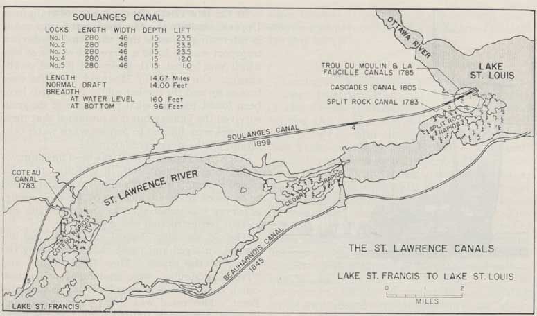
Sure thing, Tijmen. Prior to the opening of the Seaway, this was the only canal that was built on the south shore of the Saint Lawrence. Built between 1842 and 1845, it was 11.5 miles long, had 9 locks, a total lift 82.5 feet, with 9 feet of water over the sills. The upper end is in what's now downtown Valleyfield, and the lower end (since buried) was in the town of Melocheville. It superseded a series of smaller canals built on the north shore of the river by the British Engineers starting in 1779, and was rendered obsolete (for navigation purposes) with the opening of the 14 foot Soulanges canal in 1899. Near the midpoint of the Old Beauharnois, water was diverted to the Canadian Light & Power company generating station on the bank of the Saint Lawrence just east of Saint Timothee. A section of the canal is still visible in Valleyfield, and the power dam building still exists (although landlocked and obsolete since the Saint Lawrence was essentially diverted by the new Beauharnois canal in the 1930s) but apart from that, relics of the old canal are few and far between. I hope to discover and document some more remains this summer. If this isn't enough info, search UER for "Beauharnois" and you'll turn up some photos and links to a few old maps. Cheers!
|
|
| Posted by nostra-YOUPPI! |
5/2/2005 9:55 PM | remove |
using google maps i was able to see the turning basin behind the dam and the road following the banks, the first part of the canal to be filled was downstream fron the power dam as when soulanges opened it no longer served for shipping and was simply a power canal for the dam. highway 30 follows the towpath in that area
|
|
| Posted by Emperor Wang |
5/2/2005 10:11 PM | remove |
All hail Google and its detailed Beauharnois imagery! You can clearly see the towpath and many footpaths along the old canal route. I'll let you know the next time I'm cycling around the lake. We'll have to meet up and do some field research in this area.
For Tijmen:
http://maps.google.com/maps?ll=45.256376,-74.119220&spn=0.041199,0.055532&t=k&hl=en
|
|
| Posted by nostra-YOUPPI! |
5/2/2005 10:48 PM | remove |
yeah i studied that for a while, near the 30 there are some stone structures still around
|
If you'd like to add a comment, please login or register.
|
|
|
|
All content and images copyright © 2002-2024 UER.CA and respective creators. Graphical Design by Crossfire.
To contact webmaster, or click to email with problems or other questions about this site:
UER CONTACT
View Terms of Service |
View Privacy Policy |
Server colocation provided by Beanfield
This page was generated for you in 390 milliseconds. Since June 23, 2002, a total of 739641179 pages have been generated.
|
|