forums
new posts
donate
UER Store
events
location db
db map
search
members
faq
terms of service
privacy policy
register
login


Location DB > Canada > Ontario > Cornwall > Cornwall Canal > Maps and Historical > 1

1 / 13   1

Description
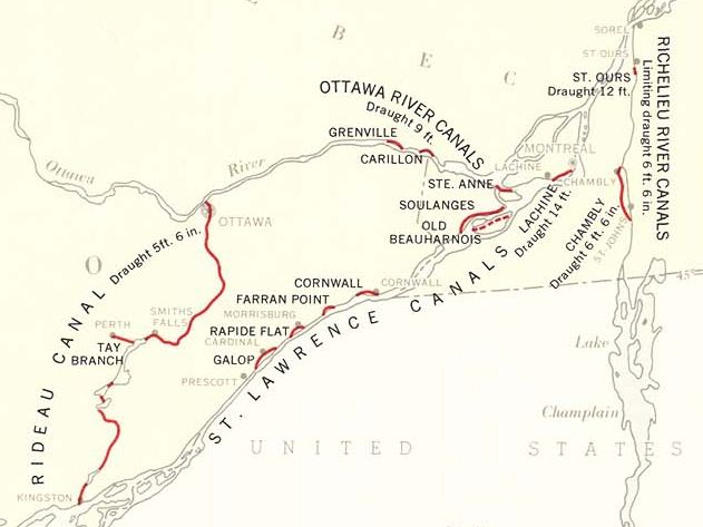
Detail from a map titled "Navigable Waterways, 1957", showing the historic canals of eastern Ontario and Quebec. The. St Lawrence Seaway, still under construction in 1957, is not depicted.

The Cornwall, Farran's Point and Rapide Plat Canals were all inundated with the creation of the big hydro power project at Cornwall. The Galop Canal is still intact, but is disused and has been partially filled in at Cardinal.

In the Montreal area, the Lachine and Ste-Anne's Canals are used by pleasure boaters every summer. Like the St. Lawrence canals in Ontario, the Soulanges and Lachine Canals were abandoned shortly after the Seaway opened. The old Beauharnois Canal has been almost completely filled in since it was replaced by the Soulanges.

Map source: Atlas of Canada, 3rd edition
Controls

Return to Main Location Page

Return to Gallery Overview

Edit this Gallery

Edit this Picture

Un-Subscribe this Picture
Comments
If you'd like to add a comment, please login or register.


All content and images copyright © 2002-2024 UER.CA and respective creators. Graphical Design by Crossfire.
To contact webmaster, or click to email with problems or other questions about this site: UER CONTACT
View Terms of Service | View Privacy Policy | Server colocation provided by Beanfield
This page was generated for you in 343 milliseconds. Since June 23, 2002, a total of 739709606 pages have been generated.