 |
|
|
UER Store
|
|
sweet UER decals:

|
|
|
|
Activity
|
|
552 online
Server Time:
2024-05-09 13:38:09
|
|
|
 Fyrestarter
  
Location: The Netherlands
 | |  | Lime Stone Caves on the Dutch/Belgian Border
< on 1/6/2011 7:36 PM >
|  | | | I believe that these are another section of the cave system explored by cave walker here: http://www.uer.ca/...ow.asp?locid=23802
Apparently there is a total of about 175km of tunnel here, Tours are available in Maastricht of the northernmost portion of the caves. But the southern tunnels are mostly closed off to the public.
details here: http://www.planetw...s-nl-lb-stptcv.htm
[last edit 1/6/2011 7:49 PM by Fyrestarter - edited 1 times]
|
|
Freak
  
Location: Usually Alaska, now MSP.
Gender: Male

Hypocrite
| |  | Re: Lime Stone Caves on the Dutch/Belgian Border
<Reply # 1 on 1/6/2011 11:19 PM >
| | | | Awesome! Those caves/mines/quarries look really cool. I've seen a few in the US like that, but never quite on that scale of complexity and history (obviously).
Turn off the internet and go play outside.
http://spamusement...hp/comics/view/137 |
|
Fyrestarter
Location: The Netherlands
| | Re: Lime Stone Caves on the Dutch/Belgian Border
<Reply # 2 on 1/10/2011 9:50 AM >
| | | | This is the full map which was created by a university of Maastricht geological survey of the region a few years ago. Little else has been done as the caves lie on the border of three Belgian regions and the actual ownership has been in dispute for several years. As a result, the northern chamber is part of a registered tour. and the southern chamber are all closed to the public.
The pentagon outline on the top of the map is actually an overlay of Saint Peters Cathedral in Maastricht.
[last edit 1/10/2011 2:53 PM by Fyrestarter - edited 1 times]
|
|
Dr. Baab

Location: Netherlands
Gender: Male
| | | Re: Lime Stone Caves on the Dutch/Belgian Border
<Reply # 3 on 1/14/2011 7:10 PM >
| | | | Nice, i live really close to this place 
Been here several times during some years, even last week
|
|
dsankt

Location: live and in the fresh

| |  | | | Re: Lime Stone Caves on the Dutch/Belgian Border
<Reply # 4 on 1/14/2011 9:36 PM >
| | | | It's only a couple of hours away, I should hustle my ass down there.
sleepycity.net: watch out for the third rail baby, that shit is high voltage. urbex and urban exploration photography |
|
BertB

Location: Belgium
Gender: Male
| | | Re: Lime Stone Caves on the Dutch/Belgian Border
<Reply # 5 on 1/16/2011 6:57 PM >
| | | | Posted by Fyrestarter
This is the full map which was created by a university of Maastricht geological survey of the region a few years ago. Little else has been done as the caves lie on the border of three Belgian regions and the actual ownership has been in dispute for several years. As a result, the northern chamber is part of a registered tour. and the southern chamber are all closed to the public.
The pentagon outline on the top of the map is actually an overlay of Saint Peters Cathedral in Maastricht.
|
Please get your facts straight..
The original map was published in a book by "Van Schaik" in 1983 !!
The map you post here, is a digitalised version, made by a friend of me about a year ago. He actually used my copy of the book to scan the map. 
The university of Maastricht has nothing to do with it..
Also, the pentagon outline is NOT the St-Pieters Cathedral, but it's a fortress..
Here is a shot I made @ the Zonneberg quarry. It's open for touristic visits..
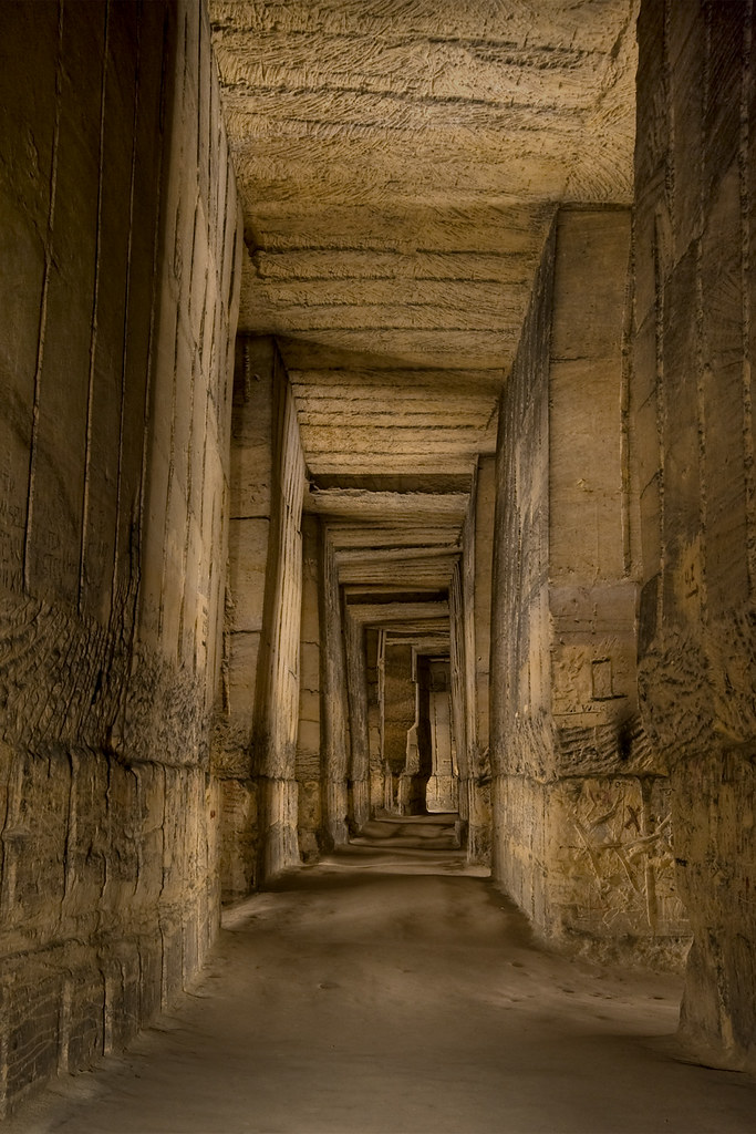
For more shots about this quarry, check this link: http://www.bertbec...-news/83-zonneberg
[last edit 1/16/2011 11:28 PM by BertB - edited 3 times]
|
|
Fyrestarter
Location: The Netherlands
| | Re: Lime Stone Caves on the Dutch/Belgian Border
<Reply # 6 on 1/17/2011 11:07 AM >
| | | | Hey Bert,
Thanks for the correction about the pentagon overlay. It is indeed Fort Sint-Pieter. Also, just for the record Carel Van Schaik attended the university of Utrecht from 1979-1985 during which time he studied Biological Anthropology.
Since the the discovery of Mosasaurus fossils in the limestone caves in 1776, countless geological and anthropological survey have focused on the caves. Among the projects were collaborations between University of Utrecht, University of Maastricht, Brussels Free University, Limburgse University, Twente university, University Geological Survey of Kansas, Royal Society of London and many more.
In 1985 a paper was published discussing the fossilization of vegetation in limestone which draws specific examples from these caves (Patterns in vegetation succession, an ecomorphological study, 1985). This was partially funded by the above mentioned institutes.
So, I'm only speculating here, but I would think that given Van Schaik's academic affiliation in 1983, that the University of Maastrict may have had something to do with efforts to map the caves probably in collaboration with the University of Utrecht where Van Schaik was a doctoral student at the time.
I would think that there are many digital versions of this map floating around out there but I would love to know which Van Shaik book you are referring to especially if there is more information about these caves.
cheers
|
|
Fyrestarter
Location: The Netherlands
| | Re: Lime Stone Caves on the Dutch/Belgian Border
<Reply # 8 on 1/17/2011 1:34 PM >
| | | | Also, here is an article about a Radboud Universiteit Nijmegen project to study the historical relevance of the drawings on the wall of this location.
http://nos.nl/arti...ngen-gevonden.html
(article in Dutch)
|
|
Freak
Location: Usually Alaska, now MSP.
Gender: Male
Hypocrite
| | | Re: Lime Stone Caves on the Dutch/Belgian Border
<Reply # 9 on 1/17/2011 4:15 PM >
|  | | | Posted by Fyrestarter
historical relevance of the drawings on the walls
|
I'm gonna go out on a limb here and assume the walls said something like "Jannsen has a groot big wang" 
Turn off the internet and go play outside.
http://spamusement...hp/comics/view/137 |
|
BertB
Location: Belgium
Gender: Male
| | | Re: Lime Stone Caves on the Dutch/Belgian Border
<Reply # 10 on 1/17/2011 5:13 PM >
| | | | Posted by Fyrestarter
Hey Bert,
Thanks for the correction about the pentagon overlay. It is indeed Fort Sint-Pieter. Also, just for the record Carel Van Schaik attended the university of Utrecht from 1979-1985 during which time he studied Biological Anthropology.
Since the the discovery of Mosasaurus fossils in the limestone caves in 1776, countless geological and anthropological survey have focused on the caves. Among the projects were collaborations between University of Utrecht, University of Maastricht, Brussels Free University, Limburgse University, Twente university, University Geological Survey of Kansas, Royal Society of London and many more.
In 1985 a paper was published discussing the fossilization of vegetation in limestone which draws specific examples from these caves (Patterns in vegetation succession, an ecomorphological study, 1985). This was partially funded by the above mentioned institutes.
So, I'm only speculating here, but I would think that given Van Schaik's academic affiliation in 1983, that the University of Maastrict may have had something to do with efforts to map the caves probably in collaboration with the University of Utrecht where Van Schaik was a doctoral student at the time.
I would think that there are many digital versions of this map floating around out there but I would love to know which Van Shaik book you are referring to especially if there is more information about these caves.
cheers
|
You have the wrong "Van Schaik" in mind. David Cornelius Van Schaik mapped the dutch part of the quarries. The belgian part was mapped by "Breuls, Van Heerdt, Bezem, Sluiter, De groot ..."
Van Schaik published his first book in 1935. He died in 1972. In 1983 this book got published again, but now with a lot of extra pages, containing new information and this large map.
Like I said, the university of maastricht had nothing to do with it and it was unrelated to the finding of fossils and such.
I'll send you a pm with my msn / mail adres if you want more information..
|
|
|
|
All content and images copyright © 2002-2024 UER.CA and respective creators. Graphical Design by Crossfire.
To contact webmaster, or click to email with problems or other questions about this site:
UER CONTACT
View Terms of Service |
View Privacy Policy |
Server colocation provided by Beanfield
This page was generated for you in 203 milliseconds. Since June 23, 2002, a total of 741140431 pages have been generated.
|
|


