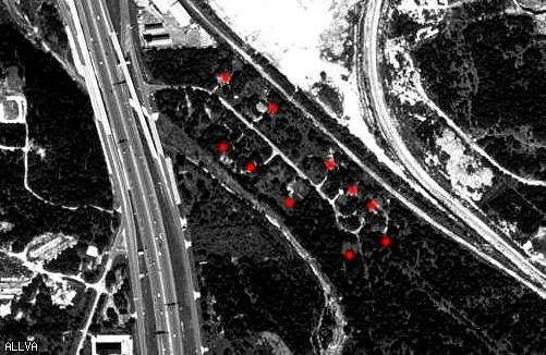
Every red dot designates a house that I was able to see or reach.
This should not, however represent a true number of buildings at this location.
|
|
|
| Posted by 0U812 |
6/7/2006 4:37 PM | remove |
You think this might have been cleared to make room for the highway? Would be interesting to find out. That has happened where I live.
|
 |
| Posted by Allva |
6/10/2006 3:25 PM | remove |
Sure, I've considered it...Actually , that's probably waht happened....
|
|
| Posted by danchez |
11/23/2009 11:51 PM | remove |
is this still there? and when I say there, where is there exactly, your location maps leave a lot to be desired...
|
|
| Posted by searchSA |
9/14/2023 4:52 PM | remove |
I've been searching for this location for quite a few years. I finally found it. It's right past the I-10 & 1604 interchange on the NW of San Antonio. It is now a part of the Leon Creek Greenway bike and hike trail system.
I have not been there, but satellite photos indicate no trace of houses left there aside from, maybe, a few foundations. it's easily and publicly accessible, there's actually a parking lot anyone can park in and is called the Marquis Trailhead which is at what would have been the northern entrance to the neighborhood. A little under half of it is covered by the back of an apartment complex on Vance Jackson Rd. that runs into The Rim shopping center.
Historical Aerials indicates the neighborhood was there as far back as 1955. i cound't tell around what year it was completely abandoned, but the neighborhood's clear definition on aerials is visible as far forward as 1995. Past that, it starts to look less and less defined, which indicates abandonment.
I can only conclude that it was a small community built, probably, shorlty before 1955 and were, indeed, upscale homes for the time period on 1/4-1/2 acre lots. On the other side of I-10, off of Old Fredrickburg Rd. that runs behind the Six Flags Motel 6, there was another set of houses that were very similar to these. As i went through the decades of aerials over both, it's easy to conclude that these two neighborhoods were simply a victim of development. The fact that this particular neighborhood has the massive quarry, of which half became The Rim shopping center, RIGHT next to it (hence the train tracks and train cars), may have something to do with it's abandonment and eventual disappearance. The quarry shows to have stared expanding almost into it by 1973. My bet is the remains of the houses were recently cleared when they started putting the Leon Creek Greenway through the middle of it.
Anyway, you can walk freely through the land it once sat on now and if you go off the paved trail, perhaps find some remanents of it like foundations and missed debris.
|
|
| Posted by THWN2 |
11/8/2023 12:11 AM | remove |
In 1986 they were building I355 I got to see tons of abandoned houses. If only they had this site. It was a street just like in your aerial photo but not grown over. Now I355 is 8/9 feet over the old neighborhood. They had to move roads,an electrical substation, some 345,000 & 138,000 volt power lines. I wonder how much money this cost the tax payers.
|
If you'd like to add a comment, please login or register.
|
|
|