forums
new posts
donate
UER Store
events
location db
db map
search
members
faq
terms of service
privacy policy
register
login


Location DB > England > Shropshire > Ellesmere > Ellesmere Creamery > Maps > Map based on aerial photograph

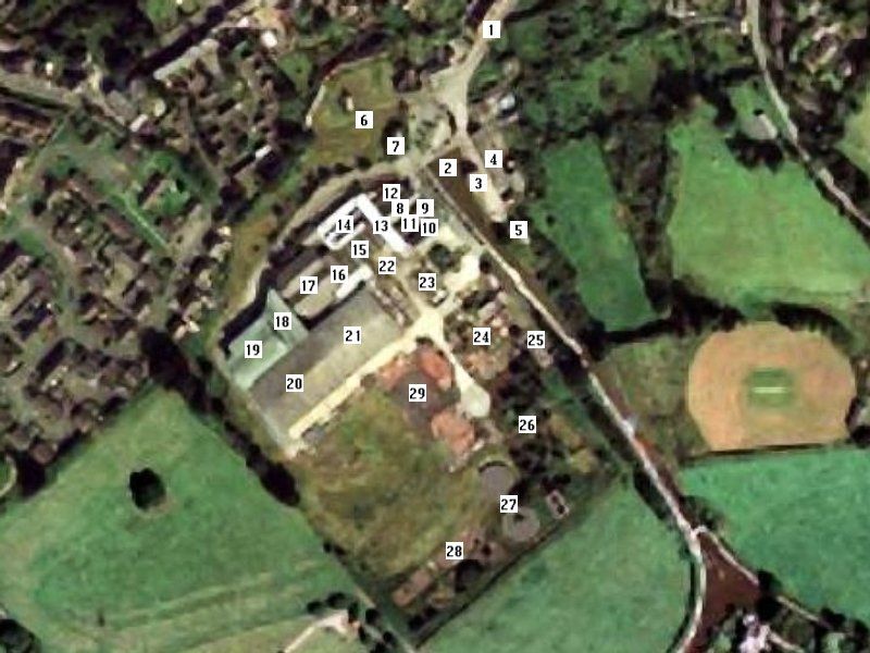
1 / 2   Map based on aerial photograph

Description
1. Wharf Road
2. Canal basin
3. Shropshire Union Canal Company warehouse
4. Dairy Crest Transport depot
5. Boring abandoned house
6. North goods yard
7. Abandoned house once used as offices
8. Central passage
9. Tower
10. Offices
11. Cafeteria
12. Production room with eerie fan
13. Offices
14. Production room
15. Production room
16. Engine Room
17. Two older cold storage rooms
18. Modern covered yard and substation
19. Modern cold storage room
20. Large, modern production room (now burnt)
21. Another large, modern production room
22. Loading bay
23. Weird concrete structures
24. More weird concrete structures
25. Deep tanks of water
26. Overgrown hoppers/silos
27. Disused water treatment plant
28. Beds of loose rubble
29. Paved area and more rubble
Controls

Return to Main Location Page

Return to Gallery Overview

Edit this Gallery

Edit this Picture

Un-Subscribe this Picture
Comments
Posted by SnakeCorp 5/10/2006 8:35 PM | remove
  Very thorough. Full marks to you!
Posted by inventor 5/12/2006 5:05 AM | remove
  Thanks. I hope people can benefit from it in planning an exploration!
If you'd like to add a comment, please login or register.


All content and images copyright © 2002-2024 UER.CA and respective creators. Graphical Design by Crossfire.
To contact webmaster, or click to email with problems or other questions about this site: UER CONTACT
View Terms of Service | View Privacy Policy | Server colocation provided by Beanfield
This page was generated for you in 390 milliseconds. Since June 23, 2002, a total of 738600259 pages have been generated.