|
|
|
UER Store
|
|
 order your copy of Access All Areas today!
|
|
|
|
Activity
|
|
750 online
Server Time:
2024-04-19 14:23:49
|
|
|
 |
|
|
|
|
Location DB >
United States >
New York >
Keene >
Keene's Red Barn
|
|
Log in to activate viewing options
|
|
|
created by Kurt
on 12/26/2018 1:08 AM
last modified by Emperor Wang
on 6/12/2023 3:22 PM
|
|
 |
Publically Viewable |
|
This location has been labeled as Demolished, and therefore can be viewed by anyone.
|
|
|
|
|
|
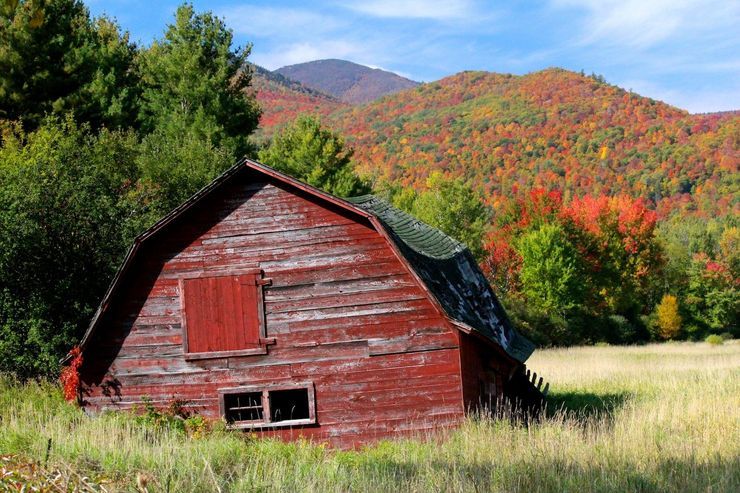
Iconic red barn with stunning views of the Adirondack high peaks in the background.
*Demolished in 2016*
|
|
|
Type: Building
Status: Demolished
Accessibility: Easy
Recommendation: forget it - it's gone
|
|
|
Address
Keene, New York
United States
Owner: State of New York
|
|
|
|
|
The high peaks of the Adirondacks are in the background.
|
|
|
|
|
|
|
|
|
In late December [2016], the rustic red barn that stood at the intersection of Routes 73 and 9N in Keene was taken down by the Department of Environmental Conservation after it became hazardous.
Although not an officially-recognized historic landmark, many who have traveled through Keene saw the barn, with its majestic High Peaks in the background, as a quaint countryside icon.
Since it came down, folks have waxed nostalgic while mourning the abrupt loss of this unassuming structure. I decided to dig into the barn’s history and see if there was more to it than met the eye.
According to longtime Keene resident Tony Goodwin, the land on which the barn was built was once owned by Wallace Murray. “Wal” Murray was an investor and entrepreneur who around 1855 at the age of six moved with his parents, Mr. and Mrs. Owen Murray, to Keene. Murray invested some of his wealth in rebuilding local farms. In the early 1900s, he sold this particular piece of property to Albert Jakes (or Jaques, according to 1940 census records), who along with his wife, Clare Belle, had a farm on Spruce Hill Road (today’s Route 9N). The junction of Routes 73 and 9N was once known as “Holt’s Corners.”
According to Palmieri, Albert Jaques sold the land to Jud Whitney, and Goodwin clarifies that the barn was built in the late 1950s by Reginald Whitney, who once kept cows there. Examination of the 1940 census for Keene show Reginald (then 7 years old) and Judson (then 20 years old) living in the same home on Alstead Hill Road, about four miles northwest from Holt’s Corners. Jud and Reginald may have been brothers. In 1964, Elizabeth Doty, noted that Judson owned a house at the foot of Spruce Hill.
Reginald, possibly along with Jud, ran a small eatery at the red barn until the 1960s. The Whitneys sold the land to the State in 1966 when it was added to the Forest Preserve (Outdoor Recreational Bond Act of 1966 funds were used). Around the same time Route 9N was undergoing improvements. Apparently, DEC made an informal deal to continue haying the land. The barn was leveraged by the State for a short time to house equipment used in the road improvements, and then used to store hay.
Janet Hall, historian for the town of Keene, believes the barn was functional for only a few years, although haying continued in the surrounding field into the early 1980s. The land is now part of the Hammond Pond Wild Forest.
Of course, the history of the land goes back further than Wallace Murray. On J.H. French’s Map of Essex Co., New York (1858), the land is located on lot 19 of Mallory’s Grant. On lot 19, two structures near what would become the intersection of Routes 73 and 9N are depicted by the names “S&F. Shaw” and “B.F. Shaw.” A search of census records shows a B.F. and Silas Shaw each owning 150 acres of land.
A sketch from 1798 of Mallory’s Grant was made following a survey of the 9,973-acre tract by Charles C. Brodhead. The tract is named for Nathaniel Mallory, who (along with other partners) acquired the land. The sketch shows that lot 19 measured 80 chains by 80 chains, or 640 acres.
As a tangent on the history of Keene’s most famous barn and the land on which it resided, I’ll offer a brief commentary on Spruce Hill. Route 9N, once called Spruce Hill Road, goes along Spruce Hill Brook in an east-southeasterly direction from Route 73. I could find no officially identified hill or peak by that name on historic maps, Elizabeth Doty’s regular column “Keene” revealed Spruce Hill’s identity. Doty explained that Spruce Hill is actually two hills with buildings along said road, with a village at the top. Route 9N crests around the entrance to Hurricane Road. Thus, Spruce Hill designates a general region, usually the road itself, and not a once-named peak.
The earliest mention I can find of Spruce Hill in writing is in Alfred Billings Street’s 1869 classic “Indian Pass.” Describing his travels on the road northward from the village of Keene, he mentions their turning onto Spruce Hill (also called Partridge Hill) and ascending for about two miles.
Street recounts, “Turning my head accidentally, a most grand prospect, even in this enchanted region of grand prospects, broke upon me. There surged the Keene Mountains, rolling gigantic billows in softest, sweetest azure upon the valley, like those of an ocean that might whelm the world. The standing forth of the peak of Tahawus on the ascent from the side of Lake Colden, was scarce finer in effect.”
For those who have driven on Route 9N to the west towards Route 73, they can identify with the majestic backdrop Street described. The red barn that was at the forefront of that backdrop may be gone, but the photos and memories of it will long remain.
-- http://www.adirond...ed-barn-keene.html
|
|
|
|
|
|
|
|
|
|
|
|
|
The moderator rating is a neutral rating of the content quality, photography, and coolness of this location.
This location has not yet been rated by a moderator.
|
|
 This location's validation is current. It was last validated by
Emperor Wang on 6/12/2023 3:22 PM.
This location's validation is current. It was last validated by
Emperor Wang on 6/12/2023 3:22 PM.
|
|
|
on Jun 12 23 at 15:22, Emperor Wang validated this location
on Jun 12 23 at 15:22, Emperor Wang changed the following: Web Links
on Dec 26 18 at 17:00, Emperor Wang validated this location
on Dec 26 18 at 16:59, Emperor Wang changed the following: Interesting Features, Media Coverage
on Dec 26 18 at 1:34, Kurt made this location available
on Dec 26 18 at 1:32, Kurt swapped pictures 6 and 7
on Dec 26 18 at 1:32, Kurt swapped pictures 3 and 6
on Dec 26 18 at 1:32, Kurt swapped pictures 5 and 8
on Dec 26 18 at 1:32, Kurt swapped pictures 2 and 6
on Dec 26 18 at 1:32, Kurt updated gallery picture
|
|
|
|
|
|
|
Is this location inappropriate / broken / missing key info?
If it's something you can fix, please scroll up and click the EDIT button.
If this location was only posted a few days ago, give the creator time to work on it.
Please try sending a message directly to the creator of the location. You'll find that info at the top of this page.
Otherwise, ONLY if you've already tried to contact the original creator,: Click here to notify an administrator.
|
|
|
|
All content and images copyright © 2002-2024 UER.CA and respective creators. Graphical Design by Crossfire.
To contact webmaster, or click to email with problems or other questions about this site:
UER CONTACT
View Terms of Service |
View Privacy Policy |
Server colocation provided by Beanfield
This page was generated for you in 78 milliseconds. Since June 23, 2002, a total of 738507077 pages have been generated.
|
|