|
|
|
UER Store
|
|
 order your copy of Access All Areas today!
|
|
|
|
Activity
|
|
878 online
Server Time:
2024-04-26 11:29:50
|
|
|
 |
|
|
|
|
Location DB >
United States >
California >
Holy Jim Canyon >
Trabuco Canyon Mill
|
|
Log in to activate viewing options
|
|
|
created by Cherokee
on 10/5/2014 2:21 AM
last modified by Cherokee
on 10/5/2014 4:46 AM
|
|
 |
Publically Viewable |
|
This location has been labeled by its creator as Public, and therefore can be viewed by anyone.
|
|
|
|
|
|
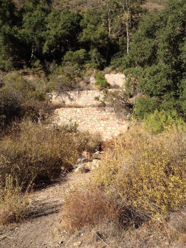
This mill was razed in the 1980s by the Forest Service as part of a "restoration effort" and the historical buildings were lost. It's a shame because before that it was regarded as the "most preserved mine in Orange County." It's a very neat site, and the mine up top was full of frogs when I was there. Even though the buildings are gone, comparing it with historical photos and visiting the site it's fun to compare and figure out where everything was. The stonework on the walls is very impressive.
|
|
|
Type: Mill ruins
Status: Abandoned
Accessibility: Moderate
Recommendation: worth the trip
|
|
|
|
water
air quality
Snakes, poison oak, unstable mine, loose rocks, steep slopes, rough road
|
|
|
Mill ruins, scattered artifacts, peaceful oak woodlands, neat mine tunnel
|
|
|
|
|
|
long pants / sleeves
towelettes
Flashlight if going in the mine
|
|
|
Hiking boots, decent off-road vehicle (most road cars can make it, just don't expect to be flying on this road. It gets hairy)
|
|
|
In 1877, a local resident/prospector discovered tin ore in the hillsides of these mountains, this particular outcrop in Trabuco Canyon (others being in Tin Mine Canyon on the eastern slope). The word spread, but nobody bothered doing a thing about this find of metal until roughly 1903. In 1903, the mining industry descended on the site with force. A large mill was erected and several thousand feet of workings were dug.
The mine closed for good after never seeing a dime of profit. Tin mining was cancelled in 1906 after the mill had only been in operation for a month and a half until the ore was found to be of such low quality the profit margin would be too low to continue to operate.
|
|
|
|
|
|
|
|
|
|
|
|
|
The moderator rating is a neutral rating of the content quality, photography, and coolness of this location.
| Category |
Rating |
| Photography |
5 / 10 |
| Coolness |
6 / 10 |
| Content Quality |
7 / 10 |
|
|
 This location's validation is current. It was last validated by
Mike Dijital on 11/2/2014 10:27 PM.
This location's validation is current. It was last validated by
Mike Dijital on 11/2/2014 10:27 PM.
|
|
|
on Nov 2 14 at 22:27, Mike Dijital validated this location
on Nov 2 14 at 21:01, Cherokee made this location available
on Nov 2 14 at 20:59, Cherokee added some pictures to a gallery
on Nov 2 14 at 20:54, Cherokee created a new gallery
on Oct 5 14 at 4:46, Cherokee changed the following: City
on Oct 5 14 at 4:42, Cherokee updated the main picture
on Oct 5 14 at 4:41, Cherokee changed the following: Publically Viewable
on Oct 5 14 at 4:41, Cherokee changed the following: Description
on Oct 5 14 at 4:39, Cherokee changed the following: Type, Province / State (please use full name), Country, History, Hazards, Interesting Features, Recommendation, Required Equipment, Recommended Equipment, Description, Web Links
on Oct 5 14 at 2:24, Cherokee changed the following: Real Name, Notes for Mods, Owner, Latitude, Longitude, Co-ordinate Accuracy, Prefer Satellite, History, Year Built, Year Closed, Status, Accessibility, Interesting Features, Media Coverage, Future Plans, Description, Web Links
|
|
|
|
|
|
|
Is this location inappropriate / broken / missing key info?
If it's something you can fix, please scroll up and click the EDIT button.
If this location was only posted a few days ago, give the creator time to work on it.
Please try sending a message directly to the creator of the location. You'll find that info at the top of this page.
Otherwise, ONLY if you've already tried to contact the original creator,: Click here to notify an administrator.
|
|
|
|
All content and images copyright © 2002-2024 UER.CA and respective creators. Graphical Design by Crossfire.
To contact webmaster, or click to email with problems or other questions about this site:
UER CONTACT
View Terms of Service |
View Privacy Policy |
Server colocation provided by Beanfield
This page was generated for you in 109 milliseconds. Since June 23, 2002, a total of 739223045 pages have been generated.
|
|