|
|
|
|
|
Location DB >
United States >
Massachusetts >
Boston >
Fort Strong
|
|
Log in to activate viewing options
|
|
|
 |
Publically Viewable |
|
This location has been labeled by its creator as Public, and therefore can be viewed by anyone.
|
|
|
|
|
|
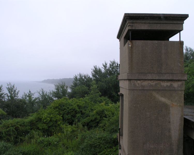
This is a pretty big military bunker on the tip of an Island in boston harbor, well worth the trip if you're into military stuff
|
|
|
Type: Outdoors
Status: Abandoned
Accessibility: Difficult
Recommendation: worth the trip
|
|
|
|
|
|
Its a really cool military base on the tip of an island in boston harbor
|
|
|
fences
cameras
Guard at the end of the bridge to get on the island
|
|
|
|
flashlight
binoculars
gloves
head protection
long pants / sleeves
towelettes
|
|
|
|
Fort Strong (1870 - 1960's), is located on Long Island in Boston Harbor.
It was originally named Long Island Military Reservation until 1899.
Camp Wightman, a Civil War training camp, was located on the island in 1861.
At the end of the Civil War, the government decided to keep Fort Strong which had been located in East
Boston, and move it to Long Island. It was officially designated in 1867 as being located on Long Island. The
name is a dedication to Massachusetts Governor Caleb Strong. [1]
The gun blocks and magazine of Long Island Head Battery (1874 - 1876), a 10-gun battery, still remain.
Endicott period batteries which were located here:
Battery Hitchcock (1899 - 1939)
Battery Ward (1899 - 1939)
Battery Drum (1899 - 1917)
Battery Smyth (1906 - 1921)
Battery Stevens (1906 - 1946)
Battery Taylor (1906 - 1942)
Battery Basinger (1901 - 1947)
A two-gun AA battery was built in the 1920s, extended to three guns in 1935. A mine casemate was
constructed in 1906, which commanded the northern channel (President Roads) harbor minefields until
replaced by Fort Dawes in 1944.
Fort Strong was a NIKE missile launch site in the 1950s, with the control site in Squantum. The Radar
Section, 15th AAA Group, was there from January 1958 to June 1961.
This property had been owned by the Long Island Hospital, and is now operated by The Boston Public
Health Commission.
|
|
|
|
|
|
|
|
|
|
|
 2013
2013
Sun, Apr 21st, 2013
posted by Kurt
3 pictures
|
|
|
|
|
|
|
|
|
The moderator rating is a neutral rating of the content quality, photography, and coolness of this location.
| Category |
Rating |
| Photography |
8 / 10 |
| Coolness |
10 / 10 |
| Content Quality |
10 / 10 |
|
|
 This location's validation is current. It was last validated by
Emperor Wang on 12/19/2020 2:41 PM.
This location's validation is current. It was last validated by
Emperor Wang on 12/19/2020 2:41 PM.
|
|
|
on Dec 19 20 at 14:41, Emperor Wang validated this location
on Dec 19 20 at 14:39, Emperor Wang changed the following: Description
on Dec 17 20 at 17:51, Kurt updated gallery picture
on Dec 17 20 at 17:51, Kurt updated gallery picture
on Dec 17 20 at 17:51, Kurt updated gallery picture
on Dec 17 20 at 17:51, Kurt added some pictures to a gallery
on Dec 17 20 at 17:50, Kurt updated gallery 2013
on Dec 17 20 at 17:50, Kurt updated gallery 2013
on Dec 17 20 at 17:49, Kurt created a new gallery
on Jul 31 14 at 2:10, Mike Dijital validated this location
|
|
|
|
|
|
|
Is this location inappropriate / broken / missing key info?
If it's something you can fix, please scroll up and click the EDIT button.
If this location was only posted a few days ago, give the creator time to work on it.
Please try sending a message directly to the creator of the location. You'll find that info at the top of this page.
Otherwise, ONLY if you've already tried to contact the original creator,: Click here to notify an administrator.
|
|
|