|
|
|
UER Store
|
|
 order your copy of Access All Areas today!
|
|
|
 |
|
|
|
|
Location DB >
Canada >
Nova Scotia >
Roxbury >
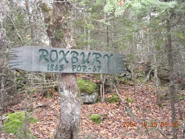
Ghost Town of Roxbury
|
|
Log in to activate viewing options
|
|
|
created by Elle
on 10/11/2010 12:20 AM
last modified by Elle
on 10/11/2010 12:48 AM
|
|
 |
Publically Viewable |
|
This location has been labeled by its creator as Public, and therefore can be viewed by anyone.
|
|
|
|
|
|
Roxbury is a small ghost town outside of Paradise, Nova Scotia. Neat to see the foundations and signs :)
|
|
|
Type: Ghost Town
Status: Abandoned
Accessibility: Moderate
Recommendation: check it out if you're nearby
|
|
|
|
Really Big flies during the summer!
|
|
|
Just past Roxbury is the 3rd largest lake in Nova Scotia. There is also a camp out there where a hermit lives.
|
|
|
|
|
|
ATV - even with 4WD you may not make it.
|
|
|
Camera, lots of bugspray.
|
|
|
From Drobicho.com's blog:
Discover the NS ghost town of Roxbury from the early 1800's, in Annapolis County towards the end of the 8km "Roxbury Road". Depending on your vehicle, you can drive in all the way (4x4) or about 1km and walk / bicycle the rest. It is an old "ox-cart" road which makes easy hiking. The "Roxbury Road" is just outside the village of Paridise in the Annapolis Valley. It goes past a gravel pit where the locals drive their dirt bikes. You can probably drive a normal car in about 1-2km before the road becomes more challenging with rocks and boulders to drive over / around. If you have a Mountain Bike, this would be a nice drive. The locals drive 4-wheeler ATV's up it to a few hunting camps at the far end of the 8km road, which ends at a pretty lake and old water supply dam. You will be surprised when in the middle of no-where (5Km in) you see a big sign "Welcome to Roxbury". From that point onwards for about 1km, you will find little white signs that direct you to the old dug wells and stone foundations of many homes that once were here. There is an old pioneer cemetery too. I followed the sign to the mill pond, but couldn't find it. (seemed to lead to someone's camp / home). Near the rubble of a collapsed building, someone is still maintaining a small vegetable garden. There is a hunt camp on the left. They knew nothing of the reputed hermit of the area. Further past their camp the trail gets rougher, but eventually ends at a beautiful lake, and the remnants of a water control dam. Legend has it that about sixty of the Acadian settlers took flight up the river and hid on the South Mountain (one place was said to have been an area near Paradise, now known as Roxbury, but none are thought to have survived the winter);
There was also, on the point of what is now known as Roxbury Road, a very large Micmac Reserve. The Chief-- was the famous Paul Malti, who is mentioned in several histories of the area. The Micmacs, were then, and still are, mostly Roman Catholics.There are a number of small white signs that point to these type of wells where you will also find stone foundations. .The worst part of the road is just past that sign,so if your brave enough to make it up and over that then Its clear sailing to the site.The first half of the road is worse then the second part.
|
|
|
|
|
|
|
|
|
|
|
|
|
The moderator rating is a neutral rating of the content quality, photography, and coolness of this location.
This location has not yet been rated by a moderator.
|
|
 This location's validation is current. It was last validated by
tribeachpunk on 10/11/2010 2:40 AM.
This location's validation is current. It was last validated by
tribeachpunk on 10/11/2010 2:40 AM.
|
|
|
on Oct 11 10 at 2:40, tribeachpunk validated this location
on Oct 11 10 at 0:48, Elle changed the following: City
on Oct 11 10 at 0:44, Elle made this location public
on Oct 11 10 at 0:44, Elle made this location available
on Oct 11 10 at 0:44, Elle updated a story
on Oct 11 10 at 0:44, Elle updated a story
on Oct 11 10 at 0:34, Elle deleted picture 326765 from gallery Google Photos
on Oct 11 10 at 0:34, Elle updated gallery picture Cemetery
on Oct 11 10 at 0:33, Elle updated gallery picture No more pavement.
on Oct 11 10 at 0:33, Elle updated gallery picture Roxbury!
|
|
|
|
|
|
|
Is this location inappropriate / broken / missing key info?
If it's something you can fix, please scroll up and click the EDIT button.
If this location was only posted a few days ago, give the creator time to work on it.
Please try sending a message directly to the creator of the location. You'll find that info at the top of this page.
Otherwise, ONLY if you've already tried to contact the original creator,: Click here to notify an administrator.
|
|
|
|
All content and images copyright © 2002-2024 UER.CA and respective creators. Graphical Design by Crossfire.
To contact webmaster, or click to email with problems or other questions about this site:
UER CONTACT
View Terms of Service |
View Privacy Policy |
Server colocation provided by Beanfield
This page was generated for you in 328 milliseconds. Since June 23, 2002, a total of 739433081 pages have been generated.
|
|