|
|
|
UER Store
|
|
sweet UER decals:

|
|
|
 |
|
|
|
|
Location DB >
Virgin Island >
St. John >
No city >
Danish Sugar Mill Ruins and Estates
|
|
Danish Sugar Mill Ruins and Estates
|
|
|
Log in to activate viewing options
|
|
|
 |
Publically Viewable |
|
This location has been labeled by its creator as Public, and therefore can be viewed by anyone.
|
|
|
|
|
|
|
|
Type: Building
Status:
Accessibility: Easy
Recommendation: check it out if you're nearby
|
|
|
|
|
|
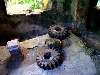
If your a history buff, the old architecture here is interesting. There are occasional huge copper kettles to be found which were used for boiling the molasses. Even rarer are the late 1800's machinery parts.
|
|
|
|
|
|
|
|
|
In a nutshell, Denmark owned the island of St. John in the 17th century, they deforested most of the island to plant slave-run sugar cane plantations for the rum trade. On these plantations were mills ans estate houses, some had a windmill, some had horse drawn grinders and boiling rooms to boil down the sugar cane to molasses. A lot these structures still stand today and are spread out all over the island. Long since decayed and in the elements, most of them are under US National Park jurisdiction and protection being inside the borders of the Virgin islands National Park (which encompasses about 2/3rds of the island) Some of these ruins are tourist traps, some you have to hike a long time to get to, some are completely overgrown and out of site and or on private land. There are even some estate houses where there is nothing left but a foundation of stonework. Most of the building materials used to make these structures was local coral, and bricks brought in by ships from Denmark and England, used as ballast. Even broken bricks were used, nothing went to waste. From what I gather, the Danes plastered or stuccoed over the coral and brick, back in the day.
With the help of the Virgin Islands National Park, re-mortor/brick work have been done to key spots in some of these ruins to keep the overall look and integrity in place, but otherwise left to the elements. Occasional volunteer work is done to keep nature at bay from completely over running some of the ruins.
Slavery was abolished in the Danish West Indies in 1848, which basically killed the Sugar Plantation economy on the island and started to abandon the Mills. In one of these mills, a plantation owner even bought a steam engine from Ireland to supplement the lack of slave labor after slave abolition.
|
|
|
|
|
|
|
|
|
|
|
|
|
The moderator rating is a neutral rating of the content quality, photography, and coolness of this location.
This location has not yet been rated by a moderator.
|
|
 This location's validation is current. It was last validated by
Emperor Wang on 7/20/2010 10:47 PM.
This location's validation is current. It was last validated by
Emperor Wang on 7/20/2010 10:47 PM.
|
|
|
on Jul 20 10 at 22:47, Emperor Wang validated this location
on Jul 20 10 at 22:46, Emperor Wang changed the following: Street Address, Province / State (please use full name)
on Jul 20 10 at 22:45, Emperor Wang updated the main picture
on Jul 15 10 at 9:11, Opheliaism validated this location
on Apr 14 10 at 0:27, Steed conditionally validated this location
on Apr 11 10 at 19:08, Jerkabobber made this location available
on Apr 11 10 at 19:08, Jerkabobber changed the following: Street Address, City, Province / State (please use full name), Latitude, Longitude, Co-ordinate Accuracy
on Apr 11 10 at 19:01, Jerkabobber updated gallery picture Annaberg School
on Apr 11 10 at 19:01, Jerkabobber updated gallery picture Annaberg school
on Apr 11 10 at 18:59, Jerkabobber updated gallery picture Esate house
|
|
|
|
|
|
|
Is this location inappropriate / broken / missing key info?
If it's something you can fix, please scroll up and click the EDIT button.
If this location was only posted a few days ago, give the creator time to work on it.
Please try sending a message directly to the creator of the location. You'll find that info at the top of this page.
Otherwise, ONLY if you've already tried to contact the original creator,: Click here to notify an administrator.
|
|
|
|
All content and images copyright © 2002-2024 UER.CA and respective creators. Graphical Design by Crossfire.
To contact webmaster, or click to email with problems or other questions about this site:
UER CONTACT
View Terms of Service |
View Privacy Policy |
Server colocation provided by Beanfield
This page was generated for you in 125 milliseconds. Since June 23, 2002, a total of 739102393 pages have been generated.
|
|