|
|
|
UER Store
|
|
 order your copy of Access All Areas today!
|
|
|
|
Activity
|
|
430 online
Server Time:
2024-04-16 16:14:05
|
|
|
 |
|
|
|
|
Location DB >
Netherlands >
Utrecht >
Vianen >
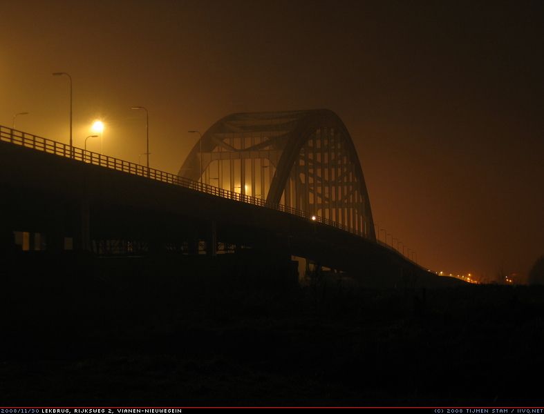
Lekbrug Vianen
|
|
Log in to activate viewing options
|
|
|
created by IIVQ
on 12/20/2008 10:37 PM
last modified by IIVQ
on 12/20/2008 11:39 PM
|
|
 |
Publically Viewable |
|
This location has been labeled by its creator as Public, and therefore can be viewed by anyone.
|
|
|
|
|
|
153 metre span over the river Lek. There might be some interesting features on the underside of the span - we didn't explore them.
|
|
|
Type: Bridge
Status: Abandoned
Accessibility: Easy
Recommendation: check it out if you're nearby
|
|
|
|
|
|
The bridge's main span is 153 meter, and it is 29 meter wide. The total bridge length is 532 meter.
On the brige you're not in view, as persons on the nearby active highway bridge can't see you.
|
|
|
|
|
|
|
|
|
This bridge was built in 1936. During the second world war, it was demolished. After the war, a temporary ship bridge was constructed, but this bridge got repaired and was reopenend in 1948.
This bridge ranked high in the traffic jam top-10, so it was decided to replace it by two new bridges, called "Jan Blankenbergbrug". The first one was ready in 1999, the second in 2006. They are allready planning a third span.
The foundation "Arch Bridge Vianen" tried to prevent the demolishment, first with the argument it was a monument, later that it was part of the state road plan of 1927 - just as the waalbrug near Zaltbommel - but in 2007 the highest court decided that the demolishing could go on.
At the same time, the regional transport authority thought it would be useful to convert it to a tram bridge, to connect Nieuwegein (north) with Vianen (south), but the upkeep costs of the bridge would be too high.
The wrecking will probably start in 2010 and finish in 2011.
|
|
|
|
|
The bridge will be demolished.
|
|
|
|
|
|
|
|
|
|
The moderator rating is a neutral rating of the content quality, photography, and coolness of this location.
This location has not yet been rated by a moderator.
|
|
 This location's validation is current. It was last validated by
Emperor Wang on 12/24/2008 4:15 PM.
This location's validation is current. It was last validated by
Emperor Wang on 12/24/2008 4:15 PM.
|
|
|
on Dec 24 08 at 16:15, Emperor Wang validated this location
on Dec 20 08 at 23:39, IIVQ made this location available
on Dec 20 08 at 23:39, IIVQ changed the following: History, Year Built, Year Closed, Interesting Features, Media Coverage, Description
on Dec 20 08 at 23:23, IIVQ updated gallery picture End of the road
on Dec 20 08 at 23:22, IIVQ updated gallery picture South
on Dec 20 08 at 23:21, IIVQ updated gallery picture Fog
on Dec 20 08 at 23:20, IIVQ updated gallery picture Dark Light
on Dec 20 08 at 23:18, IIVQ updated gallery picture Lines
on Dec 20 08 at 23:18, IIVQ updated gallery picture Majestic
on Dec 20 08 at 23:16, IIVQ updated gallery picture Overview
|
|
|
|
|
|
|
Is this location inappropriate / broken / missing key info?
If it's something you can fix, please scroll up and click the EDIT button.
If this location was only posted a few days ago, give the creator time to work on it.
Please try sending a message directly to the creator of the location. You'll find that info at the top of this page.
Otherwise, ONLY if you've already tried to contact the original creator,: Click here to notify an administrator.
|
|
|
|
All content and images copyright © 2002-2024 UER.CA and respective creators. Graphical Design by Crossfire.
To contact webmaster, or click to email with problems or other questions about this site:
UER CONTACT
View Terms of Service |
View Privacy Policy |
Server colocation provided by Beanfield
This page was generated for you in 93 milliseconds. Since June 23, 2002, a total of 738272767 pages have been generated.
|
|