|
|
|
UER Store
|
|
sweet UER decals:

|
|
|
 |
|
|
|
|
Location DB >
United States >
California >
Forestville >
Former CIA Radio Site
|
|
Log in to activate viewing options
|
|
|
 |
Publically Viewable |
|
This location has been labeled by its creator as Public, and therefore can be viewed by anyone.
|
|
|
|
|
|
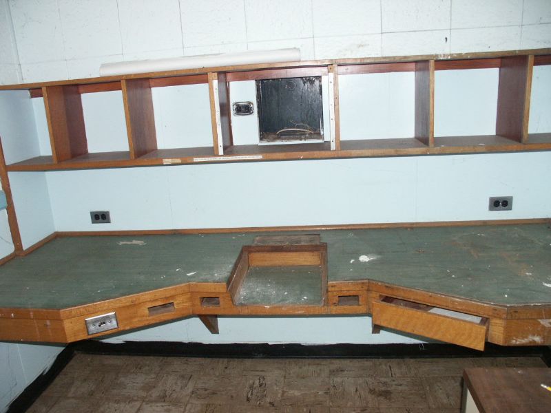
Approximately 600 acres atop a flattened hill, it was the perfect spot to hide a secret government radio site because pretty much nothing was visible from the surrounding land. The former CIA property now houses a Sonoma County Probation Dept work camp, a farm annex of Santa Rosa Junior College, and the former CIA FBIS building & immediate vicinity is now the Ya Ka Ama Tribe's Native American Plant Nursery & tribal grounds. These structures do seem to be of fairly modern, permanent construction, not WW-II era design, so I'm assuming CIA FBIS totally renovated the operation in the 1950s.
|
|
|
Type: Building
Status: Active
Accessibility: Easy
Recommendation: not very exciting
|
|
|
|
|
|
Nothing really, unless you have an interest in old radio or secretive federal gov't sites.
|
|
|
|
|
|
|
|
|
Specific details are somewhat murky, but this site seems to have started off as possibly a Federal Communications Commission Radio Intelligence Division ("RID") Secondary Monitoring Post during WW-II, the land being taken via condemnation process from the Wohler family, who had operated a farm there. An FCC RID Secondary Monitoring Post would have been used by FCC RID personnel to monitor the airwaves for enemy submarines operating off the Pacific Coast, and more importantly, detect & home-in on clandestine radio transmissions of spies or German/Japanese sympathizers sending radio transmissions from the Northern California region.
One local that lives near the site told me he'd heard it had been a secret Army "listening post" during WW-II, but the Army had a large radio intercept facility not too far away known as 'Two Rock Ranch' near Petaluma, which strengthens my believe this site was the FCC RID Secondary Monitoring Station that records list as being in/near Santa Rosa. FCC RID Secondary Monitoring Posts were shut down towards the end of WW-II.
From the 1950s until the late 1960s, or even perhaps shortly after the CIA was established in 1947, the site was owned & occupied by the CIA's Foreign Broadcast Information Service (FBIS), which monitored foreign shortwave broadcasts such as 'Radio Moscow' et. al & transcribed some of their broadcasts & forwarded the transcripts to CIA HQ so that analysts could get an understanding of what information (facts, commentary, & basic propaganda) foreign governments were broadcasting to the world via short-wave radio.
In the late 1960s, the CIA FBIS site was shut down & the land was supposed to be turned into an Office of Civil Defense (later known as FEMA) Federal Regional Center, a semi-hardened, secure federal gov't emergency operations center responsible for dealing with natural and human-caused (such as war) disasters. OCD never ended up building there FRC on the site, instead using old munitions bunkers at the former Naval Air Station Santa Rosa for their command & communication facilities, so the federal government finally got rid of the property in 1983, though the may have leased portions of it much earlier.
|
|
|
|
|
Beautiful hilltop land in an extremely expensive rural area -- anything is possible, though the deed from the federal gov't seems to require that the land be used by local gov't agencies for education, etc. purposes.
Ya Ka Ama Tribe does was to improve & expand their site, but they do not completely own the land yet.
|
|
|
|
|
|
|
|
|
|
The moderator rating is a neutral rating of the content quality, photography, and coolness of this location.
This location has not yet been rated by a moderator.
|
|
 This location's validation is current. It was last validated by
Emperor Wang on 11/17/2008 4:09 PM.
This location's validation is current. It was last validated by
Emperor Wang on 11/17/2008 4:09 PM.
|
|
|
on Nov 17 08 at 16:09, Emperor Wang validated this location
on Nov 17 08 at 7:07, /-/ooligan changed the following: History, Year Built, Year Closed, Web Links
on Mar 8 08 at 3:04, Emperor Wang validated this location
on Feb 25 08 at 6:58, /-/ooligan made this location available
on Feb 25 08 at 6:58, /-/ooligan changed the following: Latitude, Longitude, Web Links
on Feb 25 08 at 6:49, /-/ooligan updated the main picture
on Feb 25 08 at 6:48, /-/ooligan updated gallery My 2002 Visit -- Interior
on Feb 25 08 at 6:47, /-/ooligan updated gallery picture CB7
on Feb 25 08 at 6:47, /-/ooligan deleted picture 256819 from gallery My 2002 Visit -- Interior
on Feb 25 08 at 6:46, /-/ooligan updated gallery picture CB7
|
|
|
|
|
|
|
Is this location inappropriate / broken / missing key info?
If it's something you can fix, please scroll up and click the EDIT button.
If this location was only posted a few days ago, give the creator time to work on it.
Please try sending a message directly to the creator of the location. You'll find that info at the top of this page.
Otherwise, ONLY if you've already tried to contact the original creator,: Click here to notify an administrator.
|
|
|
|
All content and images copyright © 2002-2024 UER.CA and respective creators. Graphical Design by Crossfire.
To contact webmaster, or click to email with problems or other questions about this site:
UER CONTACT
View Terms of Service |
View Privacy Policy |
Server colocation provided by Beanfield
This page was generated for you in 109 milliseconds. Since June 23, 2002, a total of 739071194 pages have been generated.
|
|