|
|
|
UER Store
|
|
sweet UER decals:

|
|
|
|
Activity
|
|
549 online
Server Time:
2024-04-23 17:43:51
|
|
|
 |
|
|
|
|
Location DB >
United States >
California >
Death Valley >
Owl Hole Springs Mining Area
|
|
Owl Hole Springs Mining Area
|
|
|
Log in to activate viewing options
|
|
|
created by rapcw
on 6/1/2007 2:14 AM
last modified by fr00tCake
on 10/24/2022 8:45 PM
|
|
 |
Publically Viewable |
|
This location has been labeled by its creator as Public, and therefore can be viewed by anyone.
|
|
|
|
|
|
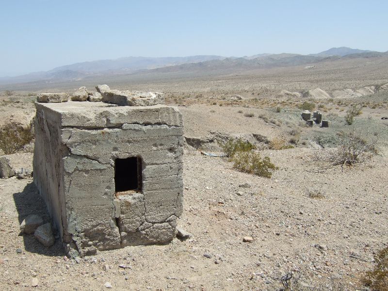
An iron mining area consisting of the Black Magic and New Deal mines and ruins around Owl Hole Springs.
|
|
|
Type: Outdoors
Status: Abandoned
Accessibility: Moderate
Recommendation: check it out if you're nearby
|
|
|
|
rust
unsafe flooring
Burros
|
|
|
Owl Hole Springs and the various ruins around there, the sites of the Black Magic and New Deal mines.
|
|
|
about 30 miles of rough dirt roads
|
|
|
|
flashlight
binoculars
head protection
Water
|
|
|
|
In February 1910 a prospector named Alex Yeoman discovered a large low-grade manganese (iron oxide) deposit north of Owl Hole Spring, which he named the Owls Head or Owl Hole Mine. Due to its remote location and low quality ore, the mine wouldn't pay until World War One brought a surge in demand for iron. After hostilities broke out in 1914, Yeoman began working the mine and constructed a road east across the southern end of Death Valley to the nearest Tonopah & Tidewater siding at Riggs, to which ore was hauled by two caterpillar tractors. Even at boom prices however, the ore averaged only $35 a ton, and the mine was a minor and sporadic producer from its first shipment in 1915 until it was forced to shut down from price declines following the end of the war, shipping about 3,000 tons overall. During World War Two, the mine again became active, shipping 12,000 tons between 1941 and 1946 before ceasing production for good.
Other manganese mines were worked along side the Owls Head during periods of high prices. The nearby New Deal Mine produced about 4,000 tons between 1916 and 1956, and the Black Magic mine operated sporadically from 1942 to 1958. Production in the area ceased after that, and in 1994 the Owl Hole Springs mining area became part of the new Death Valley National Park.
|
|
|
|
|
|
|
|
|
|
|
|
|
The moderator rating is a neutral rating of the content quality, photography, and coolness of this location.
This location has not yet been rated by a moderator.
|
|
 This location's validation is current. It was last validated by
Emperor Wang on 10/25/2022 2:25 PM.
This location's validation is current. It was last validated by
Emperor Wang on 10/25/2022 2:25 PM.
|
|
|
on Oct 25 22 at 14:25, Emperor Wang validated this location
on Oct 24 22 at 20:45, fr00tCake changed the following: Latitude, Longitude, Co-ordinate Accuracy, Prefer Satellite
on Oct 9 07 at 1:03, Emperor Wang validated this location
on Oct 8 07 at 1:34, rapcw changed the following: History
on Oct 8 07 at 1:24, rapcw made this location available
on Oct 7 07 at 3:07, rapcw changed the following: History
on Oct 7 07 at 3:03, rapcw changed the following: History, Interesting Features, Security Measures, Required Equipment, Description
on Aug 23 07 at 23:16, rapcw updated gallery Memorial Day Weekend
on Aug 23 07 at 23:15, rapcw updated gallery Memorial Day Weekend
on Aug 23 07 at 23:14, rapcw updated gallery picture Burros
|
|
|
|
|
|
|
Is this location inappropriate / broken / missing key info?
If it's something you can fix, please scroll up and click the EDIT button.
If this location was only posted a few days ago, give the creator time to work on it.
Please try sending a message directly to the creator of the location. You'll find that info at the top of this page.
Otherwise, ONLY if you've already tried to contact the original creator,: Click here to notify an administrator.
|
|
|
|
All content and images copyright © 2002-2024 UER.CA and respective creators. Graphical Design by Crossfire.
To contact webmaster, or click to email with problems or other questions about this site:
UER CONTACT
View Terms of Service |
View Privacy Policy |
Server colocation provided by Beanfield
This page was generated for you in 46 milliseconds. Since June 23, 2002, a total of 738814965 pages have been generated.
|
|