|
|
|
UER Store
|
|
 order your copy of Access All Areas today!
|
|
|
|
Activity
|
|
606 online
Server Time:
2024-04-23 22:55:54
|
|
|
 |
|
|
|
|
Location DB >
United States >
Tennessee >
Oak Ridge >
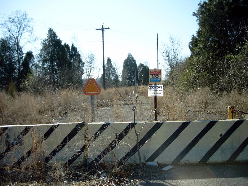
Route 58 Bridge Remains
|
|
Log in to activate viewing options
|
|
|
created by camarochic007
on 1/26/2006 9:56 PM
last modified by nootz
on 11/28/2007 12:12 AM
|
|
 |
Publically Viewable |
|
This location has been labeled as Demolished, and therefore can be viewed by anyone.
|
|
|
|
|
|
|
|
Type: Outdoors
Status: Demolished
Accessibility: Easy
Recommendation: check it out if you're nearby
|
|
|
|
|
|
This is about a quarter mile from the now defunct k-25 site, where DOE processed nuclear material until 1985. Now the government is trying to clean up the site and rent it out to civilian run businesses. Good luck trying that one.
|
|
|
|
|
|
|
|
|
The bridge that used to stand here was hurriedly built in the mid 1940's for the top secret Manhattan Project. It has since been rebuilt twice.
|
|
|
|
|
|
|
|
|
|
|
|
|
The moderator rating is a neutral rating of the content quality, photography, and coolness of this location.
This location has not yet been rated by a moderator.
|
|
 This location's validation is current. It was last validated by
Emperor Wang on 11/28/2007 12:34 AM.
This location's validation is current. It was last validated by
Emperor Wang on 11/28/2007 12:34 AM.
|
|
|
on Nov 28 07 at 0:34, Emperor Wang validated this location
on Nov 28 07 at 0:12, nootz changed the following: Latitude, Longitude
on Apr 13 06 at 22:39, Emperor Wang validated this location
on Feb 1 06 at 1:03, camarochic007 made this location private
on Jan 27 06 at 1:32, camarochic007 swapped pictures 4 and 5
on Jan 27 06 at 0:49, camarochic007 updated gallery picture SIMG0120
on Jan 26 06 at 23:17, camarochic007 made this location public
on Jan 26 06 at 23:17, camarochic007 made this location available
on Jan 26 06 at 23:17, camarochic007 changed the following: Interesting Features
on Jan 26 06 at 23:14, camarochic007 swapped pictures 14 and 15
|
|
|
|
|
|
|
Is this location inappropriate / broken / missing key info?
If it's something you can fix, please scroll up and click the EDIT button.
If this location was only posted a few days ago, give the creator time to work on it.
Please try sending a message directly to the creator of the location. You'll find that info at the top of this page.
Otherwise, ONLY if you've already tried to contact the original creator,: Click here to notify an administrator.
|
|
|
|
All content and images copyright © 2002-2024 UER.CA and respective creators. Graphical Design by Crossfire.
To contact webmaster, or click to email with problems or other questions about this site:
UER CONTACT
View Terms of Service |
View Privacy Policy |
Server colocation provided by Beanfield
This page was generated for you in 312 milliseconds. Since June 23, 2002, a total of 738841096 pages have been generated.
|
|