|
|
|
UER Store
|
|
sweet UER decals:

|
|
|
 |
|
|
|
|
Location DB >
Mexico >
Quintana Roo >
Valladolid >
Chichen Itza
|
|
Log in to activate viewing options
|
|
|
created by lopix
on 7/28/2005 1:39 AM
last modified by lopix
on 7/30/2005 4:14 PM
|
|
 |
Publically Viewable |
|
This location has been labeled by its creator as Public, and therefore can be viewed by anyone.
|
|
|
|
|
|
El Castillo - The massive Kukulcán pyramid called "El Castillo" (the castle) is roughly at the center of the site. Climbing it is quite a challenge and those who make it are rewarded with a spectacular view of the city and surrounding country side. A trip inside the pyramid is quite the opposite. The dark, unbearably humid corridors and chambers are too much for some people.
Early morning, before the onslaught of tourists, Chichén Itzá is a magical place. Being able to wander around the site for two hours before the gates were opened and watching the massive pyramid take shape through the lifting fog is an experience not soon forgotten.
The construction of the Kukulcán Pyramid at Chichén Itzá was planned so that each Vernal Equinox the dying sun would cast a shadow of a serpent writhing down the steps of the pyramid. Every year over 40,000 people make the trek to the great pyramid to watch in awe as the snakes diamond backed body slowly appears.
If you stand facing the foot of the temple and shout the echo comes back as a piercing shriek. Also, a person standing on the top step can speak in a normal voice and be heard by those at ground level for some distance. This quality is also shared by another Mayan pyramid at Tikal.
The Ball Court - The Mayans were great sportsmen and build huge ballcourts to play their games. The Great Ballcourt of Chichén Itzá is 545 feet long and 225 feet wide overall. It has no vault, no discontinuity between the walls and is totally open to the sky.
Each end has a raised "temple" area. A whisper from end can be heard clearly at the other end 500 feet away and through the length and breath of the court. The sound waves are unaffected by wind direction or time of day/night. Archaeologists engaged in the reconstruction noted that the sound transmission became stronger and clearer as they proceeded. In 1931 Leopold Stokowski spent 4 days at the site to determine the acoustic principals that could be applied to an open-air concert theater he was designing. Stokowski failed to learn the secret. To this day it has not been explained.
It is not hard to imagine a Mayan King sitting here presiding over the games. Legends say that the the winning captain would present his head to the losing captain, who then decapitates him. While this may seem a strange reward, the Mayans believed this to be the ultimate honor. The winning captain getting a direct ticket to heaven instead of going through the 13 steps that the Mayans believed they had to go through in order to reach heaven.
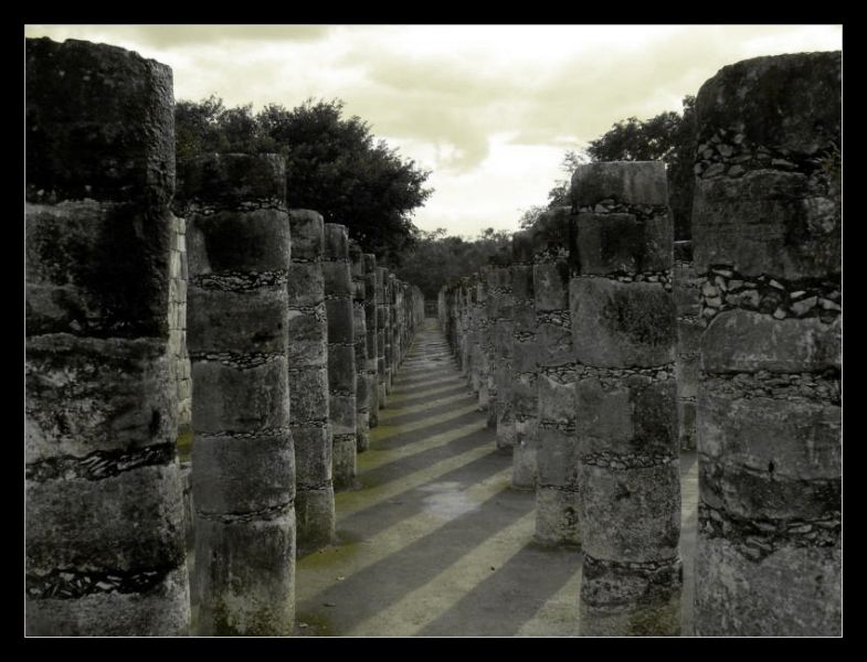
The Temple of the Warriors and its adjacent Temple of the Jaguar are the most awe inspiring ruins on the complex. A massive temple structure, surrounded by hundreds of columns (some call it the Temple of 10,000 Columns) is carved with reliefs. The columns continue on into the jungle, that part of the temple still has not been restored. It's an unsettling sight to see how easily the forest has reclaimed the area. What unanswered questions lay under the canopy of leaves and beneath the twisted roots?
The Observatory - The intense interest of the Maya in the annual travels of the sun across the sky is evident in many structures at Chichén Itzá and other Mayan Sites. South of the Castillo is a strange round building known as the Carocal. Several of its windows point towards the equinox sunset and the southernmost and northernmost points on the horizon where Venus rises.
The Nunnery - The Nunnery, in the southern group of ruins, contains some of the best preserved structures at Chichén Itzá. They appear to be the living quarters of the elite Mayans. Every square foot of wall has reliefs and paintings decorating it.
|
|
|
Type: Ruins
Status: Active
Accessibility: Easy
Recommendation: worth the trip
|
|
|
|
|
|
The Castillo
The Ossuary
The Church
The Nunnary
Observatory
The Ball Court
Platform of Skulls
Platform of Eagles & Jaguars
Platform of Venus
Sacred Cenote
Temple of the Warriors
Plaza of the Thousand Columns
|
|
|
fences
part-time guard
locked gates
zealous security
|
|
|
|
|
|
|
Deep within the jungles of Mexico and Guatemala and extending into the limestone shelf of the Yucatan peninsula lie the mysterious temples and pyramids of the Maya. While Europe was still in the midst of the Dark Ages, these amazing people had mapped the heavens, evolved the only true writing system native to the Americas and were masters of mathematics. They invented the calendars we use today. Without metal tools, beasts of burden or even the wheel they were able to construct vast cities across a huge jungle landscape with an amazing degree of architectural perfection and variety. Their legacy in stone, which has survived in a spectacular fashion at places such as Palenque, Tikal, Tulum, Chichén Itzá, Copan and Uxmal, lives on as do the seven million descendants of the classic Maya civilization.
The Maya are probably the best-known of the classical civilizations of Mesoamerica. Originating in the Yucatan around 2600 B.C., they rose to prominence around A.D. 250 in present-day southern Mexico, Guatemala, northern Belize and western Honduras. Building on the inherited inventions and ideas of earlier civilizations such as the Olmec, the Maya developed astronomy, calendrical systems and hieroglyphic writing. The Maya were noted as well for elaborate and highly decorated ceremonial architecture, including temple-pyramids, palaces and observatories, all built without metal tools. They were also skilled farmers, clearing large sections of tropical rain forest and, where groundwater was scarce, building sizable underground reservoirs for the storage of rainwater. The Maya were equally skilled as weavers and potters, and cleared routes through jungles and swamps to foster extensive trade networks with distant peoples.
Around 300 B.C., the Maya adopted a hierarchical system of government with rule by nobles and kings. This civilization developed into highly structured kingdoms during the Classic period, A.D. 200-900.
Their society consisted of many independent states, each with a rural farming community and large urban sites built around ceremonial centers. It started to decline around A.D. 900 when - for reasons which are still largely a mystery - the southern Maya abandoned their cities. When the northern Maya were integrated into the Toltec society by A.D. 1200, the Maya dynasty finally came to a close, although some peripheral centers continued to thrive until the Spanish Conquest in the early sixteenth century.
Chichén Itzá, the ancient city whose name means "in the mouth at the Itzáe's Well", was, in its time of grandeur (between 800 and 1200 A.D.), the centre of political, religious and military power in Yucatán, if not all of South-eastern Meso America.
In its architecture one can observe a gradual change in style, starting with the Puuc style, also shared with Uxmal and other sites in the Penninsula and cluminating with the so-called Mayan Toltec style, due to the architectural similiarities with Tula, capital of the Ancient Toltecs, and with other sites in Central Mexico, such as Oaxaca and the Gulf Coast.
Chichén Itzá was a large city with a great many inhabitants, distributed around the architectural nucleii which we observe as ruins, who had a relatively easy access to the water coming from the various caves and Cenotes of the region.
The city is divided into two principal areas: Chichén Viejo (Old Chichén) and Chichén Nuevo (New Chichén). Click on the green image to see sample illustrations of each of the two areas.
Chichén Viejo was founded about 400 A.D. by the Maya and governed by priests. Here the architecture is characterized by many representations of the god Chaac, the Maya rain god.
Chichén Nuevo began about 850 A.D. with the arrival of the Itzá from Central Mexico. The city was rebuilt by the Itzá and is charactorized by images of the god Kukulcán, the plumed serpent. Around 1150 A.D. a new wave of Itzá took over the city and ruled for another 150 years until Chichén Itzá was finally overtaken by the rival city of Mayapan.
The Itzá were politically and commercially more aggressive than the earlier Maya rulers and the city's history under their rule was marked by many bloody battles.
Chichén Itzá was abandoned suddenly around 1400 A.D. perhaps because of internal fighting or for lack of food. There are many theories but nobody knows for certain.
|
|
|
|
|
|
|
|
|
|
|
|
|
The moderator rating is a neutral rating of the content quality, photography, and coolness of this location.
This location has not yet been rated by a moderator.
|
|
|
on Feb 16 09 at 15:29, ActionSatisfaction Esq. validated this location
on Feb 4 09 at 4:21, critter updated gallery picture Sacrifice for Kukulcán
on Feb 4 09 at 4:18, critter added some pictures to a gallery
on Feb 4 09 at 4:10, critter created a new gallery
on May 16 07 at 13:42, SaraBellum validated this location
on Jul 30 05 at 16:14, lopix changed the main information
on Jul 28 05 at 2:21, lopix made this location available
on Jul 28 05 at 2:21, lopix updated a gallery picture
on Jul 28 05 at 2:21, lopix updated a gallery picture
on Jul 28 05 at 2:21, lopix updated a gallery picture
|
|
|
|
|
|
|
Is this location inappropriate / broken / missing key info?
If it's something you can fix, please scroll up and click the EDIT button.
If this location was only posted a few days ago, give the creator time to work on it.
Please try sending a message directly to the creator of the location. You'll find that info at the top of this page.
Otherwise, ONLY if you've already tried to contact the original creator,: Click here to notify an administrator.
|
|
|
|
All content and images copyright © 2002-2024 UER.CA and respective creators. Graphical Design by Crossfire.
To contact webmaster, or click to email with problems or other questions about this site:
UER CONTACT
View Terms of Service |
View Privacy Policy |
Server colocation provided by Beanfield
This page was generated for you in 140 milliseconds. Since June 23, 2002, a total of 739123331 pages have been generated.
|
|