|
|
|
UER Store
|
|
 order your copy of Access All Areas today!
|
|
|
|
Activity
|
|
525 online
Server Time:
2024-04-20 14:46:15
|
|
|
 |
|
|
|
|
Location DB >
Greece >
Attica >
Athens >
Galatsi Limekiln
|
|
Log in to activate viewing options
|
|
|
 |
Publically Viewable |
|
This location has been labeled by its creator as Public, and therefore can be viewed by anyone.
|
|
|
|
|
|
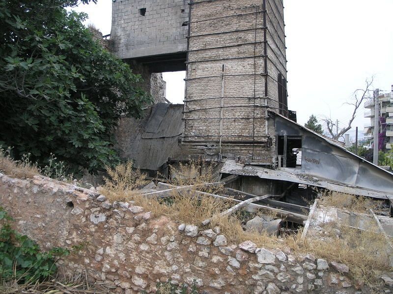
The small complex includes the kiln itself, with a wide brick chimney, firing chamber and a rusted catwalk, the remains of a large pump and crane, a storage silo for quicklime, belts for feeding limestone and fuel, and a set of rails that must have led to the quarry wall once. There was a small office, and storage areas. All have collapsed.
The complex follows the contour of the hill and takes advantage of it very nicely. Limestone was quarried at the top of the hill, then carted to the feeding chute, maybe 10 metres (30 feet) from the rest of the complex. There were two feed mechanisms: mining carts on rails must have been the original one. At some point, the quarry must have become less productive, or quarrying was prohibited on the hills (they're protected now). The company then scrapped the rails system and built a ramp with a belt so that lorries could bring limestone from other quarries.
The remnants of both systems can still be seen. The ramp is clearly blocking the rails, which is why I assume it was later.
Above the pump/engine room, a massive, strangely shaped fuel tank is visible. It's rusted through and full of holes. Next to it, a vehicle inspection ramp that is still used today: bastard lorry drivers use it to dump their engine oil.
Next to that, the remains of a small crane. Rusted through, like everything else, with the engine (and everything salvageable) removed.
A few metres below that is a huge pump that would probably have driven the belts too. The pump room itself has been scavenged. The massive diesel engine that drove everything on site has been removed, the drive axle cut.
In fact, everything is in a very bad state. There's very little graffiti though, and I find that surprising given the proximity to Grava. As I took photos, I was eyed by a few basketball-playing kids below.
By the way, I've never seen more hypodermic needles on a site, especially the top, where the limestone feeding chute is. Be careful walking around there.
|
|
|
Type: Building
Status: Abandoned
Accessibility: Easy
Recommendation: worth the trip
|
|
|
|
rust
unsafe flooring
hypodermic needles, the most feared high-schoolers in Athens, garbage, illegally dumped engine oil
|
|
|
The kiln itself with its half-collapsed brick chimney. The remains of two feed belts, the rusted catwalk and maze of pipes around the kiln. The huge iron wheel of the pump in the engine room.
|
|
|
|
|
|
gloves
long pants / sleeves
towelettes
|
|
|
Rope if you want to climb to the catwalk (not recommended)
|
|
|
This part of Athens is known as Galatsi. It's now a hilly residential area famous for 'Grava', a massive (7,000 students in the early Nineties) and infamous school complex, home to the most feared school 'children' in town, and a name whispered at night to frighten children. 'Eat your soup or you get to go to Grava when you're old enough'.
At one point, though, this was a sparsely built area. The hills, known as Turk Mountains ('Tourkovounia'), are rich in limestone. There were lots of quarries on them. This one was no exception. The hill, overlooking a part of the city that doesn't make it to the postcards and TV shows, is a disused quarry with a decaying limekiln, probably from the 1930s.
Most of the quarries on these hills either went out of business, or stopped operating when the limestone ran out. The hills themselves are protected these days. Topsoil is being put back on them, and they're planted to provide much-needed parks to the area.
|
|
|
|
|
The hill doesn't lend itself to development, although there was talk of building a(nother) school on it. Most likely, and like other similar hill quarries in the area, it'll be converted to a park at some point.
|
|
|
|
|
|
|
|
|
|
The moderator rating is a neutral rating of the content quality, photography, and coolness of this location.
This location has not yet been rated by a moderator.
|
|
 This location's validation is current. It was last validated by
Emperor Wang on 12/7/2006 7:32 PM.
This location's validation is current. It was last validated by
Emperor Wang on 12/7/2006 7:32 PM.
|
|
|
on Dec 7 06 at 19:32, Emperor Wang validated this location
on Dec 6 06 at 22:54, SoupMeister changed the following: Latitude, Longitude, Co-ordinate Accuracy
on Aug 28 05 at 9:51, SoupMeister changed the following: Prefer Satellite
on May 23 05 at 19:12, SoupMeister updated a gallery picture
on May 20 05 at 7:55, SoupMeister updated a gallery picture
on May 19 05 at 22:24, SoupMeister updated a gallery picture
on May 19 05 at 14:55, SoupMeister changed the main information
on May 19 05 at 14:48, SoupMeister updated a gallery picture
on May 19 05 at 14:47, SoupMeister updated a gallery picture
on May 19 05 at 14:37, SoupMeister made this location available
|
|
|
|
|
|
|
Is this location inappropriate / broken / missing key info?
If it's something you can fix, please scroll up and click the EDIT button.
If this location was only posted a few days ago, give the creator time to work on it.
Please try sending a message directly to the creator of the location. You'll find that info at the top of this page.
Otherwise, ONLY if you've already tried to contact the original creator,: Click here to notify an administrator.
|
|
|
|
All content and images copyright © 2002-2024 UER.CA and respective creators. Graphical Design by Crossfire.
To contact webmaster, or click to email with problems or other questions about this site:
UER CONTACT
View Terms of Service |
View Privacy Policy |
Server colocation provided by Beanfield
This page was generated for you in 125 milliseconds. Since June 23, 2002, a total of 738604954 pages have been generated.
|
|