|
|
|
UER Store
|
|
sweet UER decals:

|
|
|
 |
|
|
|
|
Location DB >
Canada >
Ontario >
Foymount >
CFB Foymount
|
|
Log in to activate viewing options
|
|
|
created by Mutt
on 7/12/2004 10:51 PM
last modified by Ricky_from_TV
on 8/17/2015 1:40 AM
|
|
 |
Publically Viewable |
|
This location has been labeled by its creator as Public, and therefore can be viewed by anyone.
|
|
|
|
|
|
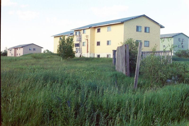
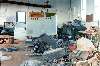
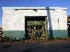
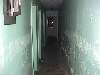
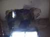
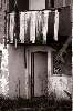
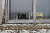
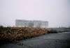
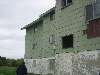
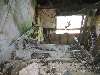
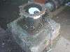
Basically a small town on the summit of a mountain. Formerly a RCAF radar station, now mosty abandoned. The PMQ's are, for the most part, still occupied. There are five apartment buildings, open to the elements since 1974, watch for crappy flooring inside, and don't even think of standing on the wooden balconies! The school is a bit tougher to enter as it is within the residential area. The mess halls are now used by a company that makes outdoor clothing, but they too look rundown.
A must see is what I call FoyHenge. The foundations on the top of the 'mountain' of the radar domes and adjoining buildings. While up there, take the time to watch the sun set its awesome.
|
|
|
Type: Buildings
Status: Partially Active
Accessibility: Moderate
Recommendation: check it out if you're nearby
|
|
|
|
asbestos
rust
unsafe flooring
Variable hazards depending upon building entered.
|
|
|
Multiple apartment buildings, a school, and military base support buildings abandoned since 1974. Basicaly a whole miltary base.
UPDATE: Only the Erie apartment block was easily accessible as of May 2007 with the others being sealed tight.
Another update: The western-most apartment building has actually been renovated, and is now lived in. Went up a few weeks ago to do some night photography and the lower two levels of the building were lit up... with people inside.
|
|
|
wooden boarding
Small town, the locals notice foreigners. Act accordingly. Be particulary careful during deer hunting season. Yes, I'm being serious!
|
|
|
|
flashlight
breathing mask
gloves
Camera and a friend
|
|
|
|
The Pinetree Line was first conceived during the Cold War when fears of a Soviet air attack against North America were running high. In the late 1940s, U.S. and Canadian defence chiefs put their heads together and developed joint defence plans which included a series of 33 prime radar stations stretching from coast to coast across Canada.
Construction on the radar stations began in the late 1940s. For the most part, they were developed to detect incoming Soviet aircraft and direct interceptor aircraft to other points within their area of coverage. Wherever possible, each station was located on the highest point of land within its jurisdiction, usually a hill or mountain top.
RCAF Station Foymount was built in 1950. Located on the historic Opeongo Road, atop the Opeongo Mountains in Renfrew County, the operations building towered 1800 feet above sea level. In addition to the radomes, receiving and transmitting equipment, and the usual combined mess, quarters and maintenance buildings, the station included 65 houses, a school, medical and dental facilities, a recreation room with a gym, swimming pool, general store, post office and a host of other amenities. Water was supplied from a 100,000 gal. reservoir, which drew its source from a nearby lake. Sewage was treated in a plant located right on the premises. In effect, the station was a fully self-contained and self supporting community with all the facilities one would expect to find in any similarly sized civilian village. Initial personnel estimates were 38 officers and 343 mixed ranks and civilians.
RCAF Station Foymount became fully operational in September 1952. In May 1953 the 32 Aircraft Control and Warning Squadron moved in to assume the Ground Control Intercept role. By 1963 computer technology had advanced to the point where interceptors were automated and controlled directly from Ottawa. Station Foymount was upgraded to intruder-detection only and the unit was renamed the 32 Radar Squadron.
The unification of the Canadian Armed Forces in 1967 resulted in more reshuffling and re-designation of ranks, roles and titles. By 1968, the station was operating as a long range radar facility and field training school and no longer assumed any Norad functions. In 1970 a total of 208 military and civilian personnel were assigned to the station.
Military downsizing in the early 1970s led to the eventual closure of CFS Foymount. After it was determined the radars at CFS Falconbridge and CFS Lac St. Denis were powerful enough to cover Foymount's existing territory, it was decided to close the Foymount station in October 1974. The radar towers and operations centre were dismantled and the remaining buildings sold. The buyer later defaulted on his property taxes and many of the buildings were repossessed by the township for outstanding tax arrears.
Today, Foymount is slowly coming back to life. Although many of the buildings remain abandoned, several are now leased to such tenants as Sebastopol Township and the Black Water Factory, a manufacturer of high quality outerwear. A tea room has recently opened.
The houses were put up for sale, some for as little as the cost of the unpaid taxes, and many are now owned by retired military personnel who were formerly stationed in Foymount.
Although Foymount still contains a number of ruins, the new residents are not ready to see their community die. Many of occupied homes have been renovated and repaired and their owners appear eager to recapture the strong social and community ties they enjoyed during Foymount's military hey day.
Copy from http://www.ghosttownpix.com/
ADDENDUM: The 5 apartment buildings were sold by the township to a private individual for $10,000 within the last few years. There appears to be some attempt at occupying portions of the Cree block as there are extra "No Trespassing" signs here and pictures of Jesus in some windows.
Purportedly the township was desperate to dispose of the buildings- a proposal to burn them down was made and then rejected due to the presence of asbestos. The new owners apparently must deal with the asbestos problem as well, making any real progress on renovating these buildings very costly.
|
|
|
|
|
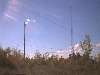
Apartment buildings will eventually return to nature. The radar dome areas are now used heavily by various communication companies antenna towers.
UPDATE: One of the apartments has been fixed up, and is currently occupied. Yes. Really.
|
|
|
|
|
|
|
http://www.pinetreeline.org/
The homepage for Canada's Pinetree Line Radar stations of the cold war. The site has information on the rest of the Pintree Line stations and many many images from the past to the present.
|
|
|
|
The moderator rating is a neutral rating of the content quality, photography, and coolness of this location.
| Category |
Rating |
| Photography |
10 / 10 |
| Coolness |
10 / 10 |
| Content Quality |
10 / 10 |
|
|
 This location's validation is current. It was last validated by
Mike Dijital on 8/17/2015 11:35 AM.
This location's validation is current. It was last validated by
Mike Dijital on 8/17/2015 11:35 AM.
|
|
|
on Aug 17 15 at 11:35, Mike Dijital validated this location
on Aug 17 15 at 1:40, Ricky_from_TV changed the following: Status, Recommended Equipment
on Jul 16 15 at 15:15, Mike Dijital validated this location
on Jul 16 15 at 3:52, bandi updated gallery Bandi/fun_and_games/Rodentia RattBurg's June 16th midnight trip
on Jul 16 15 at 3:52, bandi updated gallery Bandi/fun_and_games/Rodentia RattBurg's June 16th midnight trip
on Sep 23 09 at 3:17, Emperor Wang validated this location
on Sep 21 09 at 19:55, bandi changed the following: Accessibility, Interesting Features, Recommendation, Future Plans
on Aug 7 08 at 14:20, Mutt validated this location
on Aug 7 08 at 14:19, Mutt made this location public
on Aug 7 08 at 14:19, Mutt changed the following: City
|
|
|
|
|
|
|
Is this location inappropriate / broken / missing key info?
If it's something you can fix, please scroll up and click the EDIT button.
If this location was only posted a few days ago, give the creator time to work on it.
Please try sending a message directly to the creator of the location. You'll find that info at the top of this page.
Otherwise, ONLY if you've already tried to contact the original creator,: Click here to notify an administrator.
|
|
|
|
All content and images copyright © 2002-2024 UER.CA and respective creators. Graphical Design by Crossfire.
To contact webmaster, or click to email with problems or other questions about this site:
UER CONTACT
View Terms of Service |
View Privacy Policy |
Server colocation provided by Beanfield
This page was generated for you in 593 milliseconds. Since June 23, 2002, a total of 739069544 pages have been generated.
|
|