|
|
|
UER Store
|
|
 order your copy of Access All Areas today!
|
|
|
|
Activity
|
|
637 online
Server Time:
2024-04-19 00:49:35
|
|
|
 |
|
|
|
|
Location DB >
United States >
Alabama >
Huntsville >
3 Caves Quarry
|
|
Log in to activate viewing options
|
|
|
created by SnArF
on 4/27/2004 8:02 PM
last modified by Avatar-X
on 3/6/2013 6:59 PM
|
|
 |
Publically Viewable |
|
This location has been labeled by its creator as Public, and therefore can be viewed by anyone.
|
|
|
|
|
|
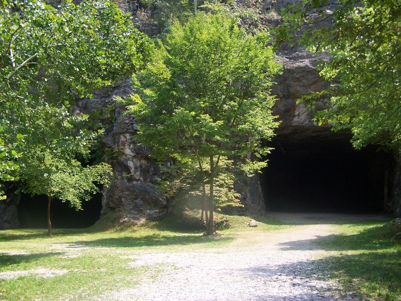
A man made cave stretching back in to Monte-Sano Wilderness about a mile back.
|
|
|
Type: Underground
Status: Closed
Accessibility: Difficult
Recommendation: check it out if you're nearby
|
|
|
|
water
Fence/Rattlesnakes and Heights
|
|
|
It is not safe to hike in. LARGE (car size) rocks continue to fall.
(Despite your personal experience, this is a man-made quarry and is very fragile. Drought conditions in 2005 and 2006 dried out the watertable and made the ceiling very unstable.)
3 caves has 40+ foot ceilings, it was mined out a while back. Beware of Rattlesnakes and other wildlife. There are many features here that natural caves have. Several suicides and accidental deaths have also occurred around the entrance area. Going alone at night is not recommended.
|
|
|
fences
locked gates
Neighborhood by Entrance
|
|
|
|
flashlight
long pants / sleeves
|
|
|
|
This was an old Limestone Quarry in the late 40's to early 50's. It is an extremely interesting site. I have been down in the Caves here several times, and my dad even went through him when he was growing up. He's the one that told me about them. That said, heres more info:
------------------
Three caves gets its name from three large obvious openings out of the old Hermitage Quarry. However, three caves is not a true cave and has four, not three entrances. The three entrances that give its name are visible in a large open pit. The fourth entrance is off to the south and is actually a collapse of the roof.
The quarry was begun in 1945 to mine limestone, the rock that forms Monte Sano. The rock was crushed and used as gravel, as well as, when ground finer, to make Portland Cement.
The 'cave' extends by way of a room and pillar type mine for about 10 acres under the western slope of Monte Sano.
As Huntsville expanded, the dust from the crushing operation and the heavy truck traffic passing through a growing neighborhood caused the operation to shut down in 1955.
Although it is not a natural cave, Three caves has many of the attributes of a natural cave, there is absolutely no light.
At one point, one can see where the excavation breached a real cave. High on one wall, you can see where what once was a cave has been intersected by the quarry.
[There is a] small passage that carries a little wet weather stream, as many caves do. However, this stream can no longer go on to exit the mountain as a spring, as it once did, since the remainder of the passage has been removed by excavation. The stream now flows down the wall of the quarry. In doing so, it deposits tavertine, just as water does in natural caves. Tavertine is calcium carbonate or calcite, the principal component in limestone. Rainwater is charged with carbon dioxide making it a weak carbonic acid. As it percolates down it dissolves some of the limestone. The solutional process is what hollows out natural caves in the first place. But now as this stream emerges into the air of the quarry, the carbon dioxide leaves the water. Deprived of its acid, the water can no longer hold its dissolved calcite, which is deposited as precipitate. Speologists give names to the form of these rocky deposits take such as stalagtites and stalagmites, etc. In Three Caves, it takes the form of rimstone dams or gours, which are also common in real caves.
Today, the land trust of Huntsville and North Alabama owns Three caves as part of their Monte Sano Land Preserve and hiking trails. Visit their websites at www.landtrust-hsv.org
Information taken from "Tales of Huntsville Caves"by William W. Varnedoe Jr. and Charles A. Lundquist of the Huntsville National Speological Society
|
|
|
|
|
None known yet, tours were stopped in 2007. Its a Nature Preserve, so nobody will be demolishing this or using it for anything else.
|
|
|
|
|
|
|
|
|
|
The moderator rating is a neutral rating of the content quality, photography, and coolness of this location.
| Category |
Rating |
| Photography |
5 / 10 |
| Coolness |
5 / 10 |
| Content Quality |
7 / 10 |
|
|
 This location's validation is current. It was last validated by
Opheliaism on 3/7/2013 3:44 AM.
This location's validation is current. It was last validated by
Opheliaism on 3/7/2013 3:44 AM.
|
|
|
on Mar 7 13 at 3:44, Opheliaism validated this location
on Mar 6 13 at 18:59, Avatar-X changed the following: Owner, Web Links
on Mar 6 13 at 17:07, Avatar-X changed the following: Status, Accessibility, Interesting Features, Required Equipment, Future Plans
on May 13 12 at 18:07, Opheliaism validated this location
on May 13 12 at 3:45, SnArF changed the following: Status, Accessibility, Required Equipment
on Apr 15 10 at 1:09, Steed validated this location
on Apr 14 10 at 21:05, washthat changed the following: Latitude, Longitude, Co-ordinate Accuracy, Prefer Satellite
on Oct 5 09 at 15:50, Opheliaism validated this location
on Mar 24 06 at 23:23, Emperor Wang validated this location
on Mar 24 06 at 5:14, SnArF changed the following: Co-ordinate Accuracy, History, Year Closed, Interesting Features, Security Measures, Required Equipment, Web Links
|
|
|
|
|
|
|
Is this location inappropriate / broken / missing key info?
If it's something you can fix, please scroll up and click the EDIT button.
If this location was only posted a few days ago, give the creator time to work on it.
Please try sending a message directly to the creator of the location. You'll find that info at the top of this page.
Otherwise, ONLY if you've already tried to contact the original creator,: Click here to notify an administrator.
|
|
|
|
All content and images copyright © 2002-2024 UER.CA and respective creators. Graphical Design by Crossfire.
To contact webmaster, or click to email with problems or other questions about this site:
UER CONTACT
View Terms of Service |
View Privacy Policy |
Server colocation provided by Beanfield
This page was generated for you in 156 milliseconds. Since June 23, 2002, a total of 738451760 pages have been generated.
|
|