
|
mastershakes
  
location:
sioux falls, SD
Gender: Male

For only in the grip of darkness will we shine amidst the brightest stars
 | |  | mine mapping tools
< on 9/5/2010 6:19 PM >
|  | | | here is a very useful tool from the usgs about finding mines, both active and not. have fun safely folks!!
http://tin.er.usgs.gov/mrds/
"for only in the grip of darkness, will we shine amidst the brightest stars." -cradle of filth |
|
Urban-Explorer
  
location:
Hell's Drain
Gender: Male
| | Re: mine mapping tools
<Reply # 1 on 9/5/2010 9:02 PM >
| | | | seems cool, Indiana has red squares plastered all over the state, the coordinates they provide don't seem valid in Google/Bing, well try to see if I can pinpoint their position another way.
Good Find though.
Main Site: urban-explorer.co.cc
Forum Gallery: ue-gallery.co.cc |
|
washthat
  
location:
Birmingham, AL
Gender: Male
| | Re: mine mapping tools
<Reply # 3 on 9/6/2010 2:29 PM >
| | | | Posted by Urban-Explorer
seems cool, Indiana has red squares plastered all over the state, the coordinates they provide don't seem valid in Google/Bing, well try to see if I can pinpoint their position another way.
Good Find though.
|
swap them
|
|
Urban-Explorer
location:
Hell's Drain
Gender: Male
| | Re: mine mapping tools
<Reply # 4 on 9/6/2010 2:37 PM >
| | | | I tried that already
Main Site: urban-explorer.co.cc
Forum Gallery: ue-gallery.co.cc |
|
washthat
location:
Birmingham, AL
Gender: Male
| | Re: mine mapping tools
<Reply # 5 on 9/6/2010 3:00 PM >
| | | | Posted by Urban-Explorer
I tried that already
|
Your screwed! 
|
|
Urban-Explorer
location:
Hell's Drain
Gender: Male
| | Re: mine mapping tools
<Reply # 6 on 9/6/2010 5:35 PM >
| | | | Instead of a map, they should have a drop down list for each state listed by county name, it would be a bit easier to search.
As for coordinates, they work now, don't know what was wrong.
Main Site: urban-explorer.co.cc
Forum Gallery: ue-gallery.co.cc |
|
Urban-Explorer
location:
Hell's Drain
Gender: Male
| | Re: mine mapping tools
<Reply # 7 on 9/6/2010 6:55 PM >
| | | | Found another site which provides mines - mainly surface ones by state:
http://oil-and-gold.com/mines
Main Site: urban-explorer.co.cc
Forum Gallery: ue-gallery.co.cc |
|
Jonno23
location:
Phoenix, Az, Sector zz9 Plural Z Alpha
Gender: Male

This space for rent
| | Re: mine mapping tools
<Reply # 8 on 9/7/2010 7:45 AM >
| | | | Damn, now I know my plans for the next few months worth of weekends. I knew Arizona was loaded with old mines, and I have been to a few of them, but this is great.
Blah Blah Blah. Shut up and open the damn door.
"It's ok Officer, I watch a lot of cop shows on tv, so i am practically one of you guys." - sadly, that didn't work.
http://www.flickr.com/photos/jonno23/ All my photos suck. |
|
JD
location:
Indianapolis, IN
Gender: Male

| | Re: mine mapping tools
<Reply # 9 on 9/7/2010 12:16 PM >
| | | | I was looking at the Mineral Resource Data website, and it turns out it has a pretty cool feature that allows you to see the mines on Google Maps(or Earth). Just below the map, there's something called "Choose Format" and a drop-down menu. Choose Google Earth and you can either download the data or view it on Google Maps.
Hope this helped!
|
|
I Don't Watch T.V.
Gender: Male
| | Re: mine mapping tools
<Reply # 10 on 9/7/2010 3:13 PM >
| | | | Posted by Urban-Explorer
seems cool, Indiana has red squares plastered all over the state, the coordinates they provide don't seem valid in Google/Bing, well try to see if I can pinpoint their position another way.
Good Find though.
|
http://earth.googl...er=148074#entering
Check out the "Entering Latitude, Longitude Pairs" section.
|
|
Urban-Explorer
location:
Hell's Drain
Gender: Male
| | Re: mine mapping tools
<Reply # 11 on 9/7/2010 3:16 PM >
| | | | The thing I'm finding is alot of the past producers have already been demolished, and something else has taken its place, not finding much except the ones that are still producing. Maybe Infiltrations are the way to go?
Main Site: urban-explorer.co.cc
Forum Gallery: ue-gallery.co.cc |
|
JD
location:
Indianapolis, IN
Gender: Male
| | Re: mine mapping tools
<Reply # 12 on 9/7/2010 3:37 PM >
| | | | Posted by Urban-Explorer
The thing I'm finding is alot of the past producers have already been demolished, and something else has taken its place, not finding much except the ones that are still producing. Maybe Infiltrations are the way to go?
|
Around Indianapolis? Seems like it. Down south though there's quite a few quarries that are inactive, it'll just take a long drive to get there.
I'll have to give the north a look too, bound to be something interesting there.
|
|
Therrin

This member has been banned. See the banlist for more information.
location:
North of Chicago, IL
Gender: Male

*Therrin puts on the penguin-suit
| |  | Re: mine mapping tools
<Reply # 13 on 9/7/2010 3:44 PM >
| | | | Alot of the past producers are there, they're just hard to find. All the machinery and lots of the framework has been removed. So you can end up looking all over the place just to find a hole that's 18" tall and 3ft wide. As a normal sized drift sits, debris from above the opening drops down in front of it and piles up from bottom to top, obscuring the opening.
I've gone to several areas of "past producers" and thought they just didnt exist anymore, or had been blown or bulldozed shut; then went back one more time and finally found a little opening as described above.
Also, many times the older locations didn't have exact coordinates, or were mapped improperly.
And the last big one...
The coordinates for a given mine often have to do with the general coordinates for a mineral lode claim location, NOT specifically the entrance to the mine.
Federal law says lode mining claims cannot exceed 1,500 feet in length or more than 300 feet on either side of the deposit's center line. This amounts to a total area of 10.331 acres.
So your coordinates can lead you to the general area of a claim, but the opening can be located "somewhere" in the roughly 10.3 acre area. That can cover quite a bit of hiking to find a hole that can be relatively obscured from view and covered with brush. Though they may have picked up several claim locations side by side and end to end to cover a much larger area.
Keep this stuff in mind especially when searching for "Past Producers".
And remember, when infiltrating a currently operating mine; many of the people who work these areas are armed. A policy of "shoot first and ask questions later" is relatively normal on mining claim sites. You'll want to look very un-agressive, or appear to be a wandering hiker, or possibly claim to be lost if approached by mine owners/workers.
[last edit 9/7/2010 3:45 PM by Therrin - edited 1 times]
Give a person a match and they'll be warm for a minute, but light them on fire and they'll be warm for the rest of their life. =) |
|
The_Trooper
location:
San Diego, CA
Gender: Male

| | Re: mine mapping tools
<Reply # 14 on 9/8/2010 1:50 AM >
| | | | Therrin-
Thanks for the quality post, all knowledge put into place!
Thanks
|
|
tick

location:
Abingdon, VA
Gender: Male

| | |  | Re: mine mapping tools
<Reply # 15 on 9/8/2010 10:41 AM >
|  | | | Posted by Therrin
Alot of the past producers are there, they're just hard to find. All the machinery and lots of the framework has been removed. So you can end up looking all over the place just to find a hole that's 18" tall and 3ft wide. As a normal sized drift sits, debris from above the opening drops down in front of it and piles up from bottom to top, obscuring the opening.
|
Absolutely. Here's a typical mine entrance around here:
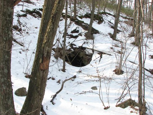
...With nothing but forest for two miles in any direction. The MRDS coordinates were close, but not accurate enough to be helpful. Someone who didn't know what to look for would walk right past this mine entrance and not even know it.
|
|
Therrin
This member has been banned. See the banlist for more information.
location:
North of Chicago, IL
Gender: Male
*Therrin puts on the penguin-suit
| | | Re: mine mapping tools
<Reply # 16 on 9/8/2010 1:43 PM >
| | | | Exactly.
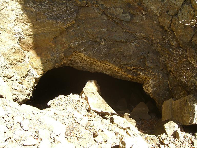
Here's one I recently went to. This shot is taken from about 3 ft away, but from any more than that, all you see is the rockfall in front, you cant even see the opening.
And this was actually a pretty interesting system inside.
Give a person a match and they'll be warm for a minute, but light them on fire and they'll be warm for the rest of their life. =) |
|
Urban-Explorer
location:
Hell's Drain
Gender: Male
| | Re: mine mapping tools
<Reply # 17 on 9/8/2010 2:41 PM >
| | | | Awesome stuff Therrin, thanks for the information.
Main Site: urban-explorer.co.cc
Forum Gallery: ue-gallery.co.cc |
|
Urban-Explorer
location:
Hell's Drain
Gender: Male
| | Re: mine mapping tools
<Reply # 18 on 9/8/2010 3:13 PM >
| | | | Thanks 4 pic clarity. Are those located on surface mines?
Main Site: urban-explorer.co.cc
Forum Gallery: ue-gallery.co.cc |
|
Therrin
This member has been banned. See the banlist for more information.
location:
North of Chicago, IL
Gender: Male
*Therrin puts on the penguin-suit
| | | Re: mine mapping tools
<Reply # 19 on 9/8/2010 4:16 PM >
| | | | "surface"?? well, they're the portal adits from the surface which lead into the mine, yes. (I'm speaking both for mine and his at this point). I could show other examples but it'd just be repetition.
Some are very easy to find, most aren't. Past Producer just means that a lot of time has gone by since it was last worked. Even a lot of the ones marked "active" or "current producer" actually aren't. A lot of the information is old. And the one's that have been bulldozed or blasted shut are even harder to find.
Sometimes you can look on the aerial maps, like Google earth, and select different times of the day to create shadow effects. Look at the earth around the area and see if you can detect patterns of what is natural and what has been disturbed by human, machine, or otherwise.
It's a 50/50 thing though. Some of these difficult-to-find adits (openings) will lead to a sweet exploration, others will lead to an exploratory dig that only goes back 5 or 10 or 20 feet. Some will be filled in. Some that are filled in or gated over can be dug out. We've done that before. The payoff is a total chance though.
We spent 4 hrs digging under a concrete footing to a grate system once. Set a anchor point, rappelled 200ft down the vertical shaft just to find that it led to nowhere. Another one we dug out from a hole the size of a basketball, to something that you had to turn your feet and helmet sideways just to fit to slide down it and drop into the unobstructed adit. That one went back a few hundred feet until the ceiling and floor were so close I was rubbing my back on the roof while sliding along the floor on my belly and finally just gave up as I could see it only got narrower and narrower.
Others you squeeze into and have to crawl and fight and inch your way down a really constricted opening and then it drops into a mine system that's explorable, has multiple levels, interesting things to look at, and all that.
It's a toss up.
Give a person a match and they'll be warm for a minute, but light them on fire and they'll be warm for the rest of their life. =) |
|
Powered by AvBoard AvBoard version 1.5 alpha
Page Generated In: 78 ms
|
|


