 |
|
|
UER Store
|
|
sweet UER decals:

|
|
|
 CMH
 
Gender: Male

 | |  | Using a GPS for UE (Aerial maps)
< on 5/14/2003 2:38 AM >
|  | | | Allright, prompted by a GPS question in another forum, I though I would post a way to use your GPS to get aerial maps of a coordinate you marked on a recon, or maybe found on a website (superfund sites come to mind). Part two is downloading a Terraserver map and putting coordinate grids on it, but I didn't think it would be real useful so I didn't post it. Hope this helps someone with a GPS who wants to use it in UE...
Goal: To use a GPS and satellite maps for UE recon, scouting, and planning.
Supplies: Terraserver (http://terraserver.homeadvisor.msn.com/default.asp), GPS unit (Garmin eTrex used in this tutorial).
Part 1
Goal: Get aerial photographs or Topo maps of a point you marked with your GPS.
1. First you need to get the coordinates from your GPS of the point you marked. Find the name you gave the marked waypoint, and get to the waypoint management screen. For a Garmin eTrex you go to the "Menu" page, then waypoints, then find the point and click it.
2. Your coordinates will look something like this:
32 North, 3.235
97 West, 18.112
or
32 North, 3minutes 14seconds
97 West, 18minutes 6.7seconds
If they are in the second format, you are in luck: this is what the Terraserver uses. If not, it's a simple process to convert them, see the "note on coordinates" down below.
2. Go to http://terraserver.homeadvisor.msn.com/default.asp, "advanced find" (left sidebar as of May 2003), "find geographic place" (left sidebar as of May 2003). Type in your coordinates and go. Zoom the map up and look at the surroundings. Use it to plan entries and exits, or just scope out the surrounding area of your target.
-----------------------------------------------------
A note on coordinates
Your coordinate from a GPS will probably look like this:
32 North, 3.235
97 West, 18.112
For Terraserver use, it should look like this:
32 North, 3minutes 14seconds
97 West, 18minutes 6.7seconds
To get it in minutes/seconds format as used by the Terraserver, either change it in options in your GPS, or change it manually. For map gridding, it's best to leave it in the decimal format so you don't have to do wacky conversions from 100s to 60s. If you are only going to use the GPS to get satellite views of areas, go ahead and change it to min/sec format.
To get the decimals in min/sec format, multiply the decimal by 60 for seconds, and minutes is the whole number before the decimal, SO:
.235 X 60 = 14 seconds
.112 X 60 = 7.7 seconds
32 North, 3minutes 14seconds
97 West, 18minutes 6.7seconds
Keep in mind that the seconds will go from 0-59, so you screwed up if you get something higher than that for seconds.
[last edit 5/13/2003 9:42 PM by CMH - edited 1 times]
"It's funnier that way." |
|
Maverick
Location: South Carolina
| | Re: Using a GPS for UE (Aerial maps)
<Reply # 1 on 7/12/2003 7:25 PM >
| | | | www.books-maps.com I hate giving this source out because I love it so much and some secrets you gotta keep. However this is really really good if your in a big city to see things. Also will help you if your a infil guy who documents things. These images are old mid 80's so take them for what they are. Bad intell as screwed many a battle plans. Also images from top down with shadows make false apperinces such as larger then they are and can hide small buildings in the shadow of a big one and other dangers. If anyone has questions I'll try to answer however I only know a few things a intell guy told me to look for.
egos stop learning and if your not learning your dead |
|
Jester

Location: Vancouver,B.C. Canada
Gender: Male
Always just out of sight...
| |  | Re: Using a GPS for UE (Aerial maps)
<Reply # 2 on 7/12/2003 7:40 PM >
| | | | for around here, I use globeexplorer.com, I've found the satelite photos of every target I've looked up... after you click the map again, it will show up normally. the drawback is that it has the globeexplorer watermark unless you're a paying customer. But oh well, I can live with the watermarks...
It requires wisdom to understand wisdom: the music is nothing if the audience is deaf. |
|
konk
Location: Toronto ON
Gender: Male
| | Re: Using a GPS for UE (Aerial maps)
<Reply # 3 on 7/13/2003 2:09 AM >
| | | | ^ how do you get beyond CITY in detail?
If you ever need any SATs of the island, let me know, I have access to recent ones down to a 1:2000 ratio (I think thats the ratio).
|
|
Jester
Location: Vancouver,B.C. Canada
Gender: Male
Always just out of sight...
| | | Re: Using a GPS for UE (Aerial maps)
<Reply # 4 on 7/13/2003 4:41 AM >
| | | | just picked the area, and zoomed down, never had any problems...
here's a view of the alouette prison we infiltrated, not the highest zoom, because I wanted most of the perimeter in the pic...
It requires wisdom to understand wisdom: the music is nothing if the audience is deaf. |
|
RevSM
Location: South Central Texas

| | | Re: Using a GPS for UE (Aerial maps)
<Reply # 5 on 7/14/2003 3:36 PM >
| | | | You know, with Globe Explorer you can get a picture with only one watermark at the bottom and the one at the top if you take a screenshot (print screen button on your keyboard and paste it into Photoshop and then save it as a jpeg. You have to do some cropping and you still have the watermark but at least it doesn't cover the entire pic.
Tetanus for Breakfast!
http://www.shatteredshutter.com |
|
MacGyver
Location: St Paul, Minnesota
Gender: Male
"Someone go find me a paperclip, a D-cell battery, and a cheese grater"
| | Re: Using a GPS for UE (Aerial maps)
<Reply # 6 on 7/14/2003 4:30 PM >
| | | | I've made large maps using a similar method to this^. copy/paste the image into photoshop, then go back to globeexplorer and move about 2/3 the image to one side. Repeat, overlapping and modifying as desired in photoshop. When your images overlap enough, the area under the watermark is duplicated by another overlapping image without the mark there. Just erase the part with the mark from the first image and let the second one below fill in that part of the image.
Like a fiend with his dope / a drunkard his wine / a man will have lust for the lure of the mine
"If you are not part of the solution, you are not dissolved in the solvent." |
|
Jester
Location: Vancouver,B.C. Canada
Gender: Male
Always just out of sight...
| | | Re: Using a GPS for UE (Aerial maps)
<Reply # 7 on 7/14/2003 4:31 PM >
| | | | good ideas from both of you, thanks.
the watermark hasn't bothered me much, it's nice to have the layout of a place, even with a bit of a watermark, but i'm going to have to try your ideas out...
It requires wisdom to understand wisdom: the music is nothing if the audience is deaf. |
|
Mr. Motts
 
Noble Donor
Location: Long Island and Brooklyn NY
Gender: Male

| | | Re: Using a GPS for UE (Aerial maps)
<Reply # 8 on 7/14/2003 4:47 PM >
| | | | Ahhh awesome reference.. the color photos make a big difference compared to terraserver.
Save the planet... kill yourself.
http://www.opacity.us/ - Abandoned Photography |
|
konk
Location: Toronto ON
Gender: Male
| | Re: Using a GPS for UE (Aerial maps)
<Reply # 9 on 7/14/2003 11:37 PM >
| | | | ^ Yeah, they do. I just wish that I could get zoom in my area.
In some areas it just goes black (with the watermark), and some areas the zoom buttons are greyed out and say "not available" or something like that when you put the mouse overtop.
|
|
RevSM
Location: South Central Texas
| | | Re: Using a GPS for UE (Aerial maps)
<Reply # 10 on 7/15/2003 3:14 PM >
| | | | Yeah, that seems to be the only problem that I find. They only seem to have aerial maps of areas that are densely populated like major cities.
Tetanus for Breakfast!
http://www.shatteredshutter.com |
|
Jester
Location: Vancouver,B.C. Canada
Gender: Male
Always just out of sight...
| | | Re: Using a GPS for UE (Aerial maps)
<Reply # 11 on 7/15/2003 3:22 PM >
| | | | I've found it do that to me in some areas, but then when I fiddle back and forth with clicking on the pic in the top left and then the main zoomed pic, it ends up working...
It requires wisdom to understand wisdom: the music is nothing if the audience is deaf. |
|
Mr. Motts
Noble Donor
Location: Long Island and Brooklyn NY
Gender: Male
| | | Re: Using a GPS for UE (Aerial maps)
<Reply # 12 on 7/15/2003 4:40 PM >
| | | | This might be obvious but I will point it out... I composited 2 maps of the same area, with terraserver and globexplorer... even though globex gets in much closer, many old streets that have grown over are very tough to see, and footpaths and streams are indistinguishable, whereas terraserver is much easier to see. It's becuase terraserver's maps are older ('94 compared to '01) so things aren't too overgrown and the terraserver map was taken in March when leaves were sparse compared to July.
Here's a snip.. in globex you can see the road gets lost, and the only indication of a stream to the right is a slightly darker treeline. But the detail on the buildings and open areas is amazing!

So check both resources, and any other satellite photos if there are any.
And those prices on globexplorer are outrageous.
Save the planet... kill yourself.
http://www.opacity.us/ - Abandoned Photography |
|
RevSM
Location: South Central Texas
| | | Re: Using a GPS for UE (Aerial maps)
<Reply # 13 on 7/15/2003 5:35 PM >
| | | | I agree, use both. I see your point in that you can see the paths better but I sometimes check a place out on Globe Explorer before I ever even see it in person. Sometimes I will be doing research online looking for spots and when I find a place that may or may not even exist anymore I can see a more recent aerial and find out right away if it's still there or if its a bare patch of land where a building used to be.
Tetanus for Breakfast!
http://www.shatteredshutter.com |
|
Ferret

Location: Toronto
| | Re: Using a GPS for UE (Aerial maps)
<Reply # 14 on 7/15/2003 8:57 PM >
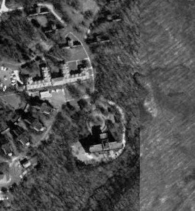
| | | | As well, if you have something like Photoshop on your machine, you can combine many images to create on larger map.
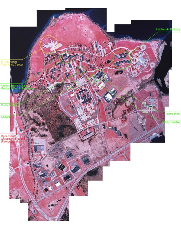
This image has been greatly shrunk to avoid eating up Av's server space. The actual resolution is like this:

These are part of the intelligence for a large scale exploration of an abandonned asylum in Upstate NY. We're planning an expedition out there later this summer.
|
|
RevSM
Location: South Central Texas
| | | Re: Using a GPS for UE (Aerial maps)
<Reply # 15 on 7/15/2003 9:33 PM >
| | | | *drooool* Very nice. Haven't tried to get that detailed yet.
Tetanus for Breakfast!
http://www.shatteredshutter.com |
|
konk
Location: Toronto ON
Gender: Male
| | Re: Using a GPS for UE (Aerial maps)
<Reply # 16 on 7/16/2003 2:01 AM >
| | | | Found the problem. The pics taken for my area on globeexplorer are from 1991. Way too outdated for me, and probably didn't need the resolution back then that they use now.
I have access to pretty high detail black & whites though.
|
|
Freak

Location: Usually Alaska, now MSP.
Gender: Male

Hypocrite
| | | Re: Using a GPS for UE (Aerial maps)
<Reply # 17 on 7/17/2003 7:28 PM >
| | | | I recently found a source for marine charts and coastal aerial photos; www.marineplanner.com In some cases you can zoom much closer than with topozone or other topographic maps, but the amount of detail will be less (and focused on landmarks that are related to boats)
Turn off the internet and go play outside.
http://spamusement...hp/comics/view/137 |
|
|
|
All content and images copyright © 2002-2024 UER.CA and respective creators. Graphical Design by Crossfire.
To contact webmaster, or click to email with problems or other questions about this site:
UER CONTACT
View Terms of Service |
View Privacy Policy |
Server colocation provided by Beanfield
This page was generated for you in 140 milliseconds. Since June 23, 2002, a total of 739808026 pages have been generated.
|
|

