forums
new posts
donate
UER Store
events
location db
db map
search
members
faq
terms of service
privacy policy
register
login


Location DB > Canada > Ontario > Cornwall > Cornwall Canal > Cornwall Canal > 20

20 / 20   20

Description
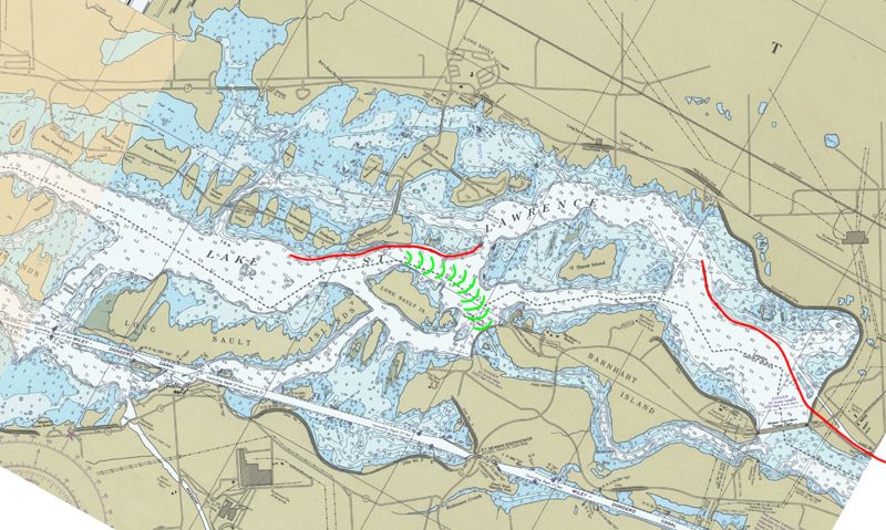
The same area following the inundation of 1958. Flip back and forth between this map and the previous one to see the changes that took place in this area.

Most of the Cornwall Canal is now under the waters of Lake St. Lawrence. Residents of the towns and villages along the Canadian shore of the river were relocated to the new towns of Long Sault (top center) and Ingleside (top left). Miles of Highway #2 and the main CNR train line were relocated north.

Between 1954 and 1959, Canadian and American engineers built the Moses-Saunders Power Dam (at bottom right), the Long Sault Spillway Dam (where the rapids were) and a crap load of dikes to keep the flooding to a minimum.

On the American side of the border, the Wiley-Dondero Ship Canal was dug through farmland and dredged out of the river bottom, and two locks of the St. Lawrence Seaway System were installed to lift the big ships past the power dam. Major changes, indeed.
Controls

Return to Main Location Page

Return to Gallery Overview

Edit this Gallery

Edit this Picture

Subscribe this Picture
Comments
Posted by 'Dukes 12/4/2005 1:14 PM | remove
  Thanks for the gallery; sometimes the stuff right in front of your face is a mystery you didn't know existed. I'm only familiar with the American side (went to school in Potsdam).

Posted by Emperor Wang 12/9/2005 1:41 AM | remove
  Glad you enjoyed it. If you want to learn more, here's a history of the project from the US Army Corps of Engineers' perspective...

http://www.usace.army.mil/inet/usace-docs/eng-pamphlets/ep870-1-20/

Not a bad read. If you're into that sort of thing.
Posted by airmyles13 12/14/2007 7:00 AM | remove
  Thanks for the gallery... it's interesting to find out about history like this!
Posted by BravoOrig 3/5/2008 1:11 PM | remove
  Thanks for the link Emperor Wang, I'll have to look up one of their projects where they redirected the MO river near my hometown.
Posted by housedreamer 11/21/2012 4:13 PM | remove
  Really enjoyed the info and great camera work.
Posted by Emperor Wang 12/25/2012 1:40 AM | remove
  Thanks! I'm a total nerd for Seaway stuff. I guess it shows, eh.
Posted by nostra-YOUPPI! 12/29/2012 10:14 PM | remove
  I will have to dig out my books on the seaway and scan them in here.
Posted by Emperor Wang 1/1/2013 3:43 PM | remove
  Where have I heard that before?

:-P
Posted by nostra-YOUPPI! 1/2/2013 1:59 AM | remove
  i know wang, i know, you would love the book
If you'd like to add a comment, please login or register.


All content and images copyright © 2002-2024 UER.CA and respective creators. Graphical Design by Crossfire.
To contact webmaster, or click to email with problems or other questions about this site: UER CONTACT
View Terms of Service | View Privacy Policy | Server colocation provided by Beanfield
This page was generated for you in 267 milliseconds. Since June 23, 2002, a total of 739776971 pages have been generated.