|
|
|
UER Store
|
|
sweet UER decals:

|
|
|
|
Activity
|
|
488 online
Server Time:
2024-04-20 14:08:21
|
|
|
 |
|
|
|
|
Location DB >
Mariana Island >
Commonwealth of the Northern M >
Tinian >
American Ruins
|
|
Log in to activate viewing options
|
|
|
 |
Publically Viewable |
|
This location has been labeled by its creator as Public, and therefore can be viewed by anyone.
|
|
|
|
|
|
Part of the Mariana Islands and the Commonwealth of the Northern Mariana Islands (CNMI) in the Central Pacific, Tinian is three miles south of Saipan and only slightly smaller (about 70 square miles). It is mostly flat with its highest point reaching only 500 feet. There are a couple hotels including a small casino (mostly Chinese customers). The island is completely open for anyone to travel nearly anywhere. The only restricted areas are fenced-in old munitions dumps.
|
|
|
Type: Outdoors
Status:
Accessibility:
Recommendation: check it out if you're nearby
|
|
|
Address
Tinian, Commonwealth of the Northern M
Mariana Island
Owner: CNMI-Under permanent lease by the U.S. Military
See a map of this location
|
|
|
|
|
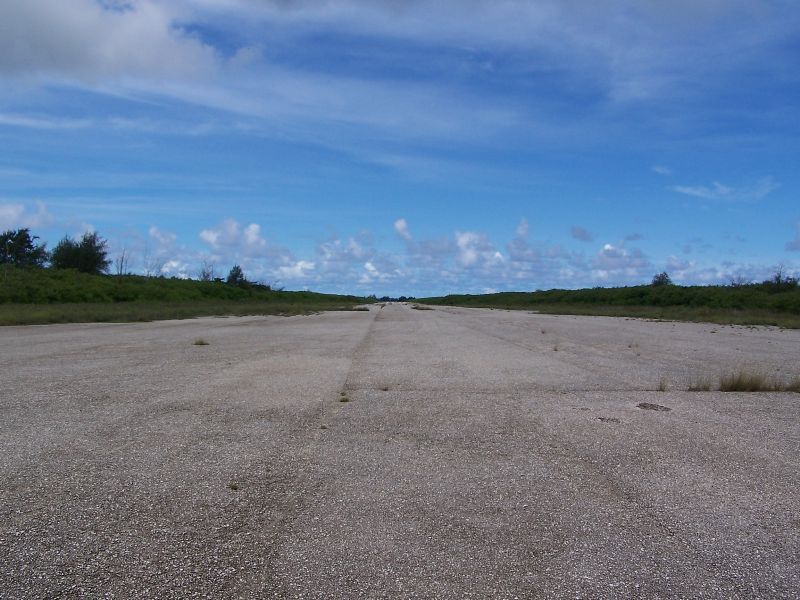
There are many notable features on Tinian left from use as an American airbase. The most obvious features are the extensive road network and four massive concrete runways and countless taxiways. Of particular interest are the two bomb pits specifically designed and built to lift the 9,000lb atomic bombs into the B-29s. There are also many vehicles such as landing craft and a few buildings.
|
|
|
|
|
|
|
|
|
After Tinian was captured by American in August, 1944, Tinian was converted by the Americans into the largest air base in the world. The work was done entirely by the Navy Seabees. The northern half of Tinian was covered by four gigantic runways (Able, Baker, Charlie, and Dog) to support the new B-29 bombers in the strategic bombing of Japan. Nearly 1,000 B-29s were based on Tinian alone in addition to nearly 50,000 American pilots, bomber crews, support staff, and troops. Throughout 1945, B-29s based in the Marianas decimated Japan in relentless firebombing on an almost daily basis. On August 6 and 9, 1945, B-29s from Tinian dropped Atomic Bombs on Hiroshima and Nagasaki. After Japan's surrender, the Tinian airbase was closed in 1947 and the Chamorro people were allowed to return. Today, Tinian, along with Saipan and Rota, is part of the U.S. affiliated Commonwealth of the Northern Mariana Islands or CNMI. The U.S. navy maintains a permanent lease on most of Tinian including the former North Field complex.
|
|
|
|
|
The U.S. Navy holds a permanent lease on most of Tinian. Over the past thirty years, the military has used the land for training on a few occasions. By 2010, the U.S. military will begin to transfer 10,000-12,000 Marines to the Marianas. Since the Navy lease on Tinian is the largest undeveloped or used land, the Marines will most likely use the land for training purposes.
|
|
|
|
|
|
|
|
|
|
The moderator rating is a neutral rating of the content quality, photography, and coolness of this location.
This location has not yet been rated by a moderator.
|
|
 This location's validation is current. It was last validated by
Opheliaism on 8/9/2010 8:43 AM.
This location's validation is current. It was last validated by
Opheliaism on 8/9/2010 8:43 AM.
|
|
|
on Aug 9 10 at 8:43, Opheliaism validated this location
on Aug 9 10 at 8:43, Opheliaism validated this location
on Aug 9 10 at 6:02, blueblocker changed the following: Province / State (please use full name), Country
on Oct 7 08 at 19:38, Opheliaism validated this location
on Oct 4 08 at 3:47, JC changed the following: Country
on Sep 15 08 at 6:17, SaraBellum validated this location
on Sep 14 08 at 15:57, Steed validated this location
on Sep 14 08 at 4:50, blueblocker updated gallery picture North Field in 1995
on Sep 14 08 at 4:49, blueblocker updated gallery picture NPS area study map
on Sep 14 08 at 4:46, blueblocker updated gallery picture LVT remains on beach
|
|
|
|
|
|
|
Is this location inappropriate / broken / missing key info?
If it's something you can fix, please scroll up and click the EDIT button.
If this location was only posted a few days ago, give the creator time to work on it.
Please try sending a message directly to the creator of the location. You'll find that info at the top of this page.
Otherwise, ONLY if you've already tried to contact the original creator,: Click here to notify an administrator.
|
|
|
|
All content and images copyright © 2002-2024 UER.CA and respective creators. Graphical Design by Crossfire.
To contact webmaster, or click to email with problems or other questions about this site:
UER CONTACT
View Terms of Service |
View Privacy Policy |
Server colocation provided by Beanfield
This page was generated for you in 93 milliseconds. Since June 23, 2002, a total of 738602530 pages have been generated.
|
|