|
|
|
UER Store
|
|
sweet UER decals:

|
|
|
 |
|
|
|
|
Location DB >
Mariana Island >
Commonwealth of the Northern M >
Tinian >
Japanese Ruins
|
|
Log in to activate viewing options
|
|
|
 |
Publically Viewable |
|
This location has been labeled by its creator as Public, and therefore can be viewed by anyone.
|
|
|
|
|
|
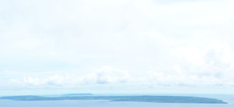
Part of the Mariana Islands and the Commonwealth of the Northern Mariana Islands (CNMI) in the Central Pacific, Tinian is three miles south of Saipan and only slightly smaller (about 70 square miles). It is mostly flat with its highest point reaching only 500 feet. There are a couple hotels including a small casino (mostly Chinese customers). The island is completely open for anyone to travel nearly anywhere. The only restricted areas are fenced-in old munitions dumps.
|
|
|
Type: Outdoors
Status: Abandoned
Accessibility: Easy
Recommendation: worth the trip
|
|
|
Address
Tinian, Commonwealth of the Northern M
Mariana Island
Owner: Various owners, U.S. Government, and the Commonwealth of the Northern Mariana Islands
See a map of this location
|
|
|
asbestos
rust
unsafe flooring
flooding
water
|
|
|
There are many buildings, bunkers, and structures, mostly Japanese, as well as four huge tarmacs, countless taxi-ways and large road network built to support the gigantic air base. Most of the American buildings were temporary structures such as quonset huts and are gone. Several of the Japanese structures, however, are bomb proof and still remain. There are also many abandoned vehicles and wreckage, mostly American.
|
|
|
|
|
|
|
|
|
Tinian was first claimed by Spain in the late 1600s and after nearly 300 years as a neglected Spanish colony, it was purchased along with the other Mariana Islands (except Guam) by Germany in 1899. In 1914, Japan went to war with the Allies against Germany and after only 15 years as a German colony, Tinian became Japanese. Japan converted Tinian into the most produtive sugar cane producer in the Empire. All the native Chamorro people were removed and taken to Saipan. On July 24, 1944 Tinian was invaded by American forces as part of Operation Forager, the campaign to capture the Mariana Islands. After what was later described as the most successful amphibious operation of the war, Tinian was converted by the Americans into the largest air base in the world. The northern half of Tinian was covered by four gigantic runways to support the new B-29 bombers in the strategic bombing of Japan. Throughout 1945, B-29s based in the Marianas decimated Japan in relentless firebombing on an almost daily basis. On August 6 and 9, 1945, B-29s from Tinian dropped Atomic Bombs on Hiroshima and Nagasaki. After Japan's surrender, the Tinian airbase was closed in 1947 and the Chamorro people were allowed to return. Today, Tinian, along with Saipan and Rota, is part of the U.S. affiliated Commonwealth of the Northern Mariana Islands or CNMI.
|
|
|
|
|
Currently, there is a plan to relocate a large contingent of Marines (10-12 thousand) from Okinawa to Guam. Tinian will most likely become a training center for artillery and rifle practice. Travel to Tinian will most likely be more difficult or even restricted.
|
|
|
|
|
|
|
|
|
|
The moderator rating is a neutral rating of the content quality, photography, and coolness of this location.
This location has not yet been rated by a moderator.
|
|
 This location's validation is current. It was last validated by
Opheliaism on 8/9/2010 8:47 AM.
This location's validation is current. It was last validated by
Opheliaism on 8/9/2010 8:47 AM.
|
|
|
on Aug 9 10 at 8:47, Opheliaism validated this location
on Aug 9 10 at 6:05, blueblocker changed the following: Province / State (please use full name), Country
on Oct 6 08 at 2:46, Steed validated this location
on Oct 4 08 at 3:50, JC changed the following: Country
on Aug 28 08 at 2:59, Steed validated this location
on Aug 27 08 at 13:15, blueblocker changed the following: Province / State (please use full name)
on Aug 27 08 at 9:28, blueblocker changed the following: Province / State (please use full name)
on Aug 27 08 at 9:26, blueblocker changed the following: Display Name, Province / State (please use full name)
on Aug 26 08 at 14:31, blueblocker changed the following: Description
on Aug 26 08 at 14:14, blueblocker swapped pictures 17 and 18
|
|
|
|
|
|
|
Is this location inappropriate / broken / missing key info?
If it's something you can fix, please scroll up and click the EDIT button.
If this location was only posted a few days ago, give the creator time to work on it.
Please try sending a message directly to the creator of the location. You'll find that info at the top of this page.
Otherwise, ONLY if you've already tried to contact the original creator,: Click here to notify an administrator.
|
|
|
|
All content and images copyright © 2002-2024 UER.CA and respective creators. Graphical Design by Crossfire.
To contact webmaster, or click to email with problems or other questions about this site:
UER CONTACT
View Terms of Service |
View Privacy Policy |
Server colocation provided by Beanfield
This page was generated for you in 141 milliseconds. Since June 23, 2002, a total of 739329094 pages have been generated.
|
|