|
|
|
UER Store
|
|
sweet UER decals:

|
|
|
 |
|
|
|
|
Location DB >
United States >
California >
Monterey >
East Garrison
|
|
Log in to activate viewing options
|
|
|
 |
Publically Viewable |
|
This location has been labeled as Demolished, and therefore can be viewed by anyone.
|
|
|
|
|
|
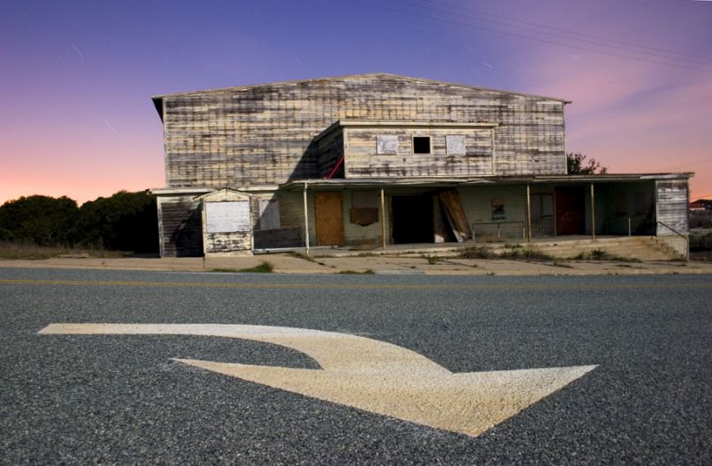
The East Garrison occupies 350 acres on the northeasternedge of the Fort Ord base and consists of military and industrial support areas, recreational facilities,and recreational open space
|
|
|
Type: Building
Status: Demolished
Accessibility: Difficult
Recommendation: worth the trip
|
|
|
|
asbestos
rust
unsafe flooring
air quality
|
|
|
|
fences
barbed wire
part-time guard
locked gates
|
|
|
|
flashlight
gloves
long pants / sleeves
towelettes
|
|
|
|
But Fort Ord's true origin of development dates back to the year 1917. In August of that year the US government purchased 15,000 acres next to the area known today as the East Garrison, for the amount of 160,000 dollars. At that time the property was known as the Gigling Military Reservation. The name Gigling originated from a German family that had once held title to the property in that general area. So the fort's official title became Camp Gigling. Between the end of World War I and pre-World War II. Camp Gigling was primarily used as a maneuver area for the 11th "Black Horse" Cavalry and a artillery target range for the 76th Field Artillery. Both units were stationed at the Presidio of Monterey. During the summertime the 30th Infantry Regiment came down from the Presidio of San Francisco to use the reservation for maneuvers as did other Reserve and National Guard units.
By 1933 when the reservation's name was changed to Camp Ord. It's landscaping was brush covered and almost impenetrable in many places. A simple dirt and gravel road connected the East Garrison and Gigling railroad spur located on Highway #1. There was a water well, a caretaker's house in the center of the reservation and a few bivouac sites. But other than these limited improvements. No additional changes were made at Camp Ord until 1938.
The major changes of 1938 marked the excelled growth of the post. Colonel Homer M. Groninger, who was promoted to Major General at a later date, was in charge of the work and renovation. Utilizing the benefits of President Franklin D.Roosevelt's/ Works Projects Administration program. Col. Groninger supervised the expansion of the post into a large camp about a mile from the Gigling railroad spur and saw to it that the dense brush areas were cleared for future construction. Col. Groninger was working with an original WPA appropriation of $800,000. That amount would grow to over $6,000,000 for additional construction at the post.
On Jan 4th 1940 the first joint Army and Navy maneuvers were held at the fort. A total of 10,000 troops and 1000 vehicles, boats, and horses took part in the maneuvers. Later in 1940 Col. Groninger gave instructions to build the first wooden barracks and mess halls. He included the tent city slabs in the East Garrison. The wooden barracks were suppose to be temporary. Not to last much longer than 5 years. The construction was so well done.They are still there today.
|
|
|
|
|
http://www.eastgarrison.com/
The Draft Specific Plan envisions 1,400 housing units, 75,000 square feet (sf) of commercial, 11,000 sf of institutional uses, and 100,000 sf of artist studio space to be built in three phases over the next 20 years.
Based on "smart growth" development principles, this new community will include affordable housing, walkable streets, a town center, and a cultural arts district.
|
|
|
|
|
|
|
|
|
|
The moderator rating is a neutral rating of the content quality, photography, and coolness of this location.
This location has not yet been rated by a moderator.
|
|
 This location's validation is current. It was last validated by
Emperor Wang on 2/9/2008 4:00 AM.
This location's validation is current. It was last validated by
Emperor Wang on 2/9/2008 4:00 AM.
|
|
|
on Feb 9 08 at 4:00, Emperor Wang validated this location
on Feb 9 08 at 3:37, cambrianguy changed the following: Status
on Feb 12 07 at 15:58, Emperor Wang validated this location
on Feb 11 07 at 20:45, tunnelbug made this location available
on Feb 11 07 at 20:45, tunnelbug changed the following: Notes for Mods, Owner, Type, City, Province / State (please use full name), Country, Latitude, Longitude, Prefer Satellite, Publically Viewable, History, Year Built, Year Closed, Status, Accessibility, Hazards, Interesting Features,
on Feb 11 07 at 20:32, tunnelbug updated gallery picture Barracks
on Feb 11 07 at 20:32, tunnelbug updated gallery picture Demo Shed
on Feb 11 07 at 20:32, tunnelbug updated gallery picture Mess Hall
on Feb 11 07 at 20:32, tunnelbug updated gallery picture Pampas near Warehouses
on Feb 11 07 at 20:32, tunnelbug updated gallery picture Church on the Hill
|
|
|
|
|
|
|
Is this location inappropriate / broken / missing key info?
If it's something you can fix, please scroll up and click the EDIT button.
If this location was only posted a few days ago, give the creator time to work on it.
Please try sending a message directly to the creator of the location. You'll find that info at the top of this page.
Otherwise, ONLY if you've already tried to contact the original creator,: Click here to notify an administrator.
|
|
|
|
All content and images copyright © 2002-2024 UER.CA and respective creators. Graphical Design by Crossfire.
To contact webmaster, or click to email with problems or other questions about this site:
UER CONTACT
View Terms of Service |
View Privacy Policy |
Server colocation provided by Beanfield
This page was generated for you in 171 milliseconds. Since June 23, 2002, a total of 739257549 pages have been generated.
|
|