|
|
|
|
|
Location DB >
United States >
Missouri >
St. Louis >
Mole Tunnel and Abandoned Right of Way
|
|
Mole Tunnel and Abandoned Right of Way
|
|
|
Log in to activate viewing options
|
|
|
created by oh-ten
on 1/15/2007 9:26 PM
last modified by oh-ten
on 2/3/2013 11:37 PM
|
|
 |
Publically Viewable |
|
This location has been labeled as Demolished, and therefore can be viewed by anyone.
|
|
|
|
|
|
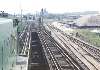
Roughly 40' wide by 20' high former electric railway tunnel dug under a street with dirt and gravel banks and numerous homeless inhabitants.
The tunnel connects to an elevated right of way on one end and to a sealed former station on the other.
|
|
|
Type: Tunnel
Status: Demolished
Accessibility: Easy
Recommendation: check it out if you're nearby
|
|
|
|
rust
unsafe flooring
Mole People
|
|
|
-Huge tunnel under downtown St. Louis exposing the basement levels of office buildings
-Interesting views up to the street level
-Dug in encampments of "mole people" hidden in the side banks of the structure with cooking fires and in some cases partial living rooms (but please respect their homes!)
-Original electric railway equipment and signage
|
|
|
|
|
|
flashlight
gloves
long pants / sleeves
towelettes
|
|
|
|
The tunnel and right of way was originally the trackage for the Illinois Terminal Railway which ran electric interurban service from St. Louis throughout south-central Illinois. A large (40'?) wide tunnel was dug under a major city street using the cut-and-cover method. The tunnel begins deep under a former newspaper building which had the (reportedly) lavish station located down a long flight of stairs. At this point this area seems to be sealed off with a double layer of drywall and the tunnel begins to constrict until finally ending in a dirt bank. Heading away from the former station the building passes two semi-active loading docks and continues for several blocks before emerging onto grade and then on to a series of viaducts eventually crossing over railyards and connecting with the McKinley bridge.
Service on the line was terminated in 1954, but the tunnel was used for sporadic freight services until the past decade.
|
|
|
|
|
As of 2012, Tucker Bvld.has been rebuilt, the Tucker viaduct and tunnel have been demolished and sealed with foam and concrete.
A portion of the viaduct near the McKinley Bridge is still planned to become an elevated bike trail and park called the Iron Horse Trestle.
|
|
|
|
|
|
|
|
|
|
The moderator rating is a neutral rating of the content quality, photography, and coolness of this location.
This location has not yet been rated by a moderator.
|
|
 This location's validation is current. It was last validated by
Opheliaism on 2/4/2013 1:58 PM.
This location's validation is current. It was last validated by
Opheliaism on 2/4/2013 1:58 PM.
|
|
|
on Feb 4 13 at 13:58, Opheliaism validated this location
on Feb 3 13 at 23:37, oh-ten changed the following: Owner, Latitude, Longitude, Co-ordinate Accuracy, Publically Viewable, Year Closed, Status, Future Plans
on Nov 26 08 at 3:36, Emperor Wang validated this location
on Nov 26 08 at 2:55, oh-ten changed the following: Latitude, Longitude, Co-ordinate Accuracy
on Nov 23 08 at 15:50, Emperor Wang validated this location
on Nov 23 08 at 2:08, Jamesw changed the following: Latitude, Longitude, Co-ordinate Accuracy
on Jan 15 07 at 23:46, Emperor Wang validated this location
on Jan 15 07 at 23:28, oh-ten updated gallery picture Sign
on Jan 15 07 at 23:27, oh-ten swapped pictures 8 and 9
on Jan 15 07 at 23:27, oh-ten swapped pictures 7 and 9
|
|
|
|
|
|
|
Is this location inappropriate / broken / missing key info?
If it's something you can fix, please scroll up and click the EDIT button.
If this location was only posted a few days ago, give the creator time to work on it.
Please try sending a message directly to the creator of the location. You'll find that info at the top of this page.
Otherwise, ONLY if you've already tried to contact the original creator,: Click here to notify an administrator.
|
|
|

 order your copy of Access All Areas today!