|
|
|
UER Store
|
|
sweet UER decals:

|
|
|
 |
|
|
|
|
Location DB >
United States >
California >
Death Valley >
Harrisburg Mining Area
|
|
Log in to activate viewing options
|
|
|
created by rapcw
on 4/13/2006 11:14 AM
last modified by rapcw
on 12/27/2006 3:02 AM
|
|
 |
Publically Viewable |
|
This location has been labeled by its creator as Public, and therefore can be viewed by anyone.
|
|
|
|
|
|
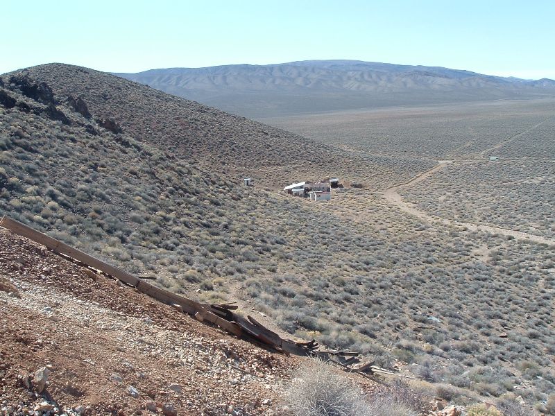
The remains of Harrisburg and Aguereberry Camp, a mill, and various mining enterprises.
|
|
|
Type: Outdoors
Status: Abandoned
Accessibility: Easy
Recommendation: check it out if you're nearby
|
|
|
|
rust
unsafe flooring
Mine hazards
|
|
|
Aguereberry Camp, the Eureka mine and various other mines around, the Cashier Mill.
|
|
|
Many shafts and tunnels sealed.
|
|
|
|
|
|
|
Famous Death Valley prospector Frank "Shorty" Harris and a young greenhorn named Jean Pierre Aguereberry, also known as Pete, were on the way to Ballarat after a Fourth of July party at Rhyolite in 1905. On the way, Aguereberry discovered a pocket of gold ore at a presumed "barren" rock cropping, and after some convincing by Pete, Harris believed it could be a great producer. Pete claimed the north half, which he named the Eureka, and Harris the south, which he called Providence. Continuing on to Ballarat, Shorty mentioned the find to everyone he encountered, calling it the "biggest strike ever made in the Southwest", and in many recountings of the tale, the fact that Pete found it was conveniently left out. Word of the strike with assays going over $500 a ton quickly spread, and within ten days 300 men were on the ground; within two months there were more than 500. A new town was christened Harrisbury, after the two discoverers, but the y would soon be changed to a g, making it Shorty's town alone.
Shorty headed off to San Francisco with the help of some partners, and quickly found backers to form the Cashier Gold Mining Company in September, and promply sent a couple dozen miners to work to open the Cashier. Aguereberry also recieved backers in Los Angeles and formed the Midas Panamint Mining Company in January 1906. But by then the excitement surrounding the place had died down, thanks to a large new strike just over the hill in Skidoo. The planned merger of the two companies in 1907 fell through because of litigation involving Pete's company. Shorty's partners in San Francisco gave up their interest in the mine to a former Montana rancher, Thomas E. Crawford, who thought it was some sort of wonder mine. Shorty lost his stock in the company, leaving Crawford as the sole major stockholder. But working the mine was tough and cost much money and time before the mine could even begin to pay.
In the Spring of 1909 Crawford finally hit enough good ore to warrant putting up a three-stamp mill with a 25-horsepower engine. He set the mill up in July, and by August he had his first gold brick. Meanwhile Pete had found some good paying ore, but no money to develop it, so Crawford and Aguereberry entered into a partnership. Together they started turning out as much as $10,000 dollars a month in bullion, payed off their debts, and began to make a profit. However the partnership soured when Pete began making passes at Crawford's wife, and the two got into an old West shootout, with Pete being grazed by a bullet on the scalp. The judge threw out the case, and after they left the courtroom, they got at it again, with Pete getting pretty well roughed up. Crawford sold out that winter and left for Los Angeles, with his wife. Pete continued to work the mines on and off all the way until his death in 1945. After that the whole place was again barren, this time of gold and souls.
|
|
|
|
|
|
|
|
|
|
|
|
|
The moderator rating is a neutral rating of the content quality, photography, and coolness of this location.
This location has not yet been rated by a moderator.
|
|
 This location's validation is current. It was last validated by
Emperor Wang on 12/27/2006 3:51 AM.
This location's validation is current. It was last validated by
Emperor Wang on 12/27/2006 3:51 AM.
|
|
|
on Dec 27 06 at 3:51, Emperor Wang validated this location
on Dec 27 06 at 3:02, rapcw changed the following: Latitude, Longitude, Co-ordinate Accuracy
on Dec 27 06 at 2:47, rapcw changed the following: Latitude, Longitude, Co-ordinate Accuracy
on Apr 23 06 at 18:55, Emperor Wang validated this location
on Apr 14 06 at 0:03, rapcw made this location available
on Apr 13 06 at 14:09, rapcw updated gallery "Biggest strike in the Southwest"
on Apr 13 06 at 14:08, rapcw updated gallery picture death valley 113.jpg
on Apr 13 06 at 14:07, rapcw updated gallery picture death valley 113.jpg
on Apr 13 06 at 14:07, rapcw updated gallery picture death valley 112.jpg
on Apr 13 06 at 14:06, rapcw updated gallery picture death valley 107.jpg
|
|
|
|
|
|
|
Is this location inappropriate / broken / missing key info?
If it's something you can fix, please scroll up and click the EDIT button.
If this location was only posted a few days ago, give the creator time to work on it.
Please try sending a message directly to the creator of the location. You'll find that info at the top of this page.
Otherwise, ONLY if you've already tried to contact the original creator,: Click here to notify an administrator.
|
|
|
|
All content and images copyright © 2002-2024 UER.CA and respective creators. Graphical Design by Crossfire.
To contact webmaster, or click to email with problems or other questions about this site:
UER CONTACT
View Terms of Service |
View Privacy Policy |
Server colocation provided by Beanfield
This page was generated for you in 109 milliseconds. Since June 23, 2002, a total of 739316932 pages have been generated.
|
|