|
|
|
|
|
Location DB >
United States >
Colorado >
Colorado Springs >
The Churnel
|
|
Log in to activate viewing options
|
|
|
created by Twystr
on 2/28/2006 8:10 AM
last modified by Emperor Wang
on 12/22/2023 5:42 AM
|
|
 |
Publically Viewable |
|
This location has been labeled by its creator as Public, and therefore can be viewed by anyone.
|
|
|
|
|
|
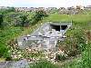
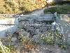
Big, dark, very dangerous to inexperienced drainers. Typical suburban drain with a shrinking outfall / infall. Infall is about a 8x6 box, then downstream at the actual outfall, it is about 12x10 feet with an impressive churn block setup before going into Cottonwood Creek.
|
|
|
Type: Drain
Status: Draining away and eating people when it rains
Accessibility: Easy
Recommendation: check it out if you're nearby
|
|
|
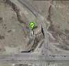
Address
Woodmen Rd and Austin Bluffs Blvd
Colorado Springs, Colorado
United States
Owner: City Of Colorado Springs, Streets Division
See a map of this location
|
|
|
flooding
water
two kids died here in a storm on June 21st 2005
|
|
|
Huge outfall structure with a cable spool lodged in the right tunnel. The churn blocks continue into tunnel itself. About an eight by ten foot concrete box tunnel (RCT) or (CBT) type structure. Not a great place to be when it rains. Two teenaged kids died here in 2005 during a thunderstorm as they were in the upper portion of the tunnel. They were washed through the system and got ate up in the blocks at its outfall.
|
|
|
fences
rocky, treacherous terrain near outfall, visible from both Woodmen and Austin Bluffs, police patrol area frequently from ground and air
|
|
|
|
flashlight
rope
gloves
head protection
long pants / sleeves
ubers!
|
|
|
|
Built along with the area in the eighties, Ii follows Austin Bluffs and doesn’t go under anything, not even the street. It is adjacent to a natural creek bed, looks to divert the creek to prevent more erosion. It drains into Cottonwood Creek, part of the Fountain Creek Watershed.
|
|
|
|
|
Extensions and additions to system as area develops more are a definite possibility...
|
|
|
|
|
|
|
|
|
|
The moderator rating is a neutral rating of the content quality, photography, and coolness of this location.
This location has not yet been rated by a moderator.
|
|
 This location's validation is current. It was last validated by
Emperor Wang on 12/22/2023 5:43 AM.
This location's validation is current. It was last validated by
Emperor Wang on 12/22/2023 5:43 AM.
|
|
|
on Dec 22 23 at 5:43, Emperor Wang validated this location
on Dec 22 23 at 5:42, Emperor Wang changed the following: History, Hazards, Interesting Features, Security Measures, Media Coverage, Future Plans, Description, Web Links
on Oct 27 06 at 13:53, nostra-YOUPPI! validated this location
on Sep 14 06 at 1:21, Twystr updated gallery picture water.jpg
on Sep 14 06 at 1:20, Twystr made this location public
on Sep 14 06 at 1:20, Twystr changed the following: History, Hazards, Interesting Features, Required Equipment, Recommended Equipment, Description
on Sep 14 06 at 1:18, Twystr updated the main picture
on Sep 14 06 at 1:17, Twystr updated gallery picture Inwards.jpg
on Sep 14 06 at 1:17, Twystr updated gallery picture Shadow.jpg
on Sep 14 06 at 1:16, Twystr updated gallery picture memories2.jpg
|
|
|
|
|
|
|
Is this location inappropriate / broken / missing key info?
If it's something you can fix, please scroll up and click the EDIT button.
If this location was only posted a few days ago, give the creator time to work on it.
Please try sending a message directly to the creator of the location. You'll find that info at the top of this page.
Otherwise, ONLY if you've already tried to contact the original creator,: Click here to notify an administrator.
|
|
|

 order your copy of Access All Areas today!