|
|
|
UER Store
|
|
sweet UER decals:

|
|
|
|
Activity
|
|
919 online
Server Time:
2024-04-24 23:03:26
|
|
|
 |
|
|
|
|
Location DB >
Mexico >
Veracruz >
Papantla >
El Tajin
|
|
Log in to activate viewing options
|
|
|
created by lopix
on 7/27/2005 12:52 PM
last modified by lopix
on 7/30/2005 4:17 PM
|
|
 |
Publically Viewable |
|
This location has been labeled by its creator as Public, and therefore can be viewed by anyone.
|
|
|
|
|
|
El Tajin is located 130 miles northeast of Mexico City and is easily reached from there, Veracruz, or Tampico. El Tajin has been described as the second largest archeological site in Mexico. By 1997 they had identified almost 200 structures.
Emerging at the end of the seventh century A.D., El Tajin dominated the northern Atlantic Gulf Coast region throughout both the Classic and Epi-Classic periods and eventually became a source of stylistic influence for Chichen Itza, Cholula, and Cacaxtla. The site was ultimately abandoned by A.D. 1150, but the ruins continue to be revered by the local Totonac people, who may have displaced the original Huaxtec residents around that time.
The layout of the site is determined by the land form. El Tajin is in a valley enclosed on 3 1/2 sides. The north side of the site crosssection has been terraced into 2 levels above the main level (main level is assumed to be the level of the Pyramid of the Niches). The terracing of the levels probably supplied the fill for the structures.
The lowest is assumed to be the earliest. The middle level is called Tajin Chico (little Tajin) and the highest level is identified by "columns" in the name because of the dominant structure - the Building of the Columns. There are also some stone structures on the west, south and east sides of the valley.
Two streams define the boundary of the main site. The streams are not very visible these days, but they must have created the valley, and they may be the reason for several long thin mounds around the edge of the site. In a topographic map these thin mounds look like they may be protecting the site from the meandering of the streams.
Because of the severe limitations of space on the site, it was probably not reasonable to have a more formal layout. Structures seem to be placed wherever they would fit. Some think this gives the site a more relaxed feel as opposed to the formal layout of Teotihuacan.
A monument carved in the image of a deceased ancestor with its arms crossed over its chest was found in excavations of Structure 5. The polygonal shape is akin to a giant "palma", a piece of protective equipment used by ball players. There were no less than seventeen ballcourts mapped at El Tajin. Veracruz has traditionally been Mesoamerica's chief rubber producing region, which may explain why a game played with a rubber ball was not only a sport but also the focus of religious ritual as well.
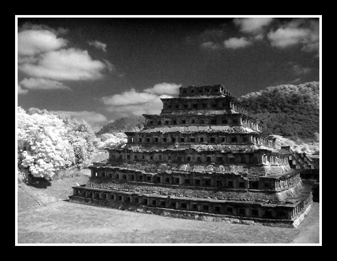
The Pyramid of the Niches has been El Tajin's defining architectural feature since its discovery during the eighteenth century. It is over sixty feet tall. Each of its six stages is deeply shadowed by out-thrusting cornices and window-like niches. The deep relief was intended to create animating effects with shadow and light as the sun crossed the sky throughout the day.
A relief panel from the northeast wall of the South Ballcourt depicts the ritual execution of a ballplayer while a death god witnesses amid swirls of smoke or mist to the left. The participants in the ritual are wearing yokes, palmas, and knee pads to protect them during play. Solid rubber balls could weigh in excess of fifteen pounds.
|
|
|
Type: Ruins
Status: Active
Accessibility: Easy
Recommendation: worth the trip
|
|
|
|
|
|
The "Plaza del Arroyo" is the first group of buildings you will appreciate when you arrive. It is the most ancient construction, featuring monumental buildings. These buildings were dedicated to Temples, Altars, Palaces as well as the Ball Courts (17 courts are located in this zone which demonstrates the importance of this site). The South Ball Court is a masterpiece in itself. It is the most expressive place thanks to the figures sculptured over its walls.
The Pyramid of the Niches. This building has 365 niches, which coincide with the number of days in the solar year. This building is solidly constructed, with a core developed through intricately integrated stonework.
|
|
|
|
|
|
|
|
|
El Tajin is a major site in the northeastern part of Mexico near the present day city of Papantla. Contemporary with later phases of Teotihuacan, it rose to its greatest height in the centuries following the collapse of the great pyramid city in the Antiplano in 750AD. Although most famous for its niche pyramid, El Tajin is also significant for its remarkable stone carvings from the North and South ballcourts. These carvings frequently depict human sacrifice and are stylistically similiar to the ballcourt carvings of the Toltec section of Chichen Itza.
Most of El Tajin is still unexcavated, and the site has been heavily looted over the centuries, as Garcia Payon, the archaelogist sent by the Mexican government in the 1930s to protect the site, discovered. He was charged with the task of stopping "this lively trade in Tajin sculptures, which were even sold in the Papantla market". However, the remains still testify to an extensive urban center whose influence must have extended for many hundreds of miles to the north, south and west.
Lindsay Jones notes that the "whole ball game complex...arose in the area of El Tajin". In the Hall of the Building Columns are several elaborate carvings depicting the sacrifice of ball players, as well as the sacrifice of more simply dressed people. "Ball players are sacrificed with lavish ceremonies...brought to the sacrifice individually, wearing their ball game equipment..." The Hall itself is a forerunner of similiar structures at Tula and Chichen Itza. And just as at Chichen, the Ball Game is central to the practice of human sacrifice. The entire Death Cult of the ball game, so prominent at Tula and Chichen, has its origins here at El Tajin.
No other site in Mesoamerica has so many depictions of ball players and their equipment. Helmets, "yokes" belts worn around the waist and "hachas" and "palmas" worn on these belts are shown in many of the carvings. Apparently, the inhabitants of El Tajin were great fans of the game. They would also appear to be overtly militaristic, not a trait that is normally associated with Classic era cultures.
It is still unknown how the game was played which hinders any understanding of how the equipment was used. Some researchers have suggested that the heavy stone yokes were actually worn during the game, but this seems unlikely given that a ballplayer could hardly demonstrate any agility with fifty pound piece of stone around his waist! The stone hachas, palmas and yokes were more likely trophies, perhaps awarded to the winners. The losers, on the other hand, may have received a death sentence, a strong incentive to remain undefeated. The ball game may have also served as a training excercise for young warriors.
El Tajin is closest to Tula of all the major sites in the Northern half of Mesoamerica. This site may have been the capital of the Nonalcos mentioned in the legends surrounding the downfall of Tula. Other legends claim that El Tajin was overrun much later in the 1200s by Chichimecs, perhaps those under Xolotl. In either case, it would be surprising if the rulers of Tula were unaware of a city the size of El Tajin so nearby. And, given the Toltecs bent towards military conquest, a clash would be inevitable.
While the artistic style employed at El Tajin is more reminiscent of their Maya neighbors, the obsessive depiction of skulls clearly finds an echo at Tula and Chichen. Likewise the heavy emphasis on human sacrifice, particularly as public spectacle. The Mound of the Building Columns certainly seems to part of the Toltec tradition of building a large multi-columned structure slightly removed from the main center. Perhaps as a military barracks? The function of this most charecteristic of Toltec buildings is still unknown, but the prescence of a Hall of Columns at Tula, Chichen and El Tajin would seem to argue for a strong connection.
Given that many parts of El Tajin clearly foredate Tula and the Toltec part of Chichen, it would seem that the influence would be El Tajin->Tula. However, it is not impossible that the Tula Toltecs may have conquered El Tajin, and then been in turn culturally influence by the inhabitants, much as the Greeks influenced the conquering Romans. The Death Cult and the Ball Game, which originate at El Tajin would certainly go on to be major facets of later Toltec culture.
|
|
|
|
|
Will stay the way it is, protected and investigated.
|
|
|
|
|
|
|
|
|
|
The moderator rating is a neutral rating of the content quality, photography, and coolness of this location.
This location has not yet been rated by a moderator.
|
|
 This location's validation is current. It was last validated by
Mutt on 3/25/2007 2:32 AM.
This location's validation is current. It was last validated by
Mutt on 3/25/2007 2:32 AM.
|
|
|
on Mar 25 07 at 2:32, Mutt validated this location
on Jul 30 05 at 16:17, lopix changed the main information
on Jul 27 05 at 13:30, lopix made this location available
on Jul 27 05 at 13:30, lopix updated a gallery picture
on Jul 27 05 at 13:29, lopix updated a gallery picture
on Jul 27 05 at 13:29, lopix updated a gallery picture
on Jul 27 05 at 13:29, lopix updated a gallery picture
on Jul 27 05 at 13:28, lopix updated a gallery picture
on Jul 27 05 at 13:28, lopix updated a gallery picture
on Jul 27 05 at 13:28, lopix updated a gallery picture
|
|
|
|
|
|
|
Is this location inappropriate / broken / missing key info?
If it's something you can fix, please scroll up and click the EDIT button.
If this location was only posted a few days ago, give the creator time to work on it.
Please try sending a message directly to the creator of the location. You'll find that info at the top of this page.
Otherwise, ONLY if you've already tried to contact the original creator,: Click here to notify an administrator.
|
|
|
|
All content and images copyright © 2002-2024 UER.CA and respective creators. Graphical Design by Crossfire.
To contact webmaster, or click to email with problems or other questions about this site:
UER CONTACT
View Terms of Service |
View Privacy Policy |
Server colocation provided by Beanfield
This page was generated for you in 140 milliseconds. Since June 23, 2002, a total of 738976309 pages have been generated.
|
|