|
|
|
UER Store
|
|
sweet UER decals:

|
|
|
|
Activity
|
|
587 online
Server Time:
2024-04-24 04:27:58
|
|
|
 |
|
|
|
|
Location DB >
United States >
Maryland >
Riverdale >
ERCO Factory
|
|
Log in to activate viewing options
|
|
|
created by Louie
on 5/28/2005 5:49 PM
last modified by Trackrunner
on 6/1/2014 12:57 AM
|
|
 |
Publically Viewable |
|
This location has been labeled as Demolished, and therefore can be viewed by anyone.
|
|
|
|
|
|
|
|
Type: Building
Status: Demolished
Accessibility: Moderate
Recommendation: forget it
|
|
|
|
|
|
Historical significance.
ERCO's only production plant.
Abandonments inside the beltway are quite the rarity.
|
|
|
fences
barbed wire
locked gates
UMD staff/trucks
|
|
|
|
|
|
|
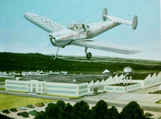
The Engineering and Research Corporation factory in Riverdale opened its doors in 1937 and, under the funding of Henry Berliner, produced the Erco Ercoupe aircraft during World War II.
The Ercoupe was an easy to fly, single engine, twin passenger aircraft that was deemed by the Civil Aeronautics Administaration as "characteristically incapable of spinning."
The world's first jet-assisted takeoff was performed using an Ercoupe.
The aircraft were thouroughly tested at the adjacent ERCO Field, which was located just south of where College Park Airport is today.
By 1947 Berliner moved out of the aircraft industry. He sold the Riverdale property and the ERCO name, as well as the Ercoupe design, to Sanders Aviation.
Sanders Aviation continued to produce the Ercoupe for five more years. While Ercroupe production at ERCO ceased in 1952, other companies continued to use the Ercoupe design untill the 1970's.
All in all, five thousand Ercoupes were produced by ERCO.
In 1954, ACF Industries Inc. purchased the property and began to produce analog flight simulators and devolping OTH radar.
In 1957, ACF merged the plant with their Nuclear Energy Products Division, thus creating the ACF Nuclear Products, ERCO division.
By 1960 the adjacent airfield was listed as abandoned on aeronautical charts.
In 1965, the property was purchased and occupied by General Precision Equipment, who quickly moved to Silver Spring in 1967.
According to "Maryland Aloft", in 1985 ACF Industries was still the owner of the former ERCO facility, but the factory was used by several federal agencies including the NOAA and the National Imagery and Mapping Agency.
Between 1989 and 2001 the ERCO Field was redeveloped, turning the overgrown airstrip into an office park.
Most, if not all of that information came from
http://www.airfiel..._MD_PG_C.html#erco
|
|
|
|
|
|
|
|
|
|
|
|
|
The moderator rating is a neutral rating of the content quality, photography, and coolness of this location.
| Category |
Rating |
| Photography |
7 / 10 |
| Coolness |
8 / 10 |
| Content Quality |
6 / 10 |
|
|
 This location's validation is current. It was last validated by
Steed on 6/3/2014 12:13 AM.
This location's validation is current. It was last validated by
Steed on 6/3/2014 12:13 AM.
|
|
|
on Jun 3 14 at 0:13, Steed validated this location
on Jun 1 14 at 0:57, Trackrunner changed the following: Recommendation
on Jun 1 14 at 0:55, Trackrunner changed the following: Status, Future Plans
on Nov 3 08 at 3:45, Opheliaism validated this location
on Jul 31 08 at 3:57, Steed conditionally validated this location
on Oct 22 06 at 5:21, morgansteph changed the following: Latitude, Longitude, Co-ordinate Accuracy, Prefer Satellite
on Dec 28 05 at 2:23, Louie changed the following: Interesting Features
on Dec 27 05 at 20:57, Louie made this location available
on Dec 27 05 at 20:56, Louie updated gallery picture 3(4).jpg
on Dec 27 05 at 20:56, Louie updated gallery picture 4.jpg
|
|
|
|
|
|
|
Is this location inappropriate / broken / missing key info?
If it's something you can fix, please scroll up and click the EDIT button.
If this location was only posted a few days ago, give the creator time to work on it.
Please try sending a message directly to the creator of the location. You'll find that info at the top of this page.
Otherwise, ONLY if you've already tried to contact the original creator,: Click here to notify an administrator.
|
|
|
|
All content and images copyright © 2002-2024 UER.CA and respective creators. Graphical Design by Crossfire.
To contact webmaster, or click to email with problems or other questions about this site:
UER CONTACT
View Terms of Service |
View Privacy Policy |
Server colocation provided by Beanfield
This page was generated for you in 78 milliseconds. Since June 23, 2002, a total of 738866540 pages have been generated.
|
|