|
|
|
UER Store
|
|
sweet UER decals:

|
|
|
|
Activity
|
|
450 online
Server Time:
2024-04-16 07:24:57
|
|
|
 |
|
|
|
|
Location DB >
United States >
Virginia >
Fort Wool >
Fort Wool
|
|
Log in to activate viewing options
|
|
|
 |
Publically Viewable |
|
This location has been labeled by its creator as Public, and therefore can be viewed by anyone.
|
|
|
|
|
|
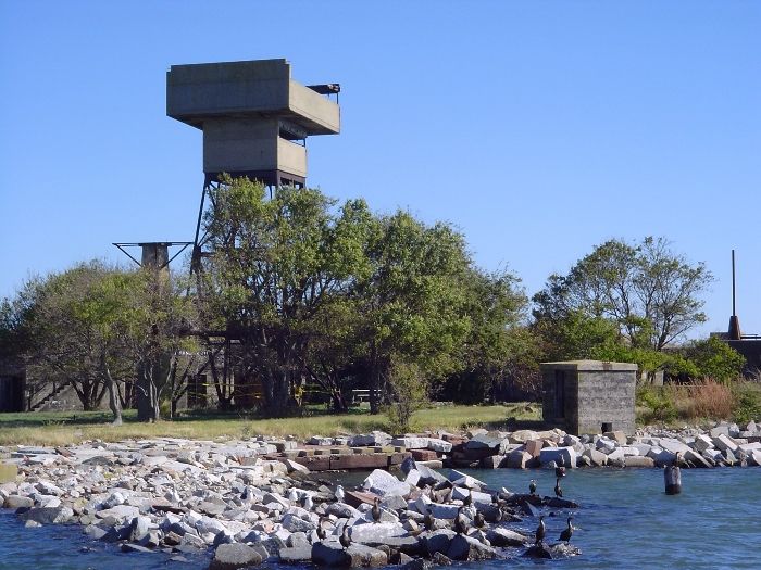
BATTERIES, BUNKERS & TOWERS:
- Battery Ferdinand Claiborne: two shielded 6-inch disappearing guns (1908-1918)
- Battery Alexander Dyer: two shielded 6-inch disappearing guns (1908-1917)
- Battery Horatio Gates: two shielded 6-inch disappearing guns (1908-1917/1942); rebuilt into 229
- Battery 229 (Battery 12): two 6-inch shielded guns (1944); gun tubes never installed
- Battery Henry Lee (Battery 13): four 3-inch rapid-fire guns (1905-1946); two guns sent in 1942 to Fishermans Is.
- Battery Jacob Hindman (Battery 14): two 3-inch rapid-fire guns (1905-1946)
- .50 calibre and 37mm Anti-Aircraft Machine Guns
- Fire Control Tower (1942) - replaced a wooden tower
- Two Searchlight Towers (1930) - replaced two 1921 wooden towers; demolished 1970's.
- Radar Tower (1943); demolished
- A.A. Searchlight Tower
|
|
|
Type: Buildings on an abandoned island
Status: Abandoned
Accessibility: Difficult
Recommendation: worth the trip
|
|
|
|
|
|
Many abandoned old buildings.
|
|
|
24 hour guard
Island, you can only get to it by boat and it is guarded.
|
|
|
|
flashlight
gloves
long pants / sleeves
|
|
|
|
The island that Fort Wool sits on is man-made. Known as the Rip-Raps, it was created beginning in 1818 on a shoal and is basically a big pile of rocks. The island continued to settle after construction of the fort began in 1826 and it was still incomplete at the start of the Civil War. The famous Robert E. Lee began his career as a military engineer, and he took part in the construction of Forts Wool and Monroe. Plans called for Castle Calhoun, the original name of Fort Wool, to have three tiers of casemates and a parapet with a total of 232 cannons. But as the island started to settle, construction stopped during the construction of the second tier. Only ten guns were mounted. 52 casemates of the first tier weren't completed until 1866.
Fort Calhoun was used before the Civil War as a summer retreat for President Andrew Jackson. In 1862, a name change was in order. Named after John C. Calhoun, President Monroe's Secretary of War and Confederate sympathizer, it was decided that it would be named after Maj. Gen. John Ellis Wool, a Mexican War hero and commander at Fort Monroe.
A very powerful experimental cannon, the Sawyer Gun, was installed here during the Civil War. The range of this weapon extended all the way to Sewell's Point in Norfolk, site of Confederate Batteries (where the Norfolk Naval Base is now located). The Sawyer Gun also fired at the C.S.S. Virginia during the famous Battle of the Ironclads in 1862. It never did any damage, however. At Sewell's Point the Confederates had built an earthen fort with bastions and a redan. There were also three other batteries. A total of 45 guns were found here (not all were mounted) by the Union forces after the Rebels evacuated.
A name change was proposed on July 15, 1874, but this never happened. The name could have been Fort Scott (after Brevet Lt. Gen. Winfield Scott), but for whatever reason the name remained the same. Seacoast Batteries were built at the turn of the century, and an aircraft radar station was here during World War II. During the World Wars it was commanded by Fort Monroe. All of the original fort, except 8 casemates, was demolished. On each of the two opposite ends of the island were searchlight towers in 1930. An anti-aircraft searchlight was located near the center of the island. A concealed radar tower was built during WWII. A submarine net closed off the harbor entrance between Fort Wool and Fort Monroe. After being decommissioned it was given to the state in 1967 and in 1970 the City of Hampton developed it into a park. The Fort Wool ferry, Miss Hampton II, allows tourists to visit the island during most of the year. But it can also be briefly glimpsed by cars entering the southern end of the Hampton Roads tunnel on Interstate 64. The island continues to settle to this very day, and occassionally the casemates of the original fortress are put off-limits for safety reasons.
|
|
|
|
|
|
|
|
|
|
|
|
|
The moderator rating is a neutral rating of the content quality, photography, and coolness of this location.
This location has not yet been rated by a moderator.
|
|
 This location's validation is current. It was last validated by
Emperor Wang on 7/21/2021 6:19 PM.
This location's validation is current. It was last validated by
Emperor Wang on 7/21/2021 6:19 PM.
|
|
|
on Jul 21 21 at 18:19, Emperor Wang validated this location
on Jul 21 21 at 18:19, Emperor Wang changed the following: Description
on Jul 21 21 at 18:17, Emperor Wang changed the following: Web Links
on Jul 20 21 at 18:19, fr00tCake changed the following: Street Address, Web Links
on Jul 20 21 at 18:18, fr00tCake changed the following: Street Address
on Jul 17 05 at 13:34, ednothing changed the main information
on Jul 15 05 at 19:59, ednothing changed the main information
on Jul 15 05 at 19:58, ednothing changed the main information
on Apr 21 05 at 13:39, ednothing changed the main information
on Oct 30 04 at 1:19, The Hitman's Daughter made this location available
|
|
|
|
|
|
|
Is this location inappropriate / broken / missing key info?
If it's something you can fix, please scroll up and click the EDIT button.
If this location was only posted a few days ago, give the creator time to work on it.
Please try sending a message directly to the creator of the location. You'll find that info at the top of this page.
Otherwise, ONLY if you've already tried to contact the original creator,: Click here to notify an administrator.
|
|
|
|
All content and images copyright © 2002-2024 UER.CA and respective creators. Graphical Design by Crossfire.
To contact webmaster, or click to email with problems or other questions about this site:
UER CONTACT
View Terms of Service |
View Privacy Policy |
Server colocation provided by Beanfield
This page was generated for you in 78 milliseconds. Since June 23, 2002, a total of 738247000 pages have been generated.
|
|