
|
Mark
      
Very Noble Donor
location:
South Carolina
Gender: Male

What is a lion, king of the savannah, when hes at the south pole?
 | |  | Aero Charts
< on 4/21/2004 8:02 AM >
|  | | | Personally I dont know why none of you have thought of this. I am a old pilot of days of yor. Ohh there is also some good details about train tracks etc.
Go to your local airport on the private airplane side. Ask then for a free aeronotical chart.
There made for each state. Look at your little legend
As you can see there are symbols for airports, military, restricted, and abandoned. Restricted may mean in private hands or historical IE maybe abandoned.
There are towers and other things for you tower freaks like me
[last edit 4/21/2004 8:04 AM by Mark - edited 1 times]
"If the threat level goes up its probably because of me." "I am looking for a girl who enjoys headbutting beltbuckles" |
|
Heartless
location:
Dakota Territory
Gender: Male

nowhere is a state of mind
| |  | |  | Re: Aero Charts
<Reply # 1 on 4/21/2004 10:04 AM >
| | | | Those are WAC charts (world aeronautical charts), and they are not so useful to UE because of the scale (1:1,000,000). You can get them for free just about anywhere, and personally, I think the only useful purpose they serve is wall decorations. I have a few Minnesota/midwest ones on my wall right now.
If you want to go the av chart way, go to any pilot shop and drop $6 or so on a sectional chart for your area. Sectional charts differ from WAC charts by being 1:500,000 - much closer, and thus much more useful. But they still don't contain much useful data other than where high radio/microwave towers are, a bit of basic topography, and like Mark said, where the train tracks are.
They're basically maps for pilots flying by basic instrumentation in clear weather or by landmarks; so I suppose one might be able to track down mines or a large complex of buildings in the middle of nowhere. But they don't list roads other than major highways, so you're still kinda screwed unless you have a GPS unit and know how to plot coordinates.
That is, unless you own a helicopter 
edit: the "restricted" airports Mark is referring to (depicted by a magenta 'R' enclosed in a cirlce) are almost always just somebody's little private grass strip somewhere. It really means private, and all that tells one from looking at the chart is that the strip can be used as a landmark for navigation or a landing place in the event of an emergency. You'd be better off looking for abandoned airports by checking the FAA's website for NOTAM's on closed airports, or try figuring out lat/long and pulling up aerial shots on terraserver. Abandoned airports will be marked with giant "X"'s on the tarmac so people don't try to land there.
[last edit 4/21/2004 10:10 AM by Heartless - edited 1 times]
"I hope that I find you in heaven, because I'm so lost without you down here..."
Lost Highway Photography |
|
Mark
Very Noble Donor
location:
South Carolina
Gender: Male
What is a lion, king of the savannah, when hes at the south pole?
| | Re: Aero Charts
<Reply # 2 on 4/21/2004 6:00 PM >
| | | | ahh more useful info I shut have put on. I found 2 runways that were abandoned It was kind of nice. Was to lazy/ tired to post all that.
"If the threat level goes up its probably because of me." "I am looking for a girl who enjoys headbutting beltbuckles" |
|
PAWolf

Not from Pennsylvania
location:
KCMO
Gender: Male

We haven't located us yet.
| |  | | | | | Re: Aero Charts
<Reply # 3 on 4/22/2004 8:32 PM >
| | | | When I was working a summer job at an airline catering dishroom I'd regularly come across outdated Jeppesen airport maps and flightcharts in the crew trash. Not really usefull to UE since they are all major airports but still cool.
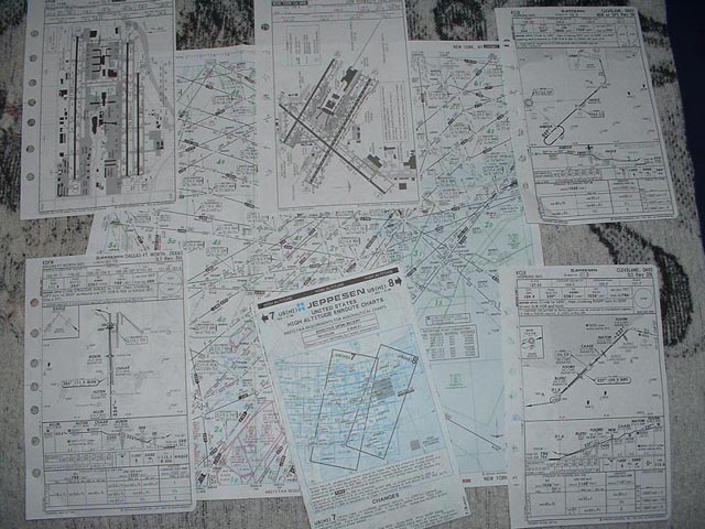
 My favorites are the approach pictures. My favorites are the approach pictures.
Make Beer, Not War. |
|
orangeindiana
Noble Donor
location:
Texas
Gender: Male
Meh.
| | Re: Aero Charts
<Reply # 4 on 4/25/2004 9:54 PM >
| | | | Ugh. I worked a temp job, stuffing Jeppesen charts into envelopes for pilots for eight hours a day at their center in Denver Tech Center. Demanded a transfer after the second day; it was mind-numbing. If anybody passes through south metro Denver, though, if you stop by their place they're usually happy to share a copy with you. It's located in Inverness business park, right nearby Arapahoe and Peoria (across from the Family Fitness Center).
|
|
SnArF

| | Re: Aero Charts
<Reply # 5 on 5/11/2004 4:29 PM >
| | | | You can also by Jeppesen plates, approach Plates, NAS Plates and IFR/VFR plates like these online, the'll cost you though.
|
|
null_recipe
location:
Portland, Oregon
Gender: Male

| | Re: Aero Charts
<Reply # 6 on 5/12/2004 5:23 AM >
|  | | | What about US Geological Survey Maps?
|
|
Powered by AvBoard AvBoard version 1.5 alpha
Page Generated In: 60 ms
|
|


