
|
Captain Obvious
    
location:
among the tank farms
Gender: Male

in ur xbox...there are midgets
 | |  | How to find railroad ROWs with Google Earth
< on 8/24/2006 8:58 PM >
|  | | | The 3 Signs of Abandoned Railroads
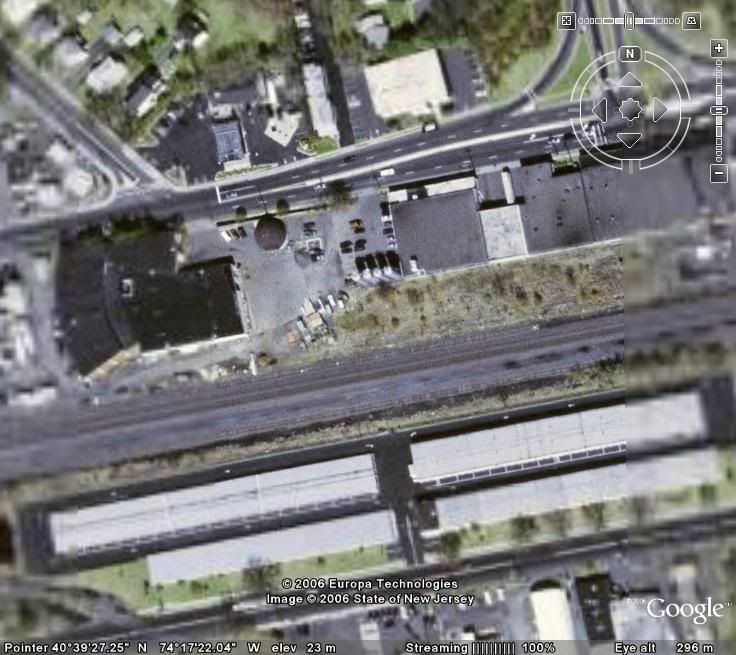
First, an active line. You can see how the roadbed is wide and clear, with multiple intact tracks.
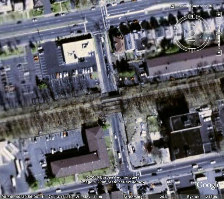
1. Unexplained lines breaking up street grids. These strips of green or gray usually signify a ROW where the tracks have been removed, buried or grown over.
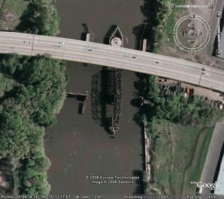
2. River bridges with nothing, or an aforementioned unexplained line, on either side. Abandoned swing bridges are usually in the open position.
3. Overpasses with nothing on them.
Nov. 24, 2007--The city of Cleveland, Ohio, announces that it has developed tactical nuclear weapons, and does not wish to hear any more jokes.
|
|
SoupForDummies

| | Re: How to find railroad ROWs with Google Earth
<Reply # 1 on 8/25/2006 3:01 AM >
|  | | | 1. What's an ROW?
2. It's kind of hard to see what you're talking about in some of those pics.
3. That seemed kind of anti-climactic...
zzzzzzzzzzzzzzzzzzzzzzzzzzzzzzzzzzzzzzzzzzzzzzzzzz |
|
'Dukes

Noble Donor
Gender: Male

At least someone llikes me
| |  | Re: How to find railroad ROWs with Google Earth
<Reply # 2 on 8/25/2006 3:13 AM >
| | | | "rights of way" Soup, and he is correct those are good signs, but it is usually easier when you are searching for a non extant line.. then you will look for these signs after you have some inkling of what USED to be there... very cool. What with the old short lines we used to have up here in the woods, I'm finding myself becoming a railfan very quickly.. one goes to my ex favorite ex place.
I got your tour winner right here pussies, at least he'd crash out trying. |
|
blackhawk

This member has been banned. See the banlist for more information.
location:
Mission Control

UER newbie
| |  | Re: How to find railroad ROWs with Google Earth
<Reply # 3 on 8/25/2006 3:29 AM >
| | | | RR follow rivers and streams many times; routes that are close in elevation, or change gradually. Old abandoned lines appear sometimes as a thin line of trees, and many parallel highways or roads.
Just when I thought I was out... they pulled me back in.
|
|
JimBoylan
 
location:
SouthEast Pennsylvania, U. S. of A.
Gender: Male
| | Re: How to find railroad ROWs with Google Earth
<Reply # 4 on 8/25/2006 1:35 PM >
| | | | "Right of Way" is a more general legal term than "owned property". A railroad (or other organization) may not own the land on which it has the "right" to lay its tracks and operate its rail "way".
|
|
nostra-YOUPPI!

Umpire
location:
Shahre:'on Kaybec

Bonsoir et cest partie
| | Re: How to find railroad ROWs with Google Earth
<Reply # 5 on 8/25/2006 1:55 PM >
| | | | Posted by 'Dukes
"rights of way" Soup, and he is correct those are good signs, but it is usually easier when you are searching for a non extant line.. then you will look for these signs after you have some inkling of what USED to be there... very cool. What with the old short lines we used to have up here in the woods, I'm finding myself becoming a railfan very quickly.. one goes to my ex favorite ex place.
|
in your area the line that used to join rouses point to burlington has been gone for years but its right of way is still quite evident, to the vacant but noticeable wye in rouses point to the bridge across lake champlain and the multiple causeways
Montreal Expos 1969-2004 Forever Proud Lets Keep The Dream Alive |
|
Captain Obvious
location:
among the tank farms
Gender: Male
in ur xbox...there are midgets
| | Re: How to find railroad ROWs with Google Earth
<Reply # 6 on 8/25/2006 8:27 PM >
| | | | 1. What's an ROW?
2. It's kind of hard to see what you're talking about in some of those pics.
3. That seemed kind of anti-climactic... |
1. Right Of Way.
2. My internet connection is crap, so I have to use the cache to see anything.
3. How, pray tell?
Nov. 24, 2007--The city of Cleveland, Ohio, announces that it has developed tactical nuclear weapons, and does not wish to hear any more jokes.
|
|
SoupForDummies
| | Re: How to find railroad ROWs with Google Earth
<Reply # 7 on 8/27/2006 1:45 AM >
| | | | Sorry if I'm coming off like a jerk, I'm just confused.
Why would you want to find these, do they lead to anything or are they just grown over rail tracks?
zzzzzzzzzzzzzzzzzzzzzzzzzzzzzzzzzzzzzzzzzzzzzzzzzz |
|
fedge
location:
Gaud Corners, Ontario, Canada
Gender: Male

you blight up my life™®
| | | Re: How to find railroad ROWs with Google Earth
<Reply # 8 on 8/27/2006 12:26 PM >
| | | | otonabee has done some detailed research on this line, east of Toronto. Much of it has been turned into bike trails and some of the station houses exist as private homes to this day.
18-odd Years Of UER-ing! |
|
Geo

| | Re: How to find railroad ROWs with Google Earth
<Reply # 9 on 8/27/2006 1:51 PM >
| | | | FWIW, i just grab a topo of the area i'm interested in. on most topos rr row's are usually marked "abandoned XX&X railroad" for the ones that arent used. Also topos usually include paper streets. Seems easier to me.
GV
|
|
JimBoylan
location:
SouthEast Pennsylvania, U. S. of A.
Gender: Male
| | Re: How to find railroad ROWs with Google Earth
<Reply # 10 on 8/28/2006 12:22 PM >
| | | | | Posted by SoupForDummies: Why would you want to find these, do they lead to anything or are they just grown over rail tracks? |
Often, urban areas and railroads are attracted to each other, then when one dies, the other often does too. So, following abandoned railroads, even if they don't interest you, can lead to abandoned urban explorations that may be interesting and also "off the beaten path".
|
|
nostra-YOUPPI!
Umpire
location:
Shahre:'on Kaybec
Bonsoir et cest partie
| | Re: How to find railroad ROWs with Google Earth
<Reply # 11 on 8/28/2006 12:23 PM >
| | | | Posted by DanB
The 3 Signs of Abandoned Railroads
First, an active line. You can see how the roadbed is wide and clear, with multiple intact tracks.
|
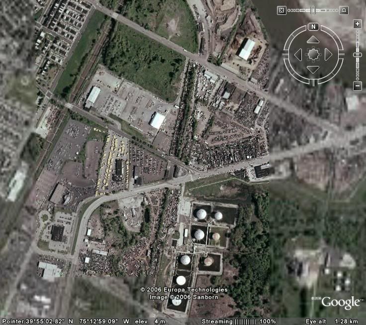
i just noticed the remains of a roundhouse in this pic
Montreal Expos 1969-2004 Forever Proud Lets Keep The Dream Alive |
|
JimBoylan
location:
SouthEast Pennsylvania, U. S. of A.
Gender: Male
| | Re: How to find railroad ROWs with Google Earth
<Reply # 12 on 8/28/2006 12:33 PM >
| | | | The swing bridge in the 2nd photo of this thread is on the former main line of the Philadelphia, Wilmington & Baltimore RR. Allan Pinkerton and Abraham Lincoln rode here on the way to his 1st inauguration. Notice the foundation for the old Gray's Ferry Rd. swing bridge North of the new fixed highway bridge.
|
|
Free Baller
location:
New Jerssey
Gender: Male

I have a friend in Jesus. Seriously, Jesus ate my friend. It was horrible.
| | Re: How to find railroad ROWs with Google Earth
<Reply # 13 on 8/28/2006 5:19 PM >
| | | | Cool tutorial, maybe you should circle some of the stuff to make it clearer.
Trying to win hearts and minds, but willing to splatter them if neccesary.
|
|
z0th
location:
/dev/urandom
Gender: Male

On the bleeding edge of cocking things up.
| | | Re: How to find railroad ROWs with Google Earth
<Reply # 14 on 8/29/2006 6:45 PM >
| | | | Posted by Free Baller
Cool tutorial, maybe you should circle some of the stuff to make it clearer.
|
ill second that.
gallery | deviantart | flickr |
|
Bill Cosby
| | Re: How to find railroad ROWs with Google Earth
<Reply # 15 on 8/31/2006 10:19 PM >
| | | | I also like to add that if you know of a track somewhere in your area, chances are you can find it on google earth. From there you can follow it until you come to the nearest freight yard or division. This could prove to be very useful for anyone looking into catching a freight. So far I've found a couple.
Check out this one.

|
|
Powered by AvBoard AvBoard version 1.5 alpha
Page Generated In: 93 ms
|
|


