
|
|
At this time Google earth does not provide a high resolution view of our area but there are two other sources you may reference
City of Peterborough interactive map:This map provided on the city of Peterborough website provides an aerial view in black and white with an image that is dated 1996
Image of GE plant from city website
County Peterborough GIS map: Another view of Peterborough this time found on the County of Peterborough website. It will provide you with a colour image of the county and the city. The images are dated 2002. I prefer this site over the city site because of the images being less dated and in colour
This is the county website image of GE. This image is much more blurry than the actual website image (I messed up somewhere along the way)
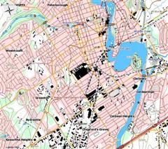
Toporama website: Another source of Topo imaging is this site. Smaller buildings are not indicated in large populated areas but are indicated in the rural areas and there is no aerial imaging with this site
There is also a map making feature on the Government of Ontario website
in the Land information Ontario section
Ontario government topo map maker

Calvin: It's a magical world, Hobbes, Ol' Buddy . . . let's go exploring!
| |
I noticed that the city of Peterborough and some of Peterborough county are now high resolution on Google earth. It is a winter view and the quality does not match up to the view i enjoy from google earth of my new home town /area (Bowmanville/Durham region) but at least you can make out houses and other objects now
Calvin: It's a magical world, Hobbes, Ol' Buddy . . . let's go exploring!
| |
Odd they'd employ a winter view. The Peterborough and area on Google Maps still sucks, even zooming in on the city itself.
18-odd Years Of UER-ing! |
Add a poll to this thread
This thread is one of your Favourites. Click to make normal.Click to make this thread a Favourite.

| This thread is in a public category, and can't be made private. |
Powered by AvBoard AvBoard version 1.5 alpha
Page Generated In: 46 ms
|
|


