|
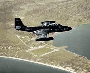
The final resting place of a '50's era US Navy fighter.
A squadron of fighters was flying to Moffet Field in heavy fog. Their leader was flying too low and struck redwood trees. Neighbors heard the crash and contacted authorities. The sheriff found the site in the early morning and the pilot's remains were recovered and returned home.
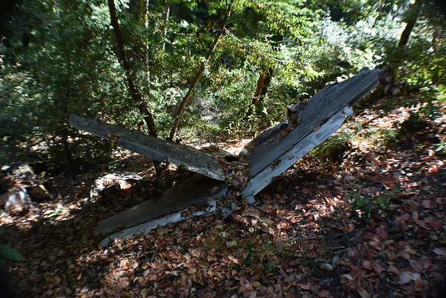
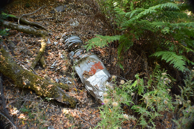
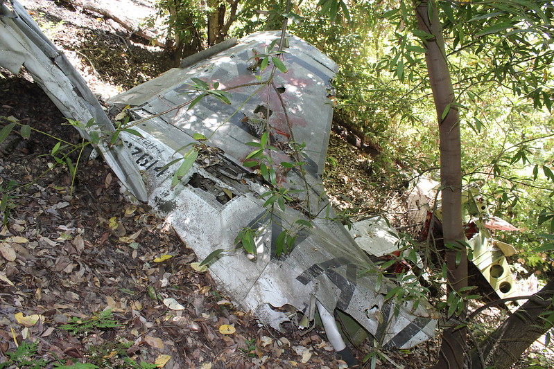
Coming up to the site from the north you see the impact crater and the tail section.
1.
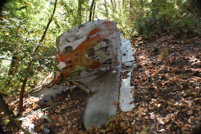
If you look close you will notice a brass engraved plate on the left side of the vertical stabilizer. It was attached by some respectful wreck chasers.
2.
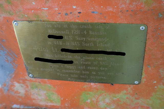
Engraved plate, redacted for protection of the site
3.
Further downslope. Part of what I suspect is the landing gear assembly.
4.
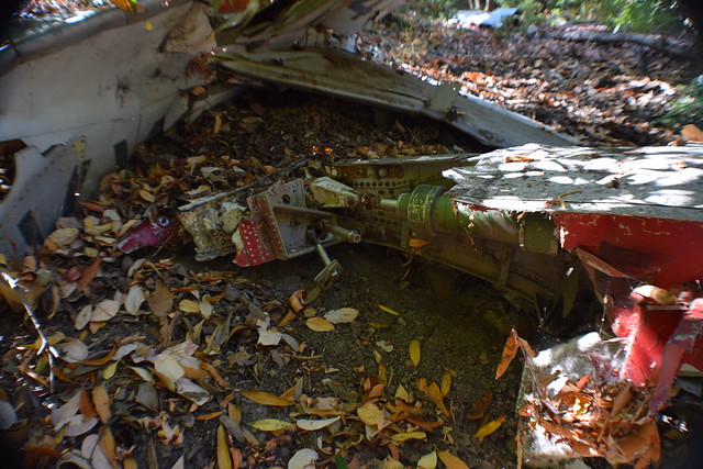
Deeper in the ravine are most of the heavier parts of the plane, including both engines that separated from the fuselage at impact.
5.
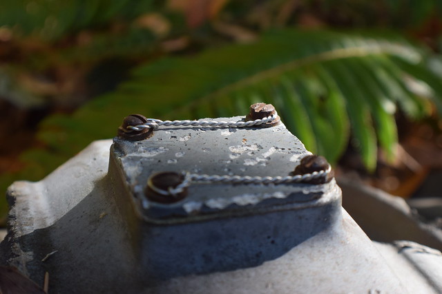
Super professional safety wiring on engine
6.
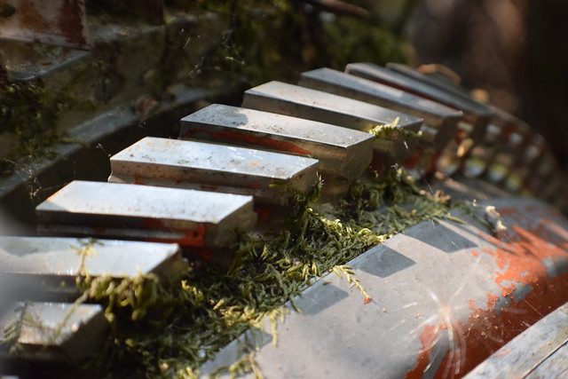
Beautiful anodizing
7.

Machined alloys and moss
8.
Visit while you can. Unfortunately, stupid bay trees are continuing to fall all over this crash site. They have started to obscure portions of the site and wreck bits of the wreck.

Its a dog eat dog world out there, and sometimes, its the other way around. |
|
Wow, this is super cool!
|
|
Cool but might as well post all info in a FM members only thread. but might as well post all info in a FM members only thread.
Took me less then 5 minutes to find her...
A beautiful warbird.
[last edit 6/3/2018 2:06 AM by blackhawk - edited 1 times]
Just when I thought I was out... they pulled me back in.
|
|
My brother who is not an urban explorer but an avid hiker stumbled upon this somewhat recently. Your pictures are much more interesting than his. Awesome!
Curiosity killed the cat, but the cat had fun. voiddiver.com |
|
how tough is the bush whacking ?
http://www.flickr....rescueme1060/sets/
|
|
| how tough is the bush whacking ? |
It's not too bad actually. You can choose a line where you might duck under or through a few trees and bushes, but that's it.
| My brother who is not an urban explorer but an avid hiker stumbled upon this somewhat recently. Your pictures are much more interesting than his. Awesome! |
Thanks! I had to go here once I found out about it and located it. Well worth the trip.
Agreed. It's a pretty sobering place to be in.
Its a dog eat dog world out there, and sometimes, its the other way around. |
|
Easy urban explore here. The hike alone is time consuming ( Seven and a half hours total walking time). I started at Skeggs Point in the El Corte De Madera Creek Open Space Preserve and followed the Resolution Trail which was built to access the DC-6 debris areas. Plane crashed on Thursday, October 29th and all 19 passengers were killed.
There is also a stealth bomber crash site in Bakersfield near Kern River Canyon. My friend completed the rigorous hike near Saturday Peak. The photos were quite impressive. The permanent marker of the crash site has a flag pole, american flag, and a stealth bomber steel ornament on the top of the pole.
Cody here exploring everything! |
|
Posted by goldengateurbex
Easy urban explore here. The hike alone is time consuming ( Seven and a half hours total walking time). I started at Skeggs Point in the El Corte De Madera Creek Open Space Preserve and followed the Resolution Trail which was built to access the DC-6 debris areas. Plane crashed on Thursday, October 29th and all 19 passengers were killed.
|
Totally different crash than what is posted here, just FYI
http://www.flickr....rescueme1060/sets/
|
|
Years ago Weird NJ posted images of a plane crash site in West Milford. Just Google the phrase "jet in the woods"...
|
|
"how tough is the bush whacking ?" followed up with, "Totally different crash than what is posted here, just FYI". Clearly you have not visited the site FYI
Cody here exploring everything! |
|
You’re right. I haven’t visited this site that’s why I asked the OP a question.
The information you gave out is not accurate when it comes to this specific aircraft.
http://www.flickr....rescueme1060/sets/
|
|
Posted by goldengateurbex
Easy urban explore here. The hike alone is time consuming ( Seven and a half hours total walking time). I started at Skeggs Point in the El Corte De Madera Creek Open Space Preserve and followed the Resolution Trail which was built to access the DC-6 debris areas. Plane crashed on Thursday, October 29th and all 19 passengers were killed.
There is also a stealth bomber crash site in Bakersfield near Kern River Canyon. My friend completed the rigorous hike near Saturday Peak. The photos were quite impressive. The permanent marker of the crash site has a flag pole, american flag, and a stealth bomber steel ornament on the top of the pole.
|
Hey goldengateurbex, this thread is about a crash site of a particular naval fighter jet.
But for some reason you're going on about a different crash site that involves a DC-6 airliner, and then again about the crash site of a bomber (that you apparently only saw pictures of).
Why not just start your own thread w/pictures about the other crash site you want to talk about?
[last edit 6/11/2018 8:11 PM by dtewsacrificial - edited 1 times]
|
|
Posted by dtewsacrificial
Hey goldengateurbex, this thread is about a crash site of a particular naval fighter jet.
But for some reason you're going on about a different crash site that involves a DC-6 airliner, and then again about the crash site of a bomber (that you apparently only saw pictures of).
Why not just start your own thread w/pictures about the other crash site you want to talk about?
|
Hey Dtew,
thanks for the feedback. Unfortunately your assumptions are off. The naval plane your talking about is walking distance from [entry details removed]. Lots of hikers. Look out for the poison oak. If anyone wants to view this site send a DM.
[last edit 6/12/2018 3:19 AM by Boffo - edited 1 times]
Cody here exploring everything! |
|
Are you MtnManDan? Giving away a location to the general public is something that guy did a lot and was banned 6 times.
I'll be contacting a mod to have your above comment deleted.
http://www.flickr....rescueme1060/sets/
|
|
This crash site was discussed on the message board here over 10 years ago, I believe this is a relatively well known crash site, and only the fact it's not an easy hike in and out keeps it relatively unmolested. Even with minimal information, it's pretty easy to search out online, but hiking around and finding it, without exact GPS coordinates is another matter...
Touching on one of the other aircraft crash sites mentioned, the Resolution DC-6 near Kings Mountain which killed 19 people, that site has had numerous pieces removed since the trail cuts right though the impact site.
Jeff
|
|
I ended up completely missing the two engines
 2018-06-16 12.34.27 by rescueme1060, on Flickr 2018-06-16 12.34.27 by rescueme1060, on Flickr
http://www.flickr....rescueme1060/sets/
|
|
such a strange nice find..thanks for sharing!
|
|
Was able to check out this location a few days ago. Seems some things have changed since these photos from last year were posted. I’ll throw together some of my stuff in a thread later today.
[last edit 6/20/2019 7:01 PM by cleipelt - edited 2 times]
|
|
Wow, I need to figure out exactly where it is and go take a look.
|
|
cool find man
|


