
|
|
Hello, I was wondering if any of you use some kind of map, or something related, to keep track of the locations you find. Personally, I use a google maps list, but I was wondering if there was a more efficient or generally better way to do so.
Edit: Grammar
[last edit 6/2/2018 12:41 AM by S&J Explore - edited 1 times]

I'm here for a good time not a long time. | |
I just use notepad, keep things organised by city and weather or not its N S E OR West for my main location.
That way if I want to go east that day I can explore towns and city's in that direction and vice versa.
After I have explored somewhere I still keep it on my list and just mark as completed that way I dont explore same place twice. Unless its worth it of course.
Hope that helps in someway for you.
@Forgotten_Productions_416
Follow Us On Our YouTube Channel As We Explore These Amazing And Beautiful Finds!
LINK BELOW:
https://www.youtub...HUAx9iVMn1unDv1JA? | |
I've honestly been using an excel spreadsheet, I have the location name, the address or what its by, current status of the location, and any other general info I should keep track of before going down the list of explores.
| |
Google mymaps, make sure you have share by link off.
| |
Posted by Pear
Google mymaps, make sure you have share by link off.
|
Seconded. I have a map with lots of information that can be determined at a glance. For example, I have multiple layers, each one corresponding to an abandonment type:
- Residential/Agricultural
- Commercial
- Industrial
- Public Institutions (schools, churches, etc)
- Infiltration (drains, tunnels, and rooftops)
Each location is marked with a pinpoint. The shape shows the status- a pin for a standing location, a diamond for a demolished/renovated location. The color shows how accurate my information is- green for "already explored," yellow for "verified but unexplored," and red for "unverified potential lead." The shade further denotes how up-to-date that information is: dark if it has been verified within the last year, light if not. Lastly, each point has a comment section where I can write any specific information about that location- hazards, history, notable features, exterior photo, etc.
Take this map for example, with four random points (that don't correspond to real locations) for demonstration purposes.
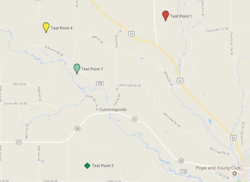
Test point 1: Unverified potential abandonment
Test Point 2: Explored verified abandonment, still standing. Presence last verified over 1 year ago
Test Point 3: Explored verified abandonment, demolished. Verified within last year.
Test Point 4: Unexplored verified abandonment, still standing. Verified within last year.
It looks complicated at first glance, but with it, I can tell so much about a location just by looking at its map entry, and the color coding helps to show the important information at a glance. Google Maps is a powerful tool.
[last edit 6/2/2018 4:44 AM by Aran - edited 2 times]
"Sorry, I didn't know I'm not supposed to be here," he said, knowing full well he wasn't supposed to be there.
| |
I have a map of locations locally on Google Earth, because I was frustrated by the small limit on "layers" you could have on one map. Before things go onto my map though, they usually start out as a note on my phone.
One day I got a good camera.
https://www.flickr...hotos/fleetsurbex/ | |
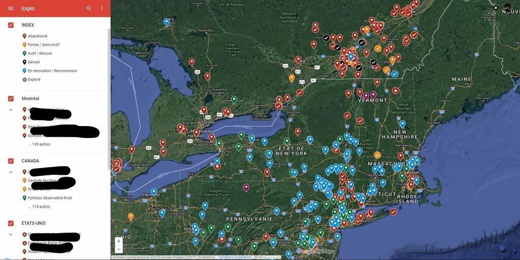
Imo, the best way ever is on google My Maps.
You can create different layers (like subfolders) example; canada, united state, europe etc.
You can also change color and style of the pins and add informations and picture s.
 [/URL] [/URL]
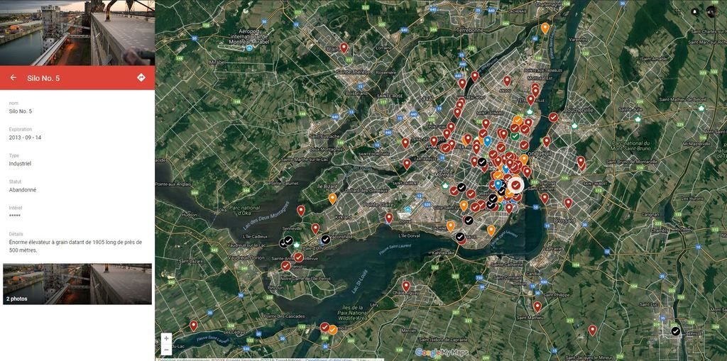
Here is an example if i click on one of my spot, you can add wathever information that you want, for each layer you just need to fill the 'form' that you created.
 [/URL] [/URL]
Il y a toujours un moyen. | |
if you can just share that map with me that would be great.
Thanks in advance

http://www.freaktography.com
https://www.facebook.com/Freaktography https://instagram.com/freaktography www.youtube.com/c/Freaktography | |
I use the UER LDB.
| |
Google Maps or Earth is literally all you need.
I think I started my locations maps soon after I began exploring to keep track of where I've been and where I want to go, it's the easiest and simplest tool for the job. I've got separate maps for the UK, USA as well as a European one which is hopelessly outdated as I haven't been over there in four years now.
Just for the love of all that is holy make sure it's set to private.
| |
Posted by Steed
I use the UER LDB.
|
Works great... if you have full membership, if not in my town there’s NOTHING I’ve been able to find.
| |
Posted by 204urbex
Works great... if you have full membership, if not in my town there’s NOTHING I’ve been able to find.
|
Since it works so great, why don't you demonstrate that you deserve access to it? Two posts and complaining that there's nothing around you isn't getting you full membership.
One day I got a good camera.
https://www.flickr...hotos/fleetsurbex/ | |
Posted by Freaktography
if you can just share that map with me that would be great.
Thanks in advance
|
Fuck off in advance, thanks 
Il y a toujours un moyen. | |
Posted by ClementRSedona
Fuck off in advance, thanks
|
hhahahah Taberbac! You french fuck!!
http://www.freaktography.com
https://www.facebook.com/Freaktography https://instagram.com/freaktography www.youtube.com/c/Freaktography | |
Posted by Freaktography
câlise donnes-moi ce map si tu plais tabernac
|
Fixed it for you.
One day I got a good camera.
https://www.flickr...hotos/fleetsurbex/ | |
Thanks everyone for the advice. I've decided to use MyMaps.
I'm here for a good time not a long time. | |
Posted by Fleeting
Fixed it for you.
|
hahaha almost there! Swearing in french canadian is an art! loll
[last edit 6/5/2018 5:10 AM by Urban Downfall - edited 1 times]
Il y a toujours un moyen. | |
Posted by 204urbex
Works great... if you have full membership, if not in my town there’s NOTHING I’ve been able to find.
|
Not even then, really. Database accuracy varies greatly depending on the local urbex community. Where some cities have multiple explorers keeping their local part of the DB up to date, there are also entire states where the only information are a few locations provided by some long-retired explorer ten years ago. If you want to make the DB a reliable resource, you have to do it yourself.
The way I see it, doing so helps the community as a whole and helps new explorers dip their toes in the water of the FM community- after all, now that many of the old "rites of passage" locations that everyone explored are gone, there needs to be something to take their place.
"Sorry, I didn't know I'm not supposed to be here," he said, knowing full well he wasn't supposed to be there.
| |
This might seem a little excessive but I keep a binder with details, history, maps and photos of all of the locations I have found!
| |
Posted by Fleeting
Since it works so great, why don't you demonstrate that you deserve access to it? Two posts and complaining that there's nothing around you isn't getting you full membership.
|
I’ve actually been trying to find anybody from Winnipeg that has been active in the last few months, as for post counts, I feel that since I’m very new to the scene, I’d rather not post senseless comments on other people’s threads. If I have something to say, however, I most likely would share my thoughts. Have you been to Winnipeg in the last ten years? There’s not that much here that I know of, and I’m unable to travel to the nearest meet ( usually Toronto).
|
Add a poll to this thread
This thread is one of your Favourites. Click to make normal.Click to make this thread a Favourite.

| This thread is in a public category, and can't be made private. |
Powered by AvBoard AvBoard version 1.5 alpha
Page Generated In: 93 ms
|
|


