
|
|
I use google earth to confirm locations so I can add them to my personal database. Google "pinnable maps" and the first website called "zeemaps" is what I use. You can pin locations and save them and it's super quick and fast. You can even color code your points. I use the numerous points to signify how exciting, interesting, or great a place looks or is. I'd encourage y'all to check it out! Even has sat view (:
Edit: Here is the link to the site: https://www.zeemaps.com/
Creating an account is super easy. Just put in your email and a password then hit "create account" and you got your account created.
[last edit 5/12/2016 8:35 PM by Landser - edited 1 times]

Before jumping to conclusions, I'm not a Nazi. | |
Posted by TD
1. Plant growth is huge. In rural areas especially, abandoned buildings aren't going to have anyone on landscaping duty. If you see tall grass, overgrown bushes, anything like that, it's a good sign. Inversely, trimmed bushes and a manicured lawn are a sure sign that the area is occupied.
|
This is generally true, but I can think of several instances where rural abandonments had mowed lawns and such. Out in the country, neighbors are both vigilant and willing to help make a place look less abandoned from the road.
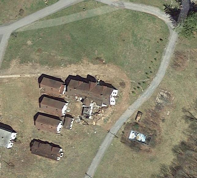
Here's a good example:

(photo by bluebeamsky)
| |
I have 10 acres. I only mow and landscape about 2. Googlearth that and come up here in my woods some night you'll see just how abandoned I consider it. 
| |
This website has helped me a time or two with addresses.
https://ctrlq.org/maps/address/
I'm trying to figure out how to track down a land owner when I cant find an address and nothing shows up in the CAD on that road.
I could wander around and wait for the shotgun blast. lol
| |
Posted by NeuroticMatt
This website has helped me a time or two with addresses.
https://ctrlq.org/maps/address/
I'm trying to figure out how to track down a land owner when I cant find an address and nothing shows up in the CAD on that road.
I could wander around and wait for the shotgun blast. lol
|
Some county "online" appraisal departments are notoriously lousy and inaccurate especially rural and less affluent ones. Typically they have a big map (on paper) you can go in to use otherwise you will need a geocode or maybe a tax ID number. real estate guys know how to do that. And if you walk in and ask they are obliged to show it to you. Don't be surprised if they want to know why or ask if youre a resident after all they have a high and powerful position as a county clerk and like to be sure nobody finds a property line unless they deserve it! .
(try researching mineral rights sometime they treat you like a terrorist)
| |
Posted by 2Xplorations
Some county "online" appraisal departments are notoriously lousy and inaccurate especially rural and less affluent ones. Typically they have a big map (on paper) you can go in to use otherwise you will need a geocode or maybe a tax ID number. real estate guys know how to do that. And if you walk in and ask they are obliged to show it to you. Don't be surprised if they want to know why or ask if youre a resident after all they have a high and powerful position as a county clerk and like to be sure nobody finds a property line unless they deserve it! .
(try researching mineral rights sometime they treat you like a terrorist)
|
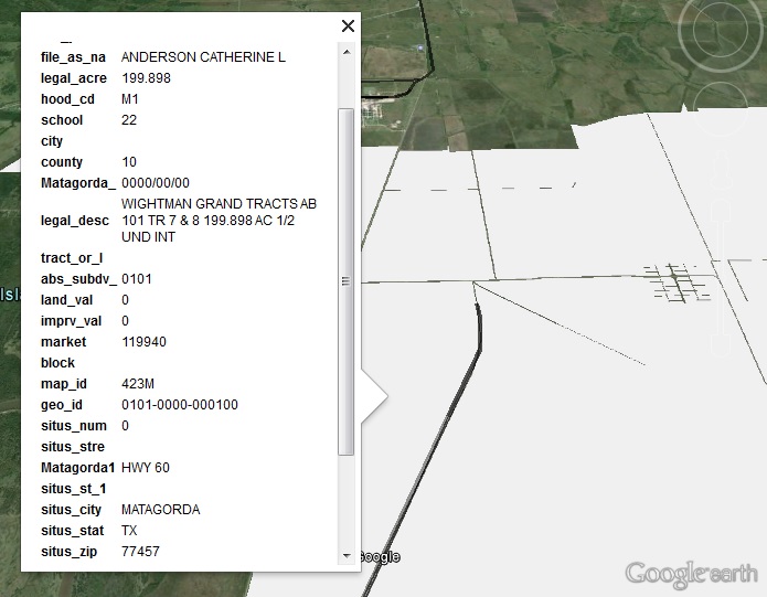
I ended up downloading the GIS data from the county site and importing it into Google Earth Pro (Free now) and it listed the property information including owners, and owners address.
Here is a sample from another area. (That's right, I am not sharing my spot! lol)
What I did find out though was that the owner lives in another city, actually owned by an LLC. I feel like they would be more likely to say no to a request. Less likely to know if I go out there, though the odds are high that they lease the property to locals for grazing rights, back to the shotgun option. Dangit.
1.
| |
Posted by TD
For potentially abandoned rural locations, I've found a few things can tell you a lot about a building. Most of them are common sense...
|
This was really helpful, TD. Thanks.
Ter Beatus | |
I'm still new here so this might be useless advice, but I'll throw it out there...
I'm a fan of Google Maps and have used it a lot, but lately have been using Bing Maps, particularly the Birds Eye View, as well.
The satellite views are different so you get an idea if the site is active or not, and then the factories that have old looking roofs yet are completely active and maintained are always tricky. The Birds Eye View adds a LOT to that equation as you can see it's well kept other than it's roof.
When exploring online now, I start in Google Maps as that's what I'm used to, right click on the exact area to get the coordinates, plug them into Bing Maps, and get a "second opinion".
For what it's worth, the original post looked like a scrapper's/hoarder's compound that would likely introduce themselves to me with a shotgun and I wouldn't even consider going there
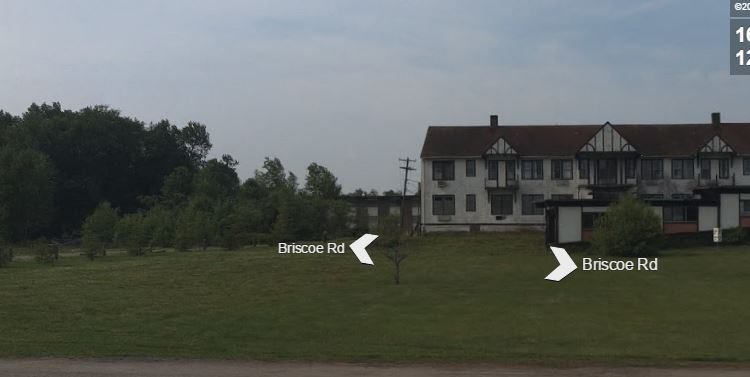
For illustration purposes, here are a bunch of pictures for a famous location that has been in a state of demo/repurposing for a while. There are Google Sat and Street views, as well as Bing Sat, Street, and Bird views. Sorry for the crappy cropping and stuff, but trying not to break too many rules about locations...but the "step ladder" buildings in the very front are gone, and the big white building by them is LONG GONE (aka - I never saw it standing). These are current screen caps taken right now that show how active a site it is, and if you just went to one and saw the "step buildings" and made a big trip to see them, you'd be really upset. Trust me, been there and done that. The more sources you can use, the better off you are.
1. Everything is there
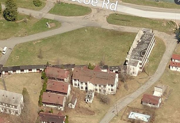
2. Seperate white building is gone, stair buildings still there
3. Everything is there
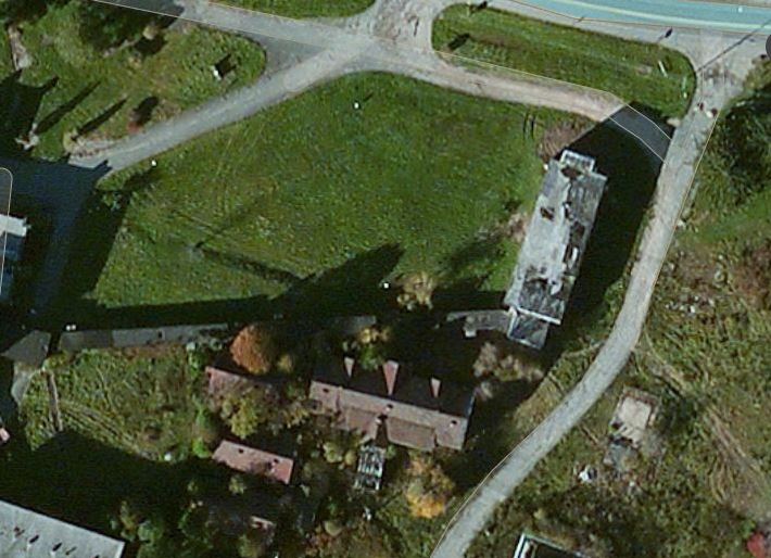
4. White building and stair building are both completely gone
5. Every thing is there
| |
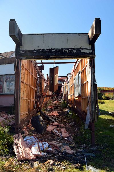
BTW - A pic I had put in the NE Pic of the Day thread...from last fall when I went to this location, this is the "step building" in an odd stage of demolition. The "white building" was looooong gone and I couldn't even tell it had ever been there.
1.
[last edit 7/28/2016 1:13 AM by oysterhead00 - edited 2 times]
| |
Heyyo. I have found using Google Maps (Street View) to be not very useful at all when finding new abandoned places. However when locating old abandoned places for validity, Google Earth is wonderful. It saved me countless hours of missioning out to places that were no longer there from demolition or had burned down. A word of caution: places that I have thought were abandoned sometimes weren't actually abandoned though, so be careful with that. People are still living in some of those kinds of places.
[last edit 7/29/2016 8:20 PM by trublemak3r - edited 1 times]
| |
For anyone behind the times, Google Earth Pro is now free. I highly recommend upgrading, or if you've never used GE before, downloading:
https://support.go...nswer/176160?hl=en
The promo code for this once-pricey tool is: GEPFREE
Tip: Take advantage of the date feature in the lower right hand corner of the imagery. This will give you an idea of the image's likelihood of accuracy.
Lastly, be sure to utilize the "Historic View" option in the upper left and/or in the drop-down menu. This has been an invaluable feature in my research.
I wandered till the stars went dim. | |
Sweet, thanks! Downloading and installing now!
| |
Posted by YotaMan20
Worth the drive? Hard to tell.
|
The image resolution can vary significantly between locations. A lot of rural areas do not have the high resolution raw data available for middle of the city.
| |
Posted by TD
I find pretty much all of my locations on Google Earth. Those that I haven't found through google earth I've found while driving to somewhere I found through google earth.
...
For potentially abandoned rural locations, I've found a few things can tell you a lot about a building. Most of them are common sense.
1. Plant growth is huge. In rural areas especially, abandoned buildings aren't going to have anyone on landscaping duty. If you see tall grass, overgrown bushes, anything like that, it's a good sign. Inversely, trimmed bushes and a manicured lawn are a sure sign that the area is occupied.
2. Also look out for a lack of paths towards the building in question. If plants have overgrown the path to the building, or better yet if there is no visible path the building, it's a very good sign the property is abandoned.
3. Use street view when you can. Many rural areas don't have any street view data but it's always worth checking. It's pretty easy to tell whether or not a location is abandoned on street view.
4. Always look for the obvious stuff too. Caved in roofs or holes in the wall means the building legally can not be occupied.
5. Rusted roofs will catch your attention, but they're a very poor indicator of whether or not a building is inhabited. If it were me making the decision and the only indicator of vacancy were a rusted roof, I wouldn't do it.
6. If you're not sure about a location, google it (if it looks big enough to come up on google). Use street view to find building/company names. If that's not an option, and it often isn't, google the address. The address will typically turn up a company/owner name which can then be googled to get more information and boom suddenly you're a historian on the place.
7. Look for cars. If there is a car there that looks like it could move, it's probably got a driver. If there's not a car there, the place could be vacant. I personally use google maps satellite view, not google earth, but google earth, I believe, has a function where you can look up the date and time when the image you are looking at was taken. That might not be true, but if it is that information could be used to your advantage. If the picture was taken early in the morning or late at night, or on a weekend, and there's no car, that's a better indicator of vacancy then if it's at noon on a Tuesday.
...
|
Hey TD... thanks for some great clues to look out for. Some are obvious, especially for veterans, but not necessarily top of mind for me and having a short list to check off is very helpful in evaluating risk of entry and being caught.
Everything was beautiful and nothing hurt ... Kurt Vonnegut | |
Posted by Peptic Ulcer
Remember, it's called Urban EXPLORATION. If all you want to do is just go see cool abandonments then you are missing out on half the fun. The journey, the spontaneous discovery of another site while on the road, and the time you spend with friends and family are all part of the hobby. My best explores have come by just driving by someplace and saying, "Oh look a fence! Bet there's something cool behind that or they wouldn't be trying to keep me out!"
|
Love this reminder. Keepin it real with the action as the goal.
Everything was beautiful and nothing hurt ... Kurt Vonnegut | |
Posted by Dee Ashley
For anyone behind the times, Google Earth Pro is now free. I highly recommend upgrading, or if you've never used GE before, downloading:
https://support.go...nswer/176160?hl=en
The promo code for this once-pricey tool is: GEPFREE
|
Thank you Dee! But, it doesn't install on a Mac (10.11.6). Any apple users that have downloaded it successfully? Any tricks to make it work?
Everything was beautiful and nothing hurt ... Kurt Vonnegut | |
Using historical imagery helps a lot to tell the activity over the past few years (goes back to 92 or 93 in most places). Bing maps is also a good engine, the bird's eye view is better than a top down satellite image like GE. Historicaerials dot com is also an amazing site, the satellite imagery is hit or miss, the date range is scattered and dates range from 40's to 60's for oldest sat images, but it also has topo maps, sometimes going back to the 1890's. Historic aerials doesn't give you up to date images, but it's a good reference for older sites
IMHO I prefer Bing for most scouting, GE for backup & coordinate storage and then Historic Aerials for older sites and mines (the older topo's outline mine boundaries & label certain primary city/town structures)
| |
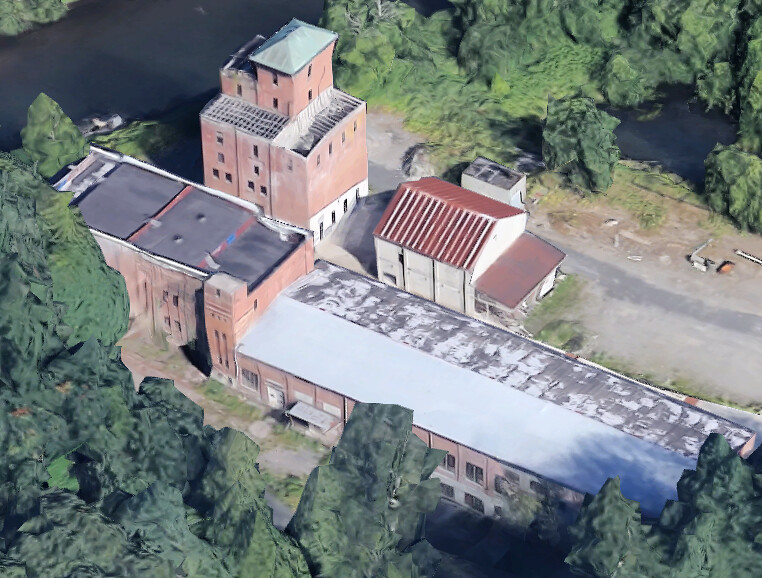
Got to love and hate high resolution images available right at our finger tip these days. It all depends on available source image quality feeding your view and it varies a lot.
Definitely takes quite a bit of bandwidth but neat.
Available resolution is good.
This area is just ok.
| |
That second photo is a trip. You didn't edit it at all? It looks like a painting or like it's been embossed or something. Bizarre!
I wandered till the stars went dim. | |
Ganesha-Google maps -- draw, save and share
http://www.uer.ca/...=1&threadid=119211
I thought this was worth adding. (:
Thanks Ganesha
Let's Go Places |
Add a poll to this thread
This thread is one of your Favourites. Click to make normal.Click to make this thread a Favourite.

| This thread is in a public category, and can't be made private. |
Powered by AvBoard AvBoard version 1.5 alpha
Page Generated In: 140 ms
|
|


