forums
new posts
donate
UER Store
events
location db
db map
search
members
faq
terms of service
privacy policy
register
login


UER Forum > Canada: Other > The students have long gone (Viewed 2886 times)
master private 


Location: Saskatchewan
Gender: Male
Total Likes: 56 likes


 |  | 
The students have long gone
< on 12/21/2014 6:01 AM >
Reply with Quote
Posted on Forum: UER Forum
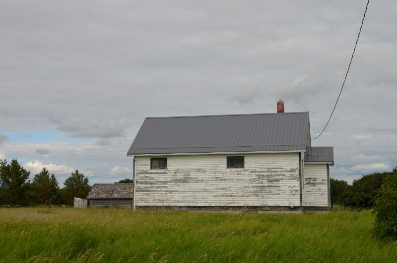
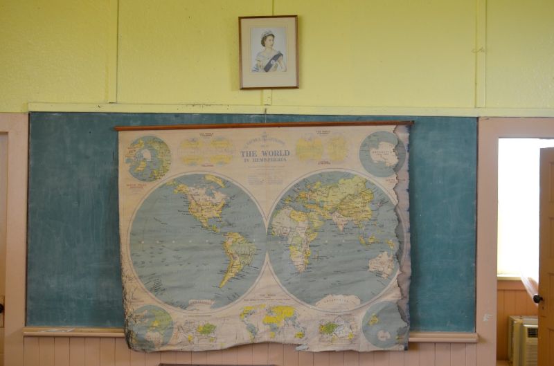
Summer exploring with Sentry finally have time to do some posting . One room school house . map was from the 1930's the world sure has changed. Before the soviet union , before pakistan was a country when empires had colonies .


1.

2.

3.

4.

5.

6.

7.

8.

9.

10.

11.

12.

13.


14.


15.


16.


sentry 


Location: Canada
Gender: Male
Total Likes: 27 likes


 |  |  | 
Re: The students have long gone
< Reply # 1 on 2/14/2015 3:37 AM >
Reply with Quote
Posted on Forum: UER Forum
Yep, that was a neat little spot. So many of them out there...we just have to find them!


"Stone buildings will be among the last to disappear when we're gone. As the fleeting materials of modern construction decompose, the world will retrace our steps back to the Stone Age as it gradually erodes away all memory of us."
SouthPaw 


Location: Allentown/Philadelphia
Gender: Male
Total Likes: 39 likes


 |  | 
Re: The students have long gone
< Reply # 2 on 2/14/2015 7:05 PM >
Reply with Quote
Posted on Forum: UER Forum
I'm surprised by how old the map is. If I had to wager a guess, I'd say it was abandoned after 1952, just because it shows Queen Elizabeth.


tbeckerson 


Gender: Male
Total Likes: 67 likes


 |  | 
Re: The students have long gone
< Reply # 3 on 2/15/2015 4:45 PM >
Reply with Quote
Posted on Forum: UER Forum
Posted by SouthPaw
I'm surprised by how old the map is. If I had to wager a guess, I'd say it was abandoned after 1952, just because it shows Queen Elizabeth.


+1 on the Queen Elizabeth thing. The map itself is much older, I think:

It has Tanganyika territory in Africa, which was created in June 1919, so it can't be any older than that.

It has British Palestine, created in April 1920. but not British Transjordan (April 1921). So it can't be any newer than that.
To maybe narrow it down, Hejaz has it's pre-1916 shape, but wasn't officially recognized in it's new shape until August 1920.

This would mean that the map was the shape of the world between April 1920 - August 1920.
It would be common sense to print a map right before one school year begins, so it would be as accurate as possible for the following year. Allowing for time to print it and ship it, you'd have to print the world as of May-June. Which would be consistent for this map.

However, I'm not a historian, and I've never worked for a map-printing company. I could be totally wrong, and I welcome the input of someone who knows better.


ForgottenRails 


Location: Eastern Ontario
Gender: Male
Total Likes: 68 likes


 |  | 
Re: The students have long gone
< Reply # 4 on 2/15/2015 5:29 PM >
Reply with Quote
Posted on Forum: UER Forum
That's a really cool find, with all the old stuff there.


UER Forum > Canada: Other > The students have long gone (Viewed 2886 times)


Add a poll to this thread


This thread is currently Public. Anyone, including search engines, may see it.


All content and images copyright © 2002-2024 UER.CA and respective creators. Graphical Design by Crossfire.
To contact webmaster, or click to email with problems or other questions about this site: UER CONTACT
View Terms of Service | View Privacy Policy | Server colocation provided by Beanfield
This page was generated for you in 78 milliseconds. Since June 23, 2002, a total of 738549518 pages have been generated.